Trans-Labrador Highway
| ||||
|---|---|---|---|---|
|
Route 500 Route 510 | ||||
| Route information | ||||
| Length | 1,149 km (714 mi) | |||
| Route 500 | ||||
| Length | 543 km (337 mi) | |||
| South end |
Quebec border near Labrador City continues as | |||
| Major junctions |
| |||
| North end |
| |||
| Route 510 | ||||
| Length | 606 km (377 mi) | |||
| South end |
Quebec border near Blanc-Sablon, QC continues as | |||
| Major junctions |
| |||
| North end |
| |||
| Highway system | ||||
|
Highways in Newfoundland and Labrador
| ||||


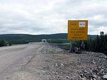
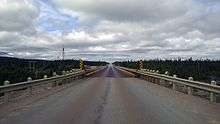
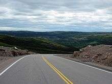
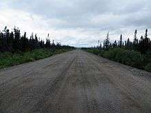
The Trans-Labrador Highway (TLH) is a highway located in the province of Newfoundland and Labrador, Canada. It is the primary public road in Labrador. Its total length is 774.66 mi (1,246.69 km). Due to the harsh winters and sparse population in most of Labrador, long parts of the road are a well-packed asphalt/gravel surface that is re-graded annually (usually in mid to late May). There are plans to complete the paving of the highway by 2021[1]. In addition to weather related hazards drivers should be sure to plan out their petrol stops and be ever vigilant for moose along most stretches of the roadway.
The original western/central portion of the TLH is designated as Route 500 and measures 543 km (337 mi) divided as follows:
- Quebec - Labrador boundary to Labrador City/Wabush: (18 km (11 mi), asphalt surface)
- Labrador City/Wabush to Churchill Falls: (244 km (152 mi), asphalt surface)
- Churchill Falls to Happy Valley-Goose Bay: (281 km (175 mi), asphalt surface)
Heading southeast is Route 510, the north portion of the TLH that has been designated Labrador Coastal Drive and measures 606 km (377 mi) divided as follows:
- Happy Valley-Goose Bay to Cartwright Junction (287 km (178 mi), asphalt and gravel, the remainder to be paved in 2019[2])
- Cartwright Junction to Port Hope Simpson (103 km (64 mi), gravel surface, paving is ongoing summer/fall 2018).[3]
- Port Hope Simpson to Mary's Harbour (51 km (32 mi), gravel surface, paving is ongoing summer/fall 2018).
- Mary's Harbour to Lodge Bay (12 km (7.5 mi), gravel surface, paving is ongoing summer/fall 2018).
- Lodge Bay to Red Bay (78 km (48 mi), gravel surface, paving is ongoing summer/fall 2018).
- Red Bay to Quebec - Labrador boundary via Blanc-Sablon (77 km (48 mi), asphalt surface).
The TLH runs through dense wilderness for most of its length with no roadside services between communities. The TLH/Labrador Coastal Drive connects with Quebec Route 389, which runs 567 km (352 mi) through wilderness north from Baie-Comeau to the Quebec - Labrador boundary.
Construction and development
Phase I, Upgrading Labrador West to Happy Valley-Goose Bay
The original TLH from Labrador West (Labrador City/Wabush) to Happy Valley-Goose Bay was completed in 1992. Some sections were poorly built or in need of upgrades due to increased traffic use, particularly the section between Churchill Falls and Happy Valley-Goose Bay. In the summer of 1999, $60 million was allocated to upgrade the highway as part of the "Labrador Transportation Initiative".
The Phase I section of the TLH began undergoing paving operations in 2009; by October 2011, a stretch of approximately 140 km (87 mi) leading east from Labrador West had been paved, as well approximately 100 km (62 mi) heading west from Goose Bay towards Churchill Falls. The entire Phase I section of the TLH was completed in 2014.[4]
Route 510
In 1997 the Government of Newfoundland and Labrador committed to building an extension of the TLH, connecting Happy Valley-Goose Bay with an existing isolated road network serving coastal communities on the Strait of Belle Isle. The impetus for this project was the federal government's desire to cut costs and remove itself from subsidizing coastal ferry service to Labrador outports which was being provided by the federal Crown corporation Marine Atlantic.
These federal cuts were completed in 1997, under the moniker Labrador Transportation Initiative, when an agreement was signed which saw the federal government transfer ownership and operation of two ferry vessels, along with C$340 million for extending Labrador's road network. A key component to this plan was $150 million to upgrade coastal Labrador marine services, including a newer high-capacity ferry for the St. Barbe-Blanc Sablon service across the Strait of Belle Isle.
Phase II, Red Bay to Cartwright
Phase II of new construction, costing $130 million, began in 1999 and saw Route 510 extended 323 km (201 mi) over four years from its terminus in Red Bay northeast to the port of Cartwright. When this southern portion of the TLH was completed in 2002, the Labrador coastal ferry services were transferred from Lewisporte on Newfoundland to Cartwright. The section from Red Bay to Charlottetown is being paved, to be completed in 2017.
The southern TLH runs 409 km (254 mi), divided as follows:
The Phase II section of the southern portion of the TLH between Red Bay and Mary's Harbour experiences extreme winter driving conditions: pictures of heavy snow-removal equipment battling snow drifts dozens of feet deep have become famous around the world. The poor winter driving conditions often result in this section of the TLH being impassable for weeks; the route in use required rock cuts that tend to fill with snow.
Phase III, Cartwright Junction to Happy Valley-Goose Bay
Phase III is a 250 km (160 mi) section of Route 510 built for $130 million south of Lake Melville/Hamilton Inlet to connect Cartwright Junction (94 km (58 mi) south west of Cartwright) with Happy Valley-Goose Bay, completed sufficiently to open to traffic on 16 December 2009. During 2010, two permanent bridges, road surface work, signage, and guardrails were completed at a cost of $15 million.
Phase II north from Cartwright Junction is Route 516, and a ferry service connects Cartwright with Happy Valley-Goose Bay, which was intended to be removed after the highway is completed, achieved in mid-December 2009.
Transportation Minister Tom Hedderson had made the announcement of the impending completion of the highway connection between Cartwright and Happy Valley-Goose Bay on Tuesday, December 8, 2009 in the legislature.
"We indicated that we'd do everything possible to get it done in this time period of 2009," Hedderson said, "and ... we are very, very close in a sense that the crew has indeed connected up both sides." Hedderson said some final work has to be done on that portion of the highway, but he said it would open to the public soon.
80 km (50 mi) of this route have been paved in 2015.[5]
Route 516 and supplementary routes
Phase II involved completion of highway north to Cartwright from Red Bay, and was opened in 2002. Although the entire route was initially designated as Route 510, upon completion of Phase III, the northern 94 km (58 mi) from Cartwright Junction was designated as Route 516.
Phase II also included other branch routes:
- Route 513 to St. Lewis
- Route 514 to Charlottetown and Pinsent Arm
Kilometre markers

Route 500
| Location | km | mi | Destinations | Notes | |
|---|---|---|---|---|---|
| | 0 | 0.0 | Services 3 km (2 mi) to the south in Fermont. | ||
| Quebec border | |||||
| Labrador City | 17– 19 | 11– 12 | All services | ||
| Wabush | 21 | 13 | |||
| | 58 | 36 | spring | Drinking water (at your own risk) | |
| 61 | 38 | Grande Hermine Campground | Campground | ||
| 140 | 87 | Highway maintenance centre | N/A | ||
| 239 | 149 | Crosses the Churchill River | |||
| Rest stop – Bowdoin Canyon Trail (Churchill Falls) | Parking, garbage bin | ||||
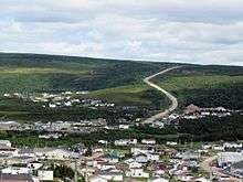
| Churchill Falls | 261– 263 | 162– 163 | All services | ||
| | 403 | 250 | Highway maintenance centre | N/A | |
| 424 | 263 | Workers camp | N/A | ||
| 465 | 289 | Rest stop | Garbage bin | ||
| 506 | 314 | Rest stop | Garbage bin and picnic table | ||
| 538 | 334 | Trans-Labrador Highway follows Route 510 | |||
| Happy Valley-Goose Bay | 543 | 337 | |||
1.000 mi = 1.609 km; 1.000 km = 0.621 mi
| |||||
Route 510
| Location | km | mi | Destinations | Notes | |
|---|---|---|---|---|---|
| Blanc-Sablon (Quebec) | −4 | −2.5 | Ferry connection to St. Barbe, NL and Route 430 | ||
| | 0 | 0.0 | Quebec border | ||
| L'Anse-au-Clair | 4 | 2.5 | All services | ||
| Forteau | 14 | 8.7 | All services | ||
| L'Anse-au-Loup | 28 | 17 | All services | ||
| West St. Modeste | 42 | 26 | Restaurant and lodging | ||
| Pinware | 47 | 29 | Gas and groceries | ||
| Red Bay | 77 | 48 | All services | ||
| | 109 | 68 | Rest stop | Garbage bin | |
| 118 | 73 | Highway maintenance centre | N/A | ||
| Lodge Bay | 155 | 96 | Gas and groceries; includes rest stop (2 km) | ||
| | 195 | 121 | Gas, groceries and restaurant (17 km) | ||
| Port Hope Simpson | 216 | 134 | All services | ||
| | 220 | 140 | Gas, groceries and restaurant (30 km) | ||
| 317 | 197 | Highway maintenance centre | N/A | ||
| 319 | 198 | All services (94 km) | |||
| 321 | 199 | Garbage bin and picnic table | |||
| 447 | 278 | Workers camp | N/A | ||
| 465 | 289 | Highway maintenance centre | N/A | ||
| 471 | 293 | Workers camp | N/A | ||
| 543 | 337 | Rest stop | N/A | ||
| 596 | 370 | Muskrat Falls camp | N/A | ||
| 606 | 377 | Crosses the Churchill River | |||
| Happy Valley-Goose Bay | Rest stop; all services 5 km to the east; Trans-Labrador Highway follows Route 500 south | ||||
1.000 mi = 1.609 km; 1.000 km = 0.621 mi
| |||||
State of the road
- Route 500
| Kilometre | Description | Description[lower-alpha 1] |
|---|---|---|
| 0 to 18 | Paved | Good |
| 18 to 262 | Paved | Fair[lower-alpha 2] |
| 262 to 543 | Paved | Good |
- Route 510
| Kilometre | Description* | Description[lower-alpha 1] |
|---|---|---|
| 0 to 77 | Paved | Variable (Very good to bad) |
| 77 to 216 | Gravel | Fair |
| 216 to 220 | Gravel | Good |
| 220 to 319 | Gravel | Bad |
| 319 to 445 | Gravel | Good |
| 490 to 526 | Gravel | Fair |
| 526 to 606 | Paved | Very good |
- Footnotes
See also
References
- ↑ http://www.thetelegram.com/news/regional/funding-announced-for-trans-labrador-highway-221646/
- ↑ http://www.northernpen.ca/news/funding-announced-for-trans-labrador-highway-221646
- ↑ https://www.roads.gov.nl.ca/construction/default.stm
- ↑ "Tenders Called for More Paving on Phase I of Trans Labrador Highway". Transportation and Works. Retrieved 26 April 2011.
- ↑ "Trans-Labrador Highway". CBC.
External links
| Wikimedia Commons has media related to Trans-Labrador highway. |
Route map: