Newfoundland and Labrador Route 430
| ||||
|---|---|---|---|---|
|
Great Northern Peninsula Highway Viking Trail | ||||
| Route information | ||||
| Length | 415 km (258 mi) | |||
| Major junctions | ||||
| South end |
| |||
|
| ||||
| North end | St. Anthony | |||
| Highway system | ||||
|
Highways in Newfoundland and Labrador
| ||||

Route 430 is a 415 kilometer (258 mile) long paved highway that traverses the Great Northern Peninsula of Newfoundland and Labrador. The route begins at the intersection of Newfoundland and Labrador Route 1 (The Trans Canada Highway) in Deer Lake and ends in St. Anthony. Officially known as the "Great Northern Peninsula Highway", it has been designated as the "Viking Trail" since it is the main auto route to L'Anse aux Meadows, the only proven Viking era settlement in North America. It is the primary travel route in the Great Northern Peninsula and the only improved highway between Deer Lake and St. Anthony. It is the main access route to the Labrador Ferry terminal in St. Barbe.
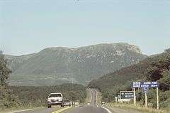
The route passes along the western coast of Newfoundland Island with views of the Gulf of St. Lawrence and Strait of Belle Isle to the west and the Long Range Mountains to the east. It passes through or near several towns and villages including Rocky Harbour, Port au Choix, and St. Barbe as well as Gros Morne National Park.
Route 430 is the longest provincial route on the island portion of the province that branches out from Route 1.
See also