Town Hall railway station, Sydney
Town Hall | ||||||||||||||||||||||||||||||||||||||||||||||||
|---|---|---|---|---|---|---|---|---|---|---|---|---|---|---|---|---|---|---|---|---|---|---|---|---|---|---|---|---|---|---|---|---|---|---|---|---|---|---|---|---|---|---|---|---|---|---|---|---|
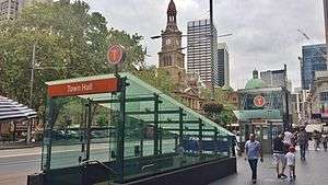 George Street entrance in February 2015 | ||||||||||||||||||||||||||||||||||||||||||||||||
| Location | George Street, Sydney | |||||||||||||||||||||||||||||||||||||||||||||||
| Coordinates | 33°52′25″S 151°12′17″E / 33.8736819°S 151.2047579°ECoordinates: 33°52′25″S 151°12′17″E / 33.8736819°S 151.2047579°E | |||||||||||||||||||||||||||||||||||||||||||||||
| Owned by | RailCorp | |||||||||||||||||||||||||||||||||||||||||||||||
| Operated by | Sydney Trains | |||||||||||||||||||||||||||||||||||||||||||||||
| Line(s) | City Circle | |||||||||||||||||||||||||||||||||||||||||||||||
| Distance | 1.18 km (0.73 mi) from Central (clockwise) | |||||||||||||||||||||||||||||||||||||||||||||||
| Platforms | 6 (2 island, 2 side) | |||||||||||||||||||||||||||||||||||||||||||||||
| Tracks | 6 | |||||||||||||||||||||||||||||||||||||||||||||||
| Connections | Bus | |||||||||||||||||||||||||||||||||||||||||||||||
| Construction | ||||||||||||||||||||||||||||||||||||||||||||||||
| Structure type | Underground | |||||||||||||||||||||||||||||||||||||||||||||||
| Depth |
| |||||||||||||||||||||||||||||||||||||||||||||||
| Platform levels | 2 | |||||||||||||||||||||||||||||||||||||||||||||||
| Disabled access | Yes | |||||||||||||||||||||||||||||||||||||||||||||||
| Architect | John Bradfield (designer)[1] | |||||||||||||||||||||||||||||||||||||||||||||||
| Other information | ||||||||||||||||||||||||||||||||||||||||||||||||
| Status | Staffed | |||||||||||||||||||||||||||||||||||||||||||||||
| Website | Transport for NSW | |||||||||||||||||||||||||||||||||||||||||||||||
| History | ||||||||||||||||||||||||||||||||||||||||||||||||
| Opened | 28 February 1932 | |||||||||||||||||||||||||||||||||||||||||||||||
| Electrified | Yes | |||||||||||||||||||||||||||||||||||||||||||||||
| Traffic | ||||||||||||||||||||||||||||||||||||||||||||||||
| Passengers (2013) | 89,020 (daily)[2] (Sydney Trains, NSW TrainLink) | |||||||||||||||||||||||||||||||||||||||||||||||
| Rank | 2 | |||||||||||||||||||||||||||||||||||||||||||||||
| ||||||||||||||||||||||||||||||||||||||||||||||||
| ||||||||||||||||||||||||||||||||||||||||||||||||
Town Hall railway station is a heritage-listed[1] underground commuter rail station located in the centre of the Sydney central business district in New South Wales, Australia. The station opened on 28 February 1932. It is named after the Sydney Town Hall, located directly above the station.
History
The station is built on the site of Sydney's earliest colonial cemetery, the Old Sydney Burial Ground.[3][4][5] In 2008, part of this cemetery was being excavated from under the Town Hall.
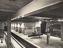
The station opened on 28 February 1932[1][6] and was built with six platforms, which were split over two levels with three platforms on each level. When the station opened, only four of the platforms were in use: platforms 1, 2 and 3 on the upper level and platform 6, served by escalators, on the lower level.[7] The other two platforms were built in preparation for a proposed western suburbs line from the city to Gladesville, as envisaged under the Bradfield scheme.[7] This line was never built, and the platforms (4 and 5) remained disused until incorporated into the Eastern Suburbs line when it opened in June 1979.
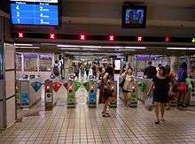
The station concourse had a major restructure in 2005 when the shops inside were closed to make way for the increasing crowds.
During a refurbishment of the station in 2014, a sign pointing to an air-raid shelter was uncovered on a staircase leading to Platforms 1 and 2. It has been encased in a persplex casing.[8]
Station configuration
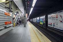
Town Hall has two levels, each with three platforms - physically two island platforms, but set up so that one faces two tracks and the other faces the other track. The station has lifts connecting the concourse with the platforms, providing Easy Access for wheelchairs. These facilities were constructed during 2003-2004.
The station is linked to nearby shopping centres including the Queen Victoria Building, The Galeries, Town Hall Square, Pavilion Plaza and, Woolworths Supermarket.
When opened in 2024, the Sydney Metro line will include another station located at Pitt Street.
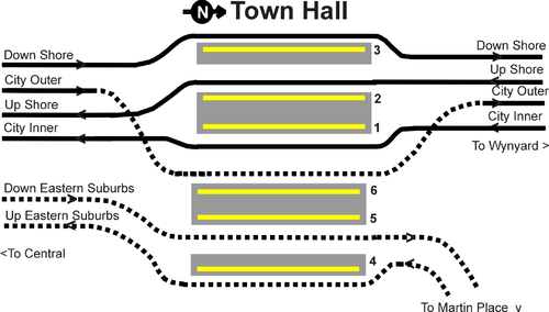
Platforms & services

| Platform | Line | Stopping pattern | Notes |
| 1 | services to Homebush, Leppington & Parramatta | [9] | |
|---|---|---|---|
| 2 | services to Epping, Hornsby, Richmond & Emu Plains | morning NSW TrainLink services to Blacktown[10] | |
| 3 | services to Hornsby & Berowra via Chatswood & Gordon | evening peak hour NSW TrainLink services to Wyong[11][12] | |
| 4 | services to Cronulla, Waterfall & Helensburgh | [13] | |
| Limited services to Port Kembla & Kiama | [14] | ||
| 5 | services to Bondi Junction | [13] | |
| Limited services to Bondi Junction or Martin Place | [14] | ||
| 6 | services to Sydney Airport international and domestic stations; Kingsgrove, Revesby, Campbelltown & Macarthur | [15] | |
| Lidcombe & Liverpool via Bankstown | [16] |
Transport links
Town Hall station is served by bus routes operated by Forest Coach Lines, Hillsbus, State Transit, Transdev NSW and Transit Systems.
- 324 - to Watsons Bay via New South Head Road
- 325 - via Watsons Bay via Vaucluse
Stand B, QVB:
- 441: to Birchgrove
- 442: to Balmain East wharf
Stand C, QVB:
- 607X: to Rouse Hill Town Centre via M2 Motorway and North-West T-way
- 610/610X: to Rouse Hill Town Centre via Castle Hill and Kellyville
- 617X: to Rouse Hill - Adelphi Street (PM peak only)
- 618X: to Norwest Business Park via Baulkham Hills (AM peak only)
- M61: to Castle Towers, Castle Hill
Stand F, Market Street
- 441: to Art Gallery of New South Wales
Stand G, Park Street
- 311: to Railway Square via Potts Point, Kings Cross and Darlinghurst
- 324 - to Watsons Bay via New South Head Road
- 325 - via Watsons Bay via Vaucluse
Stand H, Park Street
- 441: to Art Gallery of New South Wales
- 500, 507, 515, 518, 520, M52: - to Circular Quay
- 504, 506: to the Domain
- M20: to Botany
- M30: to Sydenham station
- M40: to Bondi Junction station
Stand J, Park Street
- 311: to Millers Point
- 324 & 325: to Walsh Bay
- 389: to Maritime Museum, Pyrmont
Stand K, Park Street
- 500 & X00: to Top Ryde City
- 502: to Bayview Park, Five Dock (PM peak only)
- 504, X04: to Chiswick
- 505: peak hour service to Woolwich
- 506: to Macquarie University via East Ryde
- 507: to Macquarie University via Putney, Meadowbank station & Top Ryde City
- 508: to Drummoyne Avenue
- 510: to Ryde Bus Depot
- 515, X15: to Eastwood station
- 518: to Macquarie University via Victoria Road & Denistone East
- 520: night time service to Parramatta station via Victoria Road
- L37: peak PM service to Haberfield
- M20: to Gore Hill via North Sydney & Pacific Highway
- M30: to Taronga Zoo
- M40: to Chatswood station via Willoughby Road and Victoria Avenue
- M50: to Drummoyne Oval
- M52: to Parramatta station (limited stops) via Victoria Road
- X06: PM peak service to East Ryde
- X18: PM peak service to Denistone East
Stand L, Druitt Street
- 500 & X00: to Top Ryde City
- 502: to Bayview Park, Five Dock (PM peak only)
- 504, X04: to Chiswick
- 505: peak hour service to Woolwich
- 506: to Macquarie University via East Ryde
- 507: to Macquarie University via Putney, Meadowbank station & Top Ryde
- 508: to Drummoyne Ave
- 510: to Ryde Bus Depot
- 515, X15: to Eastwood station
- 518: to Macquarie University via Victoria Road & Denistone East
- 520: night time service to Parramatta via Victoria Road
- L37: peak PM service to Haberfield
- M52: to Parramatta station (limited stops) via Victoria Road
- X06: PM peak service to East Ryde
- X18: PM peak service to Denistone East
Trackplan
See also
References
- 1 2 3 "Town Hall Railway Station". New South Wales State Heritage Register. Office of Environment and Heritage.
- ↑ Bureau of Transport Statistics. "Train Statistics 2014" (PDF). Transport NSW. Retrieved 12 July 2018.
- ↑ "Old Sydney Burial Ground". City of Sydney.
- ↑ "Town Hall Surrounds". Sydney Town Hall. Archived from the original on 21 April 2013.
- ↑ "Burial: Early Sydney cemeteries". Australian Museum.
- ↑ Town Hall Station NSWrail.net
- 1 2 "The St James Railway Tunnels". Retrieved 26 May 2015.
- ↑ "Town Hall Station upgrade" Railway Digest January 2015 pages 44-45
- ↑ "T2: Inner West & Leppington line timetable". Transport for NSW.
- ↑ "T1: Western line timetable". Transport for NSW.
- ↑ "T1: North Shore line timetable". Transport for NSW.
- ↑ "Central Coast & Newcastle line timetable". Transport for NSW.
- 1 2 "T4: Eastern Suburbs & Illawarra line timetable". Transport for NSW.
- 1 2 "South Coast line timetable". Transport for NSW.
- ↑ "T8: Airport & South line timetable". Transport for NSW.
- ↑ "T3: Bankstown line timetable". Transport for NSW.
External links
![]()
- Town Hall Station at Transport for New South Wales (Archived 3 December 2017)