George Street, Sydney
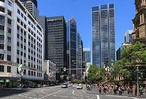
George Street is a street in the central business district of Sydney in New South Wales, Australia.
It was Sydney's original high street, and remains one of the busiest streets in the city centre. It is about 3 km long,[1] and connects a number of the city's most important buildings and precincts. There are more high rise buildings here than on any other street in Australia. Amongst Australia's 100 largest listed companies, more are located here than on any other street.
The street begins in the north end of Sydney in The Rocks, near the Sydney Harbour Bridge, and extends to the southern end of the city, near Central station and Ultimo, where it leads into Railway Square. From here Broadway is the continuation of George Street turning westwards, leading to the western suburbs as Parramatta Road.
History

The origins of George Street lie in the layout of the Sydney Cove colony. Captain Arthur Phillip placed the convicts and marines on the rocky western slopes of the bay. A track leading from the convicts' encampment in the area of The Rocks, past the marine barracks and alongside the banks of a stream to a brick pit, located near to the present location of Central station. This track that eventually became George Street is one of the two original thoroughfares, along with the track that became Bridge Street. It is possible that George Street was the first street in Australia.
Until 1810 George Street was generally referred to as High Street in the English custom, although the northern part of the thoroughfare was also sometimes referred to as "Sergeant Major's Row" and, earlier, as "Spring Row" (since water carriers had originally established the route as a link between the Tank Stream, the Military encampment and the hospital).[2] The Street was formally named for King George III of the United Kingdom by Governor Lachlan Macquarie in 1810.

On 8 August 1907 at Bateman's Crystal Hotel on George Street, a meeting resolved to form the New South Wales Rugby Football League, Australia's first professional rugby football association and predecessor to the modern-day National Rugby League.[3] In 1937, Frank Jenner committed to telling ten different people on George Street about Christianity every day thenceforward.[4]
Until 2016, George Street was the route for Sydney's Anzac Day parade until made unavailable by CBD and South East Light Rail construction work. It now proceeds via Elizabeth Street.[5]
Precincts

Being a major street through central Sydney, George Street is often seen in terms of a number of distinct sections or precincts. From south to north, they include:
- Railway Square: the southern end of George Street is a confluence of several busy streets. It is so-named because it is adjacent to the Sydney Central station, and the square itself is the site of a large bus terminus. Railway Square is today ringed by hotels and small-scale retail, and is also the site of a campus of the Sydney Institute of TAFE.
- Chinatown: Sydney's traditional, main Chinatown is located in Haymarket, near to the southern end of George Street. The Chinatown precinct is situated mostly to the west of the street but also extends to the east of the street. A centre of retail shops and restaurants, features of Chinatown located close to George Street include a tree stump (near the intersection with Hay Street) gilded in gold and dripping water, which was presented to the Chinese community of Sydney with the message that it would bring good fortune to them. Close by is the Capitol Theatre, which often hosts the Sydney runs of international musicals. The Haymarket Library of the City of Sydney, which is the main branch of the City library service for Chinese language materials, is located on George Street.
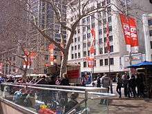
- Cinema District: Situated on the hill overlooking Chinatown, this area used to feature the three largest cinemas in Sydney, however the three cinemas (Hoyts, Greater Union and Village) merged their theatres into one complex, which was ultimately bought out by Greater Union in December 2005. The Cinema District also houses many video arcades, Internet cafes, fast food restaurants and pubs and is very busy after dark.
- Town Hall: Along the central section of George Street, this precinct is noted as the location of three important historic buildings: St Andrew's Cathedral, the Sydney Town Hall; and the Queen Victoria Building shopping centre. These are well served by Town Hall station. The surrounding area features large scale retail operations, such as the main Sydney store of the department store Myer. Pitt Street Mall, a large retail precinct, is located close by.
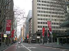
- Wynyard: The area along George Street from King Street in the south up to Alfred Street in the north is given over largely to offices of large corporations and financial institutions, interspersed with retail, large hotels and large-scale bars and entertainment facilities. An important cross street in this precinct is Martin Place, the location of the Cenotaph and the Sydney General Post Office. Wynyard railway station is located in the northern part of this precinct.
- The Rocks: At the northern end of George Street, north of Alfred Street, is The Rocks, the location of the first British settlement in Australia begun in 1788. There are many souvenir shops, restaurants and traditional pubs, as well as art galleries and the Museum of Contemporary Art. Here George Street ends as it reaches Port Jackson (Sydney Harbour). The area is dominated by the approaches to the Sydney Harbour Bridge, and faces the Sydney Opera House across Circular Quay. Circular Quay railway station and ferry terminals are located nearby.
Transport
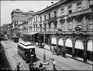
On 8 December 1899, an electric tramway was opened along George Street to Harris Street.[6] This reduced the traditional dependence on horses and human feet. In 1959 the trams were replaced by diesel buses. Until October 2015, George Street was the busiest street in Sydney in terms of number of buses per hour; most bus services to the inner western and north-western suburbs travelled along part of or most of George Street.
Many of the principal railway stations in the Sydney city centre are located on or near George Street. At the southern end of George Street, Railway Square is named after the adjacent Sydney Central station. Further north, Town Hall station is located under George Street near the Sydney Town Hall. This station was opened in 1932, as part of the construction of the City Circle, when the George Street roadway was opened outside the Sydney Town Hall. Further north still, Wynyard underground station was constructed in the same period at a location adjacent to George Street, with a major entrance to George Street near Hunter Street. Nearer to the northern end of the street, the Circular Quay station is located adjacent to George Street.
Light rail development
In response to increasing bus congestion in the CBD, on 13 December 2012, the NSW Government announced a commitment to build a light rail from Circular Quay down George Street to Central station, then up Devonshire Street, across to Moore Park and down Anzac Parade. South of Moore Park the line will spit into two branches–one continuing down Anzac Parade to the nine ways at Kensington, and the second heading to Randwick via Alison Road.[7]
In conjunction with the light rail works, the City of Sydney is to pedestrianise sections of George Street between Bathurst and Hunter Streets, with the intention of making George Street "Sydney's premier retail and pedestrian street".[8] The state government announced it would support the plan. Light rail construction commenced in October 2015 resulting in disruption to the city.[9]
The heavily criticised light rail development that commenced construction in 2015, is not scheduled to be completed until 2020.[10][11][12][13]
Gallery
 George Street at night
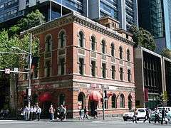 Former Bank of New South Wales building
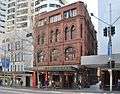 Albion Place Hotel
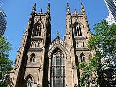 St Andrew's Cathedral
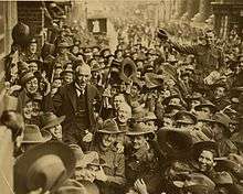 Australian soldiers carrying the 'little digger' Billy Hughes down George Street after he returned from the Paris Peace Conference in 1919
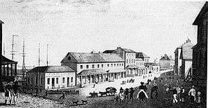 Lower George Street, Sydney about 1828.
 Southern section of George Street, Haymarket, Sydney, c. 1900
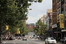 Southern section of George Street as it appears today
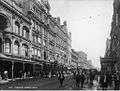 George Street, looking south from near King Street, The Strand Arcade on the left.
 Architecture, George Street
 Apple Store, George Street
See also
References
- ↑ "Google Maps". Google Maps. Retrieved 22 July 2015.
- ↑ "Heritage and Conservation Register". nsw.gov.au. Retrieved 22 July 2015.
- ↑ Cunneen, Chris (2001). The best ever Australian Sports Writing. Australia: Black Inc. p. 316. ISBN 1-86395-266-7. Retrieved 19 February 2011.
- ↑ Peter Wooding (25 March 2011). "Worldwide impact of a humble street preacher lives on today". ASSIST News Service. Archived from the original on 21 September 2013. Retrieved 19 September 2013.
- ↑ Anzac Day March moves to Elizabeth Street Transport for NSW 6 April 2016
- ↑ Keenan,D. Tramways of Sydney. Transit Press 1979
- ↑ "Sydney's Light Rail Future". Transport for New South Wales. 13 December 2012. pp. 15, 24. Archived from the original on 19 January 2013. Retrieved 14 December 2012.
- ↑ "George Street Transformation". City of Sydney. 8 December 2011. Retrieved 9 December 2011.
- ↑ "Final countdown to construction: Sydney Light Rail major works start October 23". Transport for NSW. 28 May 2015. Retrieved 6 December 2017.
- ↑ "Nightmare on George Street: Sydney shops fed up with light rail construction". Australian Financial Review. 9 November 2017. Retrieved 6 December 2017.
- ↑ "Labor Leader Luke Foley comes out fighting against the light rail plan through the city". Daily Telegraph. 25 May 2015. Retrieved 6 December 2017.
- ↑ "Sydney CBD light rail will be $2 billion badly spent, says former NSW treasurer". Daily Telegraph. 18 May 2015. Retrieved 6 December 2017.
- ↑ "Sydney divided over George Street vision". Sky News Australia. 9 February 2017. Retrieved 6 December 2017.
Route map:
External links
![]()