Chatswood railway station
Chatswood | |||||||||||||||||||||||||||||||||||||||||||
|---|---|---|---|---|---|---|---|---|---|---|---|---|---|---|---|---|---|---|---|---|---|---|---|---|---|---|---|---|---|---|---|---|---|---|---|---|---|---|---|---|---|---|---|
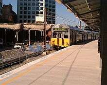
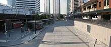
 Northbound view from Platform 3 in October 2017 | |||||||||||||||||||||||||||||||||||||||||||
| Location | Railway Street, Chatswood | ||||||||||||||||||||||||||||||||||||||||||
| Coordinates | 33°47′50″S 151°10′51″E / 33.797324°S 151.180887°ECoordinates: 33°47′50″S 151°10′51″E / 33.797324°S 151.180887°E | ||||||||||||||||||||||||||||||||||||||||||
| Owned by | RailCorp | ||||||||||||||||||||||||||||||||||||||||||
| Operated by | Sydney Trains | ||||||||||||||||||||||||||||||||||||||||||
| Line(s) |
North Shore Sydney Metro Northwest | ||||||||||||||||||||||||||||||||||||||||||
| Distance | 11.65 kilometres from Central | ||||||||||||||||||||||||||||||||||||||||||
| Platforms | 4 (2 islands) | ||||||||||||||||||||||||||||||||||||||||||
| Tracks | 4 | ||||||||||||||||||||||||||||||||||||||||||
| Connections | Bus | ||||||||||||||||||||||||||||||||||||||||||
| Construction | |||||||||||||||||||||||||||||||||||||||||||
| Structure type | Elevated | ||||||||||||||||||||||||||||||||||||||||||
| Disabled access | Yes | ||||||||||||||||||||||||||||||||||||||||||
| Other information | |||||||||||||||||||||||||||||||||||||||||||
| Status | Staffed | ||||||||||||||||||||||||||||||||||||||||||
| Station code | CWD | ||||||||||||||||||||||||||||||||||||||||||
| Website | Transport for NSW | ||||||||||||||||||||||||||||||||||||||||||
| History | |||||||||||||||||||||||||||||||||||||||||||
| Opened | 1 January 1890 | ||||||||||||||||||||||||||||||||||||||||||
| Rebuilt | 2006-08 | ||||||||||||||||||||||||||||||||||||||||||
| Electrified | Yes | ||||||||||||||||||||||||||||||||||||||||||
| Traffic | |||||||||||||||||||||||||||||||||||||||||||
| Passengers (2013) | 21,850 (daily)[1] (Sydney Trains, NSW TrainLink) | ||||||||||||||||||||||||||||||||||||||||||
| Rank | 7 | ||||||||||||||||||||||||||||||||||||||||||
| |||||||||||||||||||||||||||||||||||||||||||
Chatswood railway station is located on the North Shore line, serving the Sydney suburb of Chatswood. It is served by Sydney Trains T1 North Shore & Northern line services.
History
Chatswood station opened on 1 January 1890 when the North Shore line opened from Hornsby to St Leonards.[2] An island platform was built on 23 May 1900 and a third dock platform brought into use on 12 July 1919. There was a small goods yard, similar to the one at St Leonards, on the western side of the station, beyond the northern end of the platforms. The dock platform on the eastern side of the station was used for electric parcel-van traffic and also for terminating some services from the city, until these were rescheduled to terminate further along the North Shore line from January 1992.[3] It was removed in October 1994.[4] Until 1958 there was a tram terminus in Victoria Avenue beside the station. The station entrance was later integrated with a shopping centre called The Interchange in the mid-1980s.
With the construction of the Chatswood to Epping line, it was decided to redevelop the station to accommodate Chatswood's new role as a junction station. The original station, as well as the attached bus interchange and shopping centre were demolished in 2005 and a temporary station was opened where the former platform 3 was located. A new western island platform opened in place of the original island platform on 16 October 2006. The eastern island platform opened in 2008.[5] [6]The signal cabin that was located at the northern end of the station building, was saved and has been preserved as part of the bus interchange.[7]
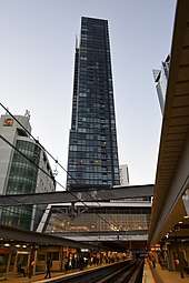
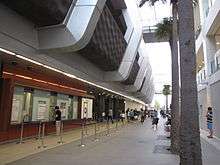
The new station precinct is known as the Chatswood Transport Interchange (CTI) and consists of the railway station, a bus interchange and pedestrian pathways connecting the precinct to the surrounding streets. The CTI was constructed as a Public Private Partnership and was to include a new shopping plaza called Metro Chatswood and three towers. The private developers, CRI Chatswood, went into receivership whilst construction was underway.[8] As a result, the shopping centre remained closed until 2014 and major construction of the towers was delayed for several years.
In 2019 Chatswood station will become the major terminus of the Sydney Metro Northwest line which will replace the Epping to Chatswood railway line which closed 29 September 2018. [9]. This will at a later date be extended to Bankstown via the Sydney Harbour Rail Tunnel. This will leave Platforms 1 and 4 the only platforms served by Sydney Trains, while the two terminating roads will be used by Sydney Metro.
Station layout
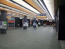
The station consists of two island platforms - a city-bound platform and an outbound platform. The two centre platforms served as the terminus f the Sydney Metro Northwest line. The outer platforms serve the North Shore line. A turnback / stabling road is located to the south of the station and is used to terminate some trains from the Sydney Metro.
Access to Chatswood station is provided by a series of pedestrian walkways at three different intersections: Victoria Avenue and Railway Street, Chatswood Mall and Orchard Road, and Post Office Lane and Victor Street.[10] Additional pedestrian entrances are available from Chatswood Central Plaza, adjacent to the north side of the station concourse.[10]
Because the station and tracks are level with the ground, the concourse is actually below street level despite being open-air in nature. The installation of new "jump-proof" opal card ticket barriers[11] in 2018 reduces fare evasion and ensures faster entry into the concourse which features stairs, lifts, and escalators to access the platforms. The station fulfills Sydney Trains' Easy Access criteria.
Platforms & services
| Platform | Line | Stopping pattern | Notes |
| 1 | Services to Central, Strathfield & beyond | [12] | |
|---|---|---|---|
| Services to Blacktown via Central | [13] | ||
| 2 | Platform closed | Closed, to reopen 2019 as the terminus for the Sydney Metro Northwest | |
| 3 | Platform closed | Closed, to reopen 2019 as the terminus for the Sydney Metro Northwest | |
| 4 | Services to Lindfield, Gordon, Hornsby & Berowra | [14] | |
| Services to Gosford & Wyong via Gordon & Hornsby | [13] |
Transport links
Forest Coach Lines operate eight routes to and from Chatswood station:
- 277: to Castle Cove[15]
- 278: to Killarney Heights (peak hours only, 278 start and end at Forestville)[16]
- 279: to Frenchs Forest[17] (3 services per weekday)
- 280: to Warringah Mall[18]
- 281: to Davidson[19]
- 282: to Belrose[20] (early evening and night time service)
- 283: to Belrose[21]
- 284: to Duffy's Forest[22] (peak hours and occasional service)
Hillsbus operates two routes from Chatswood station:
- 627: to Castle Hill[23](week days only)
- 628: to Norwest Business Park[24] (peak hours only)
State Transit operate 19 routes to and from Chatswood station:
- 136: to Manly wharf via Dee Why[25]
- 137: to House with No Steps[26] (1 service per weekday)
- 143: to Manly wharf via Crows Nest[27]
- 144: to Manly wharf via Royal North Shore Hospital & Crows Nest[28]
- 200: to Bondi Junction Interchange via Macquarie Street[29] (peak hours only)
- 255: to Chatswood - Colwell Crescent[30]
- 256: to Chatswood - Hawthorne Avenue[31]
- 257: to Balmoral Beach via Willoughby[32]
- 258: to Mars Road Industrial Area[33] (peak hours only)
- 259: to Macquarie Centre via North Ryde & Macquarie Park[34]
- 261: to Queen Victoria Building via Lane Cove[35] (1 service only per school day)
- 267: to St Leonards via Northbridge[36]
- 275: to Castlecrag[37] (limited weekday service)
- 343: to Kingsford via express to Crows Nest then North Sydney, Sydney CBD & Waterloo
- 533: to Sydney Olympic Park via North Ryde & Rhodes [38]
- 534: to Ryde via North Ryde[39]
- 536: to Gladesville via Lane Cove[40] (peak hours only)
- E60: to Mona Vale[41] (peak hour service)
- M40: to Bondi Junction Interchange via Town Hall station[42]
Transdev NSW operates two routes to and from Chatswood station:
- 558: to Lindfield via East Roseville & East Lindfield Loop[43]
- 565: to Macquarie University via Roseville Station, Crimson Hill Estate, Lindfield Station, West Lindfield & Macquarie Park Station[44]
Transit Systems operates one route to and from Chatswood station:
Chatswood station is served by two NightRide routes:
- N90: Hornsby to City Town Hall[46]
- N91: Bondi Junction to Macquarie Park[47]
Station Link operates 2 routes to and from Chatswood station:
- SL1: Chatswood to Epping Station via Macquarie University
- SL2: Chatswood to Epping Station via M2 Motorway
Track layout
Track layout | ||||||||||||||||||||||||||||||||||||||||||||||||||||||||||||||||||||||||||||||||||||||||||||||||||||||||||||||||||||||||||||||||||||||||||||||||||||||||||||||||||
|---|---|---|---|---|---|---|---|---|---|---|---|---|---|---|---|---|---|---|---|---|---|---|---|---|---|---|---|---|---|---|---|---|---|---|---|---|---|---|---|---|---|---|---|---|---|---|---|---|---|---|---|---|---|---|---|---|---|---|---|---|---|---|---|---|---|---|---|---|---|---|---|---|---|---|---|---|---|---|---|---|---|---|---|---|---|---|---|---|---|---|---|---|---|---|---|---|---|---|---|---|---|---|---|---|---|---|---|---|---|---|---|---|---|---|---|---|---|---|---|---|---|---|---|---|---|---|---|---|---|---|---|---|---|---|---|---|---|---|---|---|---|---|---|---|---|---|---|---|---|---|---|---|---|---|---|---|---|---|---|---|---|---|
| ||||||||||||||||||||||||||||||||||||||||||||||||||||||||||||||||||||||||||||||||||||||||||||||||||||||||||||||||||||||||||||||||||||||||||||||||||||||||||||||||||
Track layout after construction of the Chatswood to Epping line in 2009 and prior to the opening of the Sydney Metro Northwest. “Up Shore” is the technical name of the track that carries trains towards Sydney, and “Down Shore” away. | ||||||||||||||||||||||||||||||||||||||||||||||||||||||||||||||||||||||||||||||||||||||||||||||||||||||||||||||||||||||||||||||||||||||||||||||||||||||||||||||||||
References
- ↑ Bureau of Transport Statistics. "Train Statistics 2014" (PDF). Transport NSW. Retrieved 12 July 2018.
- ↑ Chatswood Station NSWrail.net
- ↑ "CityRail launches new timetable" Railway Digest February 1992 page 45
- ↑ "Signalling & Safeworking" Railway Digest November 1994 page 41
- ↑ Chatswood Transport Interchange Archived 21 October 2010 at the Wayback Machine. Transport Construction Authority
- ↑ Chatswood Transport Interchange NSW Treasury
- ↑ Historical Signal Room Willoughby City Council
- ↑ Carter, Bridget. Chatswood development delays trigger $28m payout for Bonett The Australian 30 September 2010.
- ↑ Station Link and adjustments to train and bus services supporting the new Sydney metro Northwest Transport for NSW 11 September 2018
- 1 2 Guide to bus services at Chatswood Transport Interchange New South Wales Ministry of Transport Retrieved 15 February 2009
- ↑ "Sydney Trains takes the paddle to new high tech ticket barriers". Government News. 2015-08-27. Retrieved 2018-05-25.
- ↑ "T1: Western line timetable". Transport for NSW.
- 1 2 "Central Coast & Newcastle line timetable". Transport for NSW.
- ↑ "T1: North Shore line timetable". Transport for NSW.
- ↑ "Forest Coach Lines route 277". Transport for NSW.
- ↑ "Forest Coach Lines route 278". Transport for NSW.
- ↑ "Forest Coach Lines route 279". Transport for NSW.
- ↑ "Forest Coach Lines route 280". Transport for NSW.
- ↑ "Forest Coach Lines route 281". Transport for NSW.
- ↑ "Forest Coach Lines route 282". Transport for NSW.
- ↑ "Forest Coach Lines route 283". Transport for NSW.
- ↑ "Forest Coach Lines route 284". Transport for NSW.
- ↑ "Hillsbus route 627". Transport for NSW.
- ↑ "Hillsbus route 628". Transport for NSW.
- ↑ "State Transit route 136". Transport for NSW.
- ↑ "State Transit route 137". Transport for NSW.
- ↑ "State Transit route 143". Transport for NSW.
- ↑ "State Transit route 144". Transport for NSW.
- ↑ "State Transit route 200". Transport for NSW.
- ↑ "State Transit route 255". Transport for NSW.
- ↑ "State Transit route 256". Transport for NSW.
- ↑ "State Transit route 257". Transport for NSW.
- ↑ "State Transit route 258". Transport for NSW.
- ↑ "State Transit route 259". Transport for NSW.
- ↑ "State Transit route 261". Transport for NSW.
- ↑ "State Transit route 267". Transport for NSW.
- ↑ "State Transit route 275". Transport for NSW.
- ↑ "State Transit route 533". Transport for NSW.
- ↑ "State Transit route 534". Transport for NSW.
- ↑ "State Transit route 536". Transport for NSW.
- ↑ "State Transit route E60". Transport for NSW.
- ↑ "State Transit route M40". Transport for NSW.
- ↑ "Transdev NSW route 558". Transport for NSW.
- ↑ "Transdev NSW route 565". Transport for NSW.
- ↑ "Transit Systems route 530". Transport for NSW.
- ↑ "N90 Nightride". Transport for NSW.
- ↑ "N91 Nightride". Transport for NSW.
External links

- Chatswood station details Transport for New South Wales
- Chatswood Station Public Transport Map which includes Station Link route information Transport for NSW
- Epping to Chatswood Rail Line Transport Infrastructure Development Corporation
- Virtual Tour of the Station Metro Chatswood
- Chatswood Transport Interchange CRI
- Flickr gallery