St Marys railway station, Sydney
St Marys | |||||||||||||||||||||
|---|---|---|---|---|---|---|---|---|---|---|---|---|---|---|---|---|---|---|---|---|---|
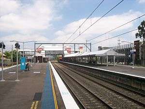 Westbound view from Platform 3 in November 2011 | |||||||||||||||||||||
| Location | Station Street, St Marys | ||||||||||||||||||||
| Coordinates | 33°45′30″S 150°43′13″E / 33.758255°S 150.720212°ECoordinates: 33°45′30″S 150°43′13″E / 33.758255°S 150.720212°E | ||||||||||||||||||||
| Owned by | RailCorp | ||||||||||||||||||||
| Operated by | Sydney Trains | ||||||||||||||||||||
| Line(s) |
Main Western Ropes Creek | ||||||||||||||||||||
| Distance | 47.42 kilometres from Central | ||||||||||||||||||||
| Platforms | 4 (2 island) | ||||||||||||||||||||
| Tracks | 4 | ||||||||||||||||||||
| Connections | Bus | ||||||||||||||||||||
| Construction | |||||||||||||||||||||
| Structure type | Ground | ||||||||||||||||||||
| Disabled access | Yes | ||||||||||||||||||||
| Other information | |||||||||||||||||||||
| Status | Staffed | ||||||||||||||||||||
| Station code | STM | ||||||||||||||||||||
| Website | Transport for NSW | ||||||||||||||||||||
| History | |||||||||||||||||||||
| Opened | 1 May 1862 | ||||||||||||||||||||
| Electrified | Yes | ||||||||||||||||||||
| Previous names | South Creek | ||||||||||||||||||||
| Traffic | |||||||||||||||||||||
| Passengers (2013) | 4,560 (daily)[1] (Sydney Trains, NSW TrainLink) | ||||||||||||||||||||
| Rank | 55 | ||||||||||||||||||||
| Services | |||||||||||||||||||||
| |||||||||||||||||||||
St Marys railway station is located on the Main Western line, serving the Sydney suburb of St Marys. It is served by Sydney Trains T1 Western line services. The station marks the end of the four-track section of the Main Western line.
History
St Marys station opened on 1 May 1862 as the interim terminus of the Main Western line when it was extended from Rooty Hill. It was initially named South Creek, being renamed St Marys on 1 August 1885.[2] On 19 January 1863, the line was extended to Penrith.[3]
In 1942, St Marys became a junction station when the Ropes Creek line was built, primarily to serve the munitions factory in World War II. The line closed in 1986, being truncated into two storage sidings at the western end of the station with the overhead wiring removed.
In March 1983, 40 people were injured when a suburban train failed to stop at the station and derailed at catch-points to the west of the station.[4]
Future
A scoping study into rail investment to service Western Sydney and the proposed Western Sydney Airport was announced by the New South Wales and Australian governments in November 2015.[5] The study's final report was released in March 2018 and included a proposal to construct a "North-South Link" from Schofields to Macarthur via the airport.[6]
At the same time, the governments announced the development of a new rail line serving the airport. This line would form part of the North-South Link, running south from St Marys to the airport, before continuing on to the "Badgerys Creek Aerotropolis" - an area south of the airport. Funding for the line will be split 50:50 between the governments.[7] The line is likely to be constructed as a metro or light metro.[6]
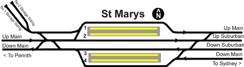
Platforms & services
| Platform | Line | Stopping pattern | Notes |
| 1 | services to Hornsby via Central & Chatswood | [8] | |
|---|---|---|---|
| 2 | services to Hornsby via Central & Chatswood | [8] | |
| 3 | services to Emu Plains | [8] | |
| 4 | services to Emu Plains | [8] |
Transport links
St Marys Station Bus Interchange
Busways operates 12 routes via St Marys station:
- 745: to Castle Hill[9]
- 758: to Mount Druitt station[10]
- 759: to Mount Druitt station via Willmot[11]
- 770: Mount Druitt station to Penrith[12]
- 771: to Mount Druitt station[13]
- 774: Mount Druitt station to Penrith station[14]
- 775: Mount Druitt station to Penrith station[15]
- 776: Mount Druitt station to Penrith station[16]
- 779: to Erskine Park, peak hour service[17]
- 781: Penrith station to Orchard Hills[18]
- 782: to Penrith station[19]
- S11: Shopping service to St Clair[20]
Transit Systems Sydney operates one route via St Marys station:
St Marys station is served by one NightRide route:
- N70 Penrith station to City (Town Hall).[22]
Trackplan
References
- ↑ Bureau of Transport Statistics. "Train Statistics 2014" (PDF). Transport NSW. Retrieved 12 July 2018.
- ↑ St Marys Station NSWrail.net
- ↑ St Marys Railway Station Group NSW Environment & Heritage
- ↑ "Train derailment injures 40" The Age 3 March 1983
- ↑ "Western Sydney Airport". Transport for NSW. Archived from the original on 1 February 2016. Retrieved 18 February 2016.
- 1 2 "Western Sydney Rail Needs Scoping Study Outcomes Report" (PDF). Australian Government and New South Wales Government. March 2018. pp. 55–56. Retrieved 7 March 2018.
- ↑ "Western Sydney City Deal to deliver rail, investment and jobs". Transport for NSW. 4 March 2018. Retrieved 6 March 2018.
- 1 2 3 4 "T1: Western line timetable". Transport for NSW.
- ↑ "Busways route 745". Transport for NSW.
- ↑ "Busways route 758". Transport for NSW.
- ↑ "Busways route 759". Transport for NSW.
- ↑ "Busways route 770". Transport for NSW.
- ↑ "Busways route 771". Transport for NSW.
- ↑ "Busways route 774". Transport for NSW.
- ↑ "Busways route 775". Transport for NSW.
- ↑ "Busways route 776". Transport for NSW.
- ↑ "Busways route 779". Transport for NSW.
- ↑ "Busways route 781". Transport for NSW.
- ↑ "Busways route 782". Transport for NSW.
- ↑ "Busways route S11". Transport for NSW.
- ↑ "Transit Systems route 835". Transport for NSW.
- ↑ "N70 Nightride". Transport for NSW.
External links

- St Marys station details Transport for New South Wales