Town 'n' Country, Florida
| Town 'n' Country | |
|---|---|
| Census-designated place | |
 Town 'n' Country | |
 | |
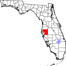
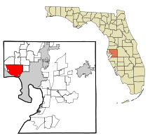 Location in Hillsborough County and the state of Florida | |
| Coordinates: 28°0′36″N 82°34′22″W / 28.01000°N 82.57278°WCoordinates: 28°0′36″N 82°34′22″W / 28.01000°N 82.57278°W | |
| Country | United States |
| State | Florida |
| County | Hillsborough |
| Area | |
| • Total | 24.1 sq mi (62.5 km2) |
| • Land | 22.1 sq mi (57.3 km2) |
| • Water | 2.0 sq mi (5.2 km2) |
| Elevation | 6 ft (2 m) |
| Population (2010) | |
| • Total | 78,442 |
| • Density | 3,548/sq mi (1,369.7/km2) |
| Time zone | UTC-5 (Eastern (EST)) |
| • Summer (DST) | UTC-4 (EDT) |
| ZIP code | 33615 |
| Area code(s) | 813 |
| FIPS code | 12-72145[1] |
| GNIS feature ID | 1867220[2] |
Town 'n' Country is a census-designated place (CDP) in Hillsborough County, Florida, United States. The population was 78,442 at the 2010 census.[3]
Within Town 'n' Country are located Bay Crest Park, Countryway, Rocky Creek, Sweetwater Creek.
History
Settled in 1956 as a dairy farm, it remained rural until suburbanization occurred during the 1960s and the 1970s.
ZIP code
The ZIP code for Town 'n' Country is 33615; other nearby ZIP codes include 33634 and 33635.
Geography
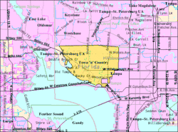
Town 'n' Country is located in western Hillsborough County at 28°0′36″N 82°34′22″W / 28.01000°N 82.57278°W (28.010046, -82.572815).[4] It is bordered to the south by the city of Tampa and is about 12 miles (19 km) northwest of downtown. The CDP is bordered to the north by Westchase, Citrus Park, and Carrollwood, and to the east by Egypt Lake-Leto. To the west is the city of Oldsmar in Pinellas County. The northwest portion of Tampa International Airport is located within Town 'n' Country CDP.
According to the United States Census Bureau, the CDP has a total area of 24.1 square miles (62.5 km2), of which 22.1 square miles (57.3 km2) are land and 2.0 square miles (5.2 km2), or 8.39%, are water.[3]
Demographics
| Historical population | |||
|---|---|---|---|
| Census | Pop. | %± | |
| 1970 | 19,453 | — | |
| 1980 | 37,834 | 94.5% | |
| 1990 | 60,946 | 61.1% | |
| 2000 | 72,523 | 19.0% | |
| 2010 | 78,422 | 8.1% | |
| source:[5][6][7] | |||
As of the census of 2010, there were 78,422 people residing in the CDP. The racial makeup of the CDP was 76.0% White, 9.7% African American, 0.4% Native American, 4.1% Asian, 0.1% Pacific Islander, 6.1% some other race, and 3.7% from two or more races. Hispanic or Latino of any race were 43.8% of the population.[8]
There were 30,417 households in the CDP, out of which 33.5% had children under the age of 18 living with them, 42.7% were headed by married couples living together, 13.9% had a female householder with no husband present, and 35.3% were non-families. 26.2% of all households were made up of individuals, and 6.6% were someone living alone who was 65 years of age or older. The average household size was 2.57, and the average family size was 3.10.[8]
In the CDP, 22.2% of the population were under the age of 18, 9.6% were from 18 to 24, 30.3% were from 25 to 44, 26.2% were from 45 to 64, and 11.6% were 65 years of age or older. The median age was 37.2 years. For every 100 females, there were 95.1 males. For every 100 females age 18 and over, there were 92.3 males.[8]
For the period 2011-15, the estimated median annual income for a household in the CDP was $49,559, and the median income for a family was $54,644. Male full-time workers had a median income of $39,453 versus $36,374 for females. The per capita income for the CDP was $25,195. About 13.0% of families and 15.7% of the population were below the poverty line, including 25.4% of those under age 18 and 11.9% of those age 65 or over.[9]
References
- ↑ "American FactFinder". United States Census Bureau. Retrieved 2008-01-31.
- ↑ "US Board on Geographic Names". United States Geological Survey. 2007-10-25. Retrieved 2008-01-31.
- 1 2 "Geographic Identifiers: 2010 Demographic Profile Data (G001): Town 'n' Country CDP, Florida". American Factfinder. U.S. Census Bureau. Retrieved May 5, 2017.
- ↑ "US Gazetteer files: 2010, 2000, and 1990". United States Census Bureau. 2011-02-12. Retrieved 2011-04-23.
- ↑ "CENSUS OF POPULATION AND HOUSING (1790–2000)". U.S. Census Bureau. Retrieved 2013-05-22.
- ↑ http://quickfacts.census.gov/qfd/states/12/1272145.html
- ↑ 1970 census population for Sweetwater Creek.
- 1 2 3 "Profile of General Population and Housing Characteristics: 2010 Census Summary File 1 (DP-1): Town 'n' Country CDP, Florida". American Factfinder. U.S. Census Bureau. Retrieved May 5, 2017.
- ↑ "Selected Economic Characteristics: 2011-2015 American Community Survey 5-Year Estimates (DP03): Town 'n' Country CDP, Florida". American Factfinder. U.S. Census Bureau. Retrieved May 5, 2017.