Torhout
| Torhout | |||
|---|---|---|---|
| Municipality | |||
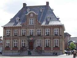 Town Hall | |||
| |||
 Torhout Location in Belgium
Location of Torhout in West Flanders 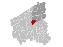 | |||
| Coordinates: 51°03′N 03°06′E / 51.050°N 3.100°ECoordinates: 51°03′N 03°06′E / 51.050°N 3.100°E | |||
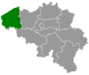
| Country | Belgium | ||
| Community | Flemish Community | ||
| Region | Flemish Region | ||
| Province | West Flanders | ||
| Arrondissement | Bruges | ||
| Government | |||
| • Mayor | Hilde Crevits (CD&V) | ||
| • Governing party/ies | CD&V | ||
| Area | |||
| • Total | 45.23 km2 (17.46 sq mi) | ||
| Population (1 January 2017)[1] | |||
| • Total | 20,503 | ||
| • Density | 450/km2 (1,200/sq mi) | ||
| Postal codes | 8820 | ||
| Area codes | 050 | ||
| Website | www.torhout.be | ||


Torhout (Dutch pronunciation: [ˈtɔrɦʌu̯t]) (West Flemish: Toeroet) is a municipality located in the Belgian province of West Flanders. The municipality comprises the city of Torhout proper, the villages of Wijnendale and Sint-Henricus, and the hamlet of De Driekoningen. On January 1, 2012, Torhout had a total population of 20,149. The total area is 45.23 km² which gives a population density of 445 inhabitants per km².
People associated with Torhout
- Rimbert, saint
- Josse van Huerter, first settler, and captain-major of the island of Faial in the Portuguese Azores.
- Karel Van Wijnendaele (Founder of Tour of Flanders (Tour of Flanders))
- Benny Vansteelant (Multiple World Champion Duathlon) and Joerie Vansteelant
- Luk Descheemaeker, winner at the 2nd Holocaust cartoon contest in Teheran, 2016 and cultural worldambassador of the town.
Festivities
Torhout-Werchter was until 1999 one of the largest annual pop festivals in Europe. Efforts were made to have a world music festival in Torhout after Torhout Werchter became Rock Werchter, held in Werchter only.
Sports
The main club of the city is Torhout 1992 KM.
References
- ↑ Population per municipality as of 1 January 2017 (XLS; 397 KB)
External links

- Official website - Information available in Dutch and limited information available in French, English and German
This article is issued from
Wikipedia.
The text is licensed under Creative Commons - Attribution - Sharealike.
Additional terms may apply for the media files.