Ruiselede
| Ruiselede | |||
|---|---|---|---|
| Municipality | |||
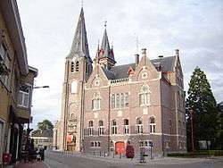 Village centre, with town hall and church of Our Lady | |||
| |||
 Ruiselede Location in Belgium
Location of Ruiselede in West Flanders 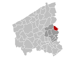 | |||
| Coordinates: 51°02′N 03°23′E / 51.033°N 3.383°ECoordinates: 51°02′N 03°23′E / 51.033°N 3.383°E | |||
| Country | Belgium | ||
| Community | Flemish Community | ||
| Region | Flemish Region | ||
| Province | West Flanders | ||
| Arrondissement | Tielt | ||
| Government | |||
| • Mayor | Greet De Roo | ||
| • Governing party/ies | RKD | ||
| Area | |||
| • Total | 30.20 km2 (11.66 sq mi) | ||
| Population (1 January 2017)[1] | |||
| • Total | 5,395 | ||
| • Density | 180/km2 (460/sq mi) | ||
| Postal codes | 8755 | ||
| Area codes | 051 | ||
| Website | www.ruiselede.be | ||


Ruiselede (historically Ruysselede) is a municipality located in the Belgian province of West Flanders. This town only comprises the town of Ruiselede proper. On January 1, 2006, Ruiselede had a total population of 5,113. The total area is 30.20 km² which gives a population density of 169 inhabitants per km².
Ruiselede was the location of a coastal radio site. From 1923 to 1940 it had a VLF aerial. On 30 December 1933, the mast was demolished when an aircraft collided with it.
References
- ↑ Population per municipality as of 1 January 2017 (XLS; 397 KB)
External links

This article is issued from
Wikipedia.
The text is licensed under Creative Commons - Attribution - Sharealike.
Additional terms may apply for the media files.