Houthulst
| Houthulst | |||
|---|---|---|---|
| Municipality | |||
 Houthulst town hall | |||
| |||
 Houthulst Location in Belgium
Location of Houthulst in West Flanders 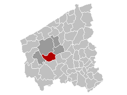 | |||
| Coordinates: 50°59′N 02°57′E / 50.983°N 2.950°ECoordinates: 50°59′N 02°57′E / 50.983°N 2.950°E | |||
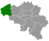
| Country | Belgium | ||
| Community | Flemish Community | ||
| Region | Flemish Region | ||
| Province | West Flanders | ||
| Arrondissement | Diksmuide | ||
| Government | |||
| • Mayor | Ann Vansteenkiste (CD&V) | ||
| • Governing party/ies | CD&V, sp.a Open | ||
| Area | |||
| • Total | 55.89 km2 (21.58 sq mi) | ||
| Population (1 January 2017)[1] | |||
| • Total | 10,028 | ||
| • Density | 180/km2 (460/sq mi) | ||
| Postal codes | 8650 | ||
| Area codes | 051 | ||
| Website | www.houthulst.be | ||


Houthulst (Dutch pronunciation: [ˈɦʌutɦɵlst]) (West Flemish: Outulst) is a municipality located in the Belgian province of West Flanders. The municipality comprises the towns of Houthulst proper, Jonkershove, Klerken and Merkem. On January 1, 2006, Houthulst had a total population of 9,051. The total area is 55.89 km² which gives a population density of 162 inhabitants per km².
Landmarks
- De "Sint-Jan Baptistkerk" (Church of Saint John the Baptist), rebuilt in 1924 after being completely destroyed during World War I.
- The Belgian Military Cemetery, containing the graves of almost 1800 Belgian soldiers, killed during World War I. The cemetery also contains 81 Italian graves. Most of the soldiers who have been buried here were killed during the final assault on the Germans on September 28, 1918, to liberate the Vrijbos forest.
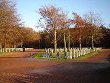
Houthulst - Military Cemetery
References
- ↑ Population per municipality as of 1 January 2017 (XLS; 397 KB)
External links

- Official website - Available only in Dutch
Places adjacent to Houthulst | ||||||||||
|---|---|---|---|---|---|---|---|---|---|---|
| ||||||||||
This article is issued from
Wikipedia.
The text is licensed under Creative Commons - Attribution - Sharealike.
Additional terms may apply for the media files.