Lichtervelde
| Lichtervelde | |||
|---|---|---|---|
| Municipality | |||
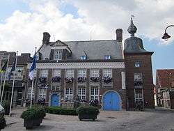 Town hall of Lichtervelde | |||
| |||
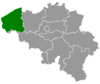
 Lichtervelde Location in Belgium
Location of Lichtervelde in West Flanders  | |||
| Coordinates: 51°02′N 03°08′E / 51.033°N 3.133°ECoordinates: 51°02′N 03°08′E / 51.033°N 3.133°E | |||
| Country | Belgium | ||
| Community | Flemish Community | ||
| Region | Flemish Region | ||
| Province | West Flanders | ||
| Arrondissement | Roeselare | ||
| Government | |||
| • Mayor | Ria Beeusaert-Pattyn | ||
| • Governing party/ies | CD&V | ||
| Area | |||
| • Total | 25.93 km2 (10.01 sq mi) | ||
| Population (1 January 2017)[1] | |||
| • Total | 8,760 | ||
| • Density | 340/km2 (870/sq mi) | ||
| Postal codes | 8810 | ||
| Area codes | 051 | ||
| Website | www.lichtervelde.be | ||


Lichtervelde is a municipality located in the Belgian province of West Flanders. The municipality comprises only the town of Lichtervelde. On January 1, 2006 Lichtervelde had a total population of 8,400. The total area is 25.93 km² which gives a population density of 324 inhabitants per km². The church is 64 m high. In this town the inventor Charles Joseph Van Depoele was born.
 The railway station beginning 20th Century postcard
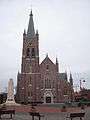 Sint-Jacobus church
 Gustaaf Colpaert, mayor 1927-1932
.png) Lichtervelde station on NMBS
Lichtervelde station on NMBS
References
- ↑ Population per municipality as of 1 January 2017 (XLS; 397 KB)
External links

- Official website - Available only in Dutch
Places adjacent to Lichtervelde | |
|---|---|
This article is issued from
Wikipedia.
The text is licensed under Creative Commons - Attribution - Sharealike.
Additional terms may apply for the media files.