Kortrijk
| Kortrijk | |||
|---|---|---|---|
| Municipality | |||
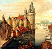
 Broel Towers along the river Lys in Kortrijk | |||
| |||
 Kortrijk Location in Belgium
Location of Kortrijk in West Flanders  | |||
| Coordinates: 50°50′N 03°16′E / 50.833°N 3.267°ECoordinates: 50°50′N 03°16′E / 50.833°N 3.267°E | |||
| Country | Belgium | ||
| Community | Flemish Community | ||
| Region | Flemish Region | ||
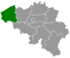
| Province | West Flanders | ||
| Arrondissement | Kortrijk | ||
| Government | |||
| • Mayor | Vincent Van Quickenborne (Open VLD) | ||
| • Governing party/ies | Open VLD, N-VA, sp.a | ||
| Area | |||
| • Total | 80.02 km2 (30.90 sq mi) | ||
| Population (1 January 2017)[1] | |||
| • Total | 75,736 | ||
| • Density | 950/km2 (2,500/sq mi) | ||
| Postal codes | 85xx (8500, 8501, 8510, 8511) | ||
| Area codes | 056 | ||
| Website | www.kortrijk.be | ||
.svg.png)
Kortrijk (in English also Courtrai or Courtray;[2][3] official name in Dutch: Kortrijk, pronounced [ˈkɔrtrɛi̯k]; West Flemish: Kortryk or Kortrik, French: Courtrai, pronounced [kuʁtʁɛ]; Latin: Cortoriacum) is a Belgian city and municipality in the Flemish province of West Flanders.
It is the capital and largest city of the judicial and administrative arrondissement of Kortrijk. The wider municipality comprises the city of Kortrijk proper and the villages of Aalbeke, Bellegem, Bissegem, Heule, Kooigem, Marke, and Rollegem. Kortrijk is also part of the cross-border Lille-Kortrijk-Tournai metropolitan area.[4][5]
The city is on the river Leie, 42 km (26 mi) southwest of Ghent and 25 km (16 mi) northeast of Lille. Mouscron in Wallonia is just south of Kortrijk.[6]

Kortrijk originated from a Gallo-Roman town, Cortoriacum[7], at a crossroads near the Leie river and two Roman roads. In the Middle Ages, Kortrijk grew significantly thanks to the flax and wool industry with France and England and became one of the biggest and richest cities in Flanders. The city is often referred to as City of Groeninge or City of the Golden Spurs, referring to the Battle of Courtrai or the Battle of the Golden Spurs which took place on 11 July 1302 on the Fields of Groeninge in Kortrijk. In 1820, the Treaty of Kortrijk was signed, which laid out the current borders between France and Belgium. Throughout the 19th and 20th century, the flax industry flourished and remains important within the Belgian textile industry today.
Kortrijk is the largest city in southern West Flanders, with several hospitals, colleges and a university. Kortrijk was the first city in Belgium with a pedestrian shopping street, the Korte Steenstraat.
History
Name
The Roman name Cortoriacum[8] meant in latin, the settlement near the curb in the river . There is also mention of Cortoracum in some Litterature. Its name later evolved to Cortrycke, Cortryck, and Kortrijk (19th Century). The French Called it Courtrai.
Origins Roman times
Findings from an archeological digging in 1950 (3 remains of Roman Funeral Pyres were found[9]) seem to indicate that the vicus was used as an encampment/base by the romans during their invasion of Britain in 43ad.
Cortoriacum was a larger Gallo-Roman vicus of civitas Menapiorum at an important crossroads near the Lys river of the Roman roads linking Tongeren and Cassel and Tournai and Oudenburg. It was first mentioned in a document from the 4th or 5th century called Notitia Dignitatum where the Cortoriacenses (Cavalry)Troops were mentioned. In the 9th century, Baldwin II, Count of Flanders established fortifications against the Vikings. The town gained its city charter in 1190 from Philip, Count of Flanders. The population growth required new defensive walls, part of which can still be seen today (the Broeltorens, Armory, Kortrijk). Several local places still refer to physical parts of the Defensive Structures around Kortrijk (Walle, Waterpoort, Menenpoort, Gentsepoort, Brugsepoort, Kasteelkaai); Most of the Physical parts have been overbuilt or destroyed.
In the 13th century, the battles between Fernando of Portugal, Count of Flanders and his first cousin, King Louis VIII of France, led to the destruction of the city. The Counts of Flanders had it rebuilt soon after. To promote industry and weaving in the town, Joan, Countess of Flanders exempted settlers in Kortrijk from property tax.[10] From that time, Kortrijk gained great importance as a centre of linen production.
Battle of the Golden Spurs
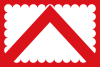
In 1302, the population of Bruges started a successful uprising against the French, who had annexed Flanders a couple of years earlier. On 18 May the French population in that city was massacred, an event that could not go unpunished. The famous ensuing Battle of Courtrai or the Battle of the Golden Spurs (Dutch: Guldensporenslag) between the Flemish people, mostly commoners and farmers, and Philip the Fair’s knights took place near Kortrijk on 11 July, resulting in a victory for Flanders.[11] This date is now remembered as a national holiday by the whole Flemish community.
Following a new uprising by the Flemish in 1323, but this time against their own Count Louis I, the French invaded again. These Flemish acquisitions were consolidated by the French at the Battle of Cassel (1328). Louis I’s son, Louis II, then Philip van Artevelde briefly regained the city in 1381 but lost it again the following year at the Battle of Roosebeke, resulting in a new wave of plundering and destruction.
15th century to modern times
Most of the 15th century was prosperous under the Dukes of Burgundy, until the death of the Burgundian heiress, Mary of Burgundy, in 1482, which ushered in renewed fighting with France.
The 16th century was marked by the confrontations engendered by the Reformation and the uprising of the Netherlands against Spain.
Louis XIV’s reign saw Kortrijk occupied by the French five times in sixty years and its former fortifications razed. The Treaty of Utrecht finally assigned the whole area to Austria.
After the French Revolution and the Napoleonic era, the textile industry, based on flax, and the general economy of the city could finally prosper again.
Kortrijk was heavily bombed in the summer of 1917, but even more damaged by the allied bombing in 1944. The city was an important railway hub for the German army, and for this reason was the target of several allied air-strikes. On 21 July 1944 (the Belgian National Day) around 300 Avro Lancasters dropped over 5,000 bombs on the city centre.[12] Many historical buildings on the central square, as well as the old railway station, were destroyed.
Battles with Reference to Courtrai in Conflicts
Geography

Municipality
After the 1977 fusion the city is made up of:
Neighbouring municipalities
The metropolitan area, including the outer commuter zone, also consists of Kuurne, Wevelgem, Zwevegem and Harelbeke. Although these municipalities have strong morphologic ties with Kortrijk, they aren't officially part of the city.
 Municipalities
|
|
Climate
Kortrijk has an oceanic climate (Köppen Cfb).
| Climate data for Kortrijk (1981–2010 normals, sunshine 1984–2013) | |||||||||||||
|---|---|---|---|---|---|---|---|---|---|---|---|---|---|
| Month | Jan | Feb | Mar | Apr | May | Jun | Jul | Aug | Sep | Oct | Nov | Dec | Year |
| Average high °C (°F) | 6.0 (42.8) |
6.9 (44.4) |
10.7 (51.3) |
14.3 (57.7) |
18.1 (64.6) |
20.7 (69.3) |
23.2 (73.8) |
23.1 (73.6) |
19.6 (67.3) |
15.2 (59.4) |
9.9 (49.8) |
6.4 (43.5) |
14.6 (58.3) |
| Daily mean °C (°F) | 3.5 (38.3) |
3.8 (38.8) |
6.7 (44.1) |
9.4 (48.9) |
13.2 (55.8) |
16.0 (60.8) |
18.2 (64.8) |
18.1 (64.6) |
14.9 (58.8) |
11.2 (52.2) |
7.0 (44.6) |
4.0 (39.2) |
10.5 (50.9) |
| Average low °C (°F) | 0.8 (33.4) |
0.6 (33.1) |
2.8 (37) |
4.5 (40.1) |
8.5 (47.3) |
11.4 (52.5) |
13.5 (56.3) |
13.0 (55.4) |
10.3 (50.5) |
7.3 (45.1) |
4.0 (39.2) |
1.6 (34.9) |
6.6 (43.9) |
| Average precipitation mm (inches) | 70.2 (2.764) |
54.9 (2.161) |
63.6 (2.504) |
50.5 (1.988) |
63.7 (2.508) |
71.9 (2.831) |
76.3 (3.004) |
71.3 (2.807) |
68.4 (2.693) |
77.1 (3.035) |
81.1 (3.193) |
80.1 (3.154) |
829.2 (32.646) |
| Average precipitation days | 12.7 | 10.6 | 12.3 | 9.9 | 11.1 | 10.1 | 10.1 | 9.5 | 10.7 | 11.9 | 13.3 | 13.0 | 135.3 |
| Mean monthly sunshine hours | 59 | 79 | 122 | 177 | 205 | 200 | 214 | 202 | 149 | 119 | 65 | 49 | 1,639 |
| Source: Royal Meteorological Institute[13] | |||||||||||||
Main sights
Architecture
Much of the city's medieval architecture remains intact and is remarkably well preserved and restored. The city centre is one of the largest car-free areas in Belgium. The béguinage, as well as the belfry, were recognized by UNESCO as World Heritage Sites in 1998 and 1999. Interesting highlights are:
Civil
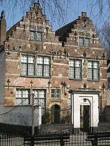
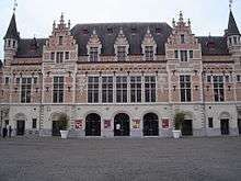
- Medieval City Hall (on the main square, the Grote Markt). The façade of the late-Gothic, early Renaissance city hall is adorned with the statues of the Counts of Flanders.
- The belfry is surmounted by a statue of Mercury, god of the merchants. The belfry is classified by UNESCO as a World Heritage Site.[14]
- Near-identical medieval Broel Towers with the bridge in between that spans the river Leie. (the Speyetower and the Ingelburgtower)
- Artillerytower (Artillerietoren)
- Mont de Piété (Berg van Barmhartigheid or house of Mercy)
- Weigh house (Stadswaag) on the St.Michael-square
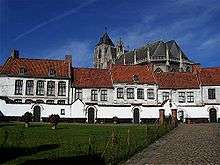
- Our Lady Hospital (Onze-Lieve-Vrouwehospitaal), founded in 1200–1204.
- Baggaertshof, often called Kortrijk's second Beguinage, contains a Botanical garden
- Groeningekouter contains the Groeningegate and the Groeninge Monument, to commemorate the 600th anniversary of the famous Battle of the Golden Spurs
Religious
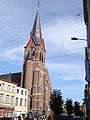
- The Saint-Martin church dates from the 13th century but was mostly rebuilt after a fire in the 15th century. It now houses a 48-bell carillon. Its 83-meter (272 feet) tower remains the highest building in the city.
- The beguinage is one of the quaintest sites in the city. It too, was listed by UNESCO as a World Heritage Site.[15]
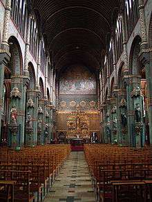
- The church of Our Lady (Onze-Lieve-Vrouwekerk) is former collegiate church. Here the golden spurs taken from the battlefield in 1302 were hung. It houses a rich interior with an altar piece of van Dyck.
- the Count’s chapel (Gravenkapel), built after the example of la Sainte Chapelle in Paris as shrine for Louis II of Flanders.
- Saint-Michaelschurch; a church of the Society of Jesus
- Saint-Johnschurch in the St.-Johnsquarter; a Neo-Gothic basilica
- Groeninge Abbey
- Saint Eligiuschurch
- Saint-Pius X-church
- Saint-Rochchurch
- Saint-Elisabethchurch
- Saint-Anthonychurch or Toontjes kerk with the pilgrimage of Isidore of Saint Joseph
- Saint-Annechurch
- Saint-Theresiachurch
- Father Damienchurch
Museums
Museums in Kortrijk include:
- Kortrijk 1302: seven centuries in one day, a historic museum about the famous Battle of the Golden Spurs, which gave Flanders its official holiday (11 July)
- Broelmuseum (Museum of Fine Arts and archaeological museum), with paintings by Roelant Savery and international Ceramic.
- National Flax Museum in honour of the plant that once was the main driver of Kortrijk’s economy. This museum will be relocated.
- Groeninge Abbey with the Groeningemuseum. This museum gives you an overview of Kortrijk's history.
- Beguinage museum located in the old town, in the béguinage.
- Flemish Film museum and archive
- Bakery- and Millmuseum, located in an old windmill.
- Museum of Agriculture
- International Rose gardens, located in the park of the Castle t Hooghe, in the Hoog-Kortrijk quarter just in front of Kortrijk Xpo.
- Begijnhofmuseum
Transport
Road
Kortrijk lies at the intersection of three highways:
- The E17: connects Kortrijk with Ghent, Sint-Niklaas and Antwerp to the northeast, and with Lille and Paris to the south-west.
- The E403: connects Kortrijk with Bruges and Ostend to the north, and with Tournai, Mons and Charleroi to the south-east.
- The Belgian highway A19: connects Kortrijk with Ypres and the Belgian coast.
- In addition Kortrijk also has two ringways:
Railway
- The municipality of Kortrijk has two railway stations:
- Kortrijk main railway station: an international railway station with direct connections to Brugge Centraal (Bruges), Brussel Zuid, Antwerp, Ghent, Poperinge and Ieper (Ypres), Oudenaarde, other Belgian towns and Lille in France. The station also offers a direct connection to Brussels Airport.
- Bissegem Station: a regional railway station in the village of Bissegem with connections to Ypres.
Public city transport
Kortrijk has an extensive web of public transport lines, operated by De Lijn, providing access to the city centre and the suburbs (city lines, Dutch: stadslijnen) and to many towns and villages in the region around the city (regional lines, Dutch: streeklijnen).
- City buses:
- Line 1: Station – Kortrijk Xpo – Kinepolis – Leiedal
- Line 2: Station – Lange Munte
- Line 4: Station – Bissegem Station – Heule Kransvijver
- Line 50: Station – Kuurne Seizoenswijk
- Line 51: Station – Kuurne Sint-Pieter
- Line 6: Station – Shopping Center (– Industriezone) – Heule Markt
- Line 9: Station – Cederlaan
- Line 12: Station – Kinepolis – Bellegem – Rollegem (– Aalbeke)
- Line 13: Station – Hoog Kortrijk
- Line 80/81: Station – Marke
- Line 91/92/93: Station – Zwevegem
- Regional buses
- At Kortrijk main railway station, there is a bus station where regional buses stop as well.
Airport
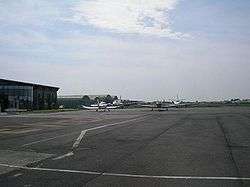
- The city has an airport known as Kortrijk-Wevelgem International Airport, which is mainly used for business travel and medical flights. Kortrijk Airport is located northwest of the citycentre, next to the R8 ringroad.
- The national Brussels Airport, one hour away by train or car, offers the best international connectivity.
- The Lille Lesquin International Airport is located 35 kilometres from Kortrijk.
Waterways

The river Leie is an important way of transporting goods through inland navigation. The Bossuit-Kortrijk Canal enables in the city centre a direct connection with the river Scheldt.
Within the City, the river briefly splits in two, to re-join about a mile further.
- Oude Leie original southernmost riverbed where the Broel towers still stand.
- Nieuwe Leie New bed that was dug around 1585 by Humans to accommodate water powered equipment [16]
From the 1970s on, the planning and later the execution of the so-called Leiewerken (Leieworks) started. These construction works comprised the deepening and widening of the river. This would enable ships with 4400 tons to navigate from France to the Scheldt. At the same time, this project included a thorough urban renewal of the riversides in the city. Seven new bridges were to give a new architectural impulse to the river quarters as well as the construction of several new parks along the river.
The following bridges were built during the period of 1997 and 2012:
- Dambrug
- Groeningebrug near the AlbertPark
- Ronde van Vlaanderenbrug
- Collegebrug referring to the Damian college
- Noordbrug (2010).
- Budabrug
- Reepbrug
More recently (2018), the docks in front of the Broel Towers were lowered to allow the public to enjoy the historic Leie View.
Other Smaller Waterways with Historic and Geological value
Several small streams or Beken in and around Courtrai were of significant topological, historical and Geological value.[17]
- Lange Mere Mentioned in the Town accounts of 1412-13 as Langhe Meere.
- Mosscher (High Mossher and Low Mosscher) ending in the Southern Moat (Sanderus Map[18] mentions only the 'Mosscher as a single toponym. It was also mentioned in almost full length on the Deventer Map[19].
- Groeninghe (first mentioned as Groeninc in 1412 ) Its name came from the green color of the flooded meadow where it originated.
- Grote Vijver (first mention as Hoghen vivere in the town accounts of 1416-17).
- St-Jan's stream - Human Dug connecting stream
- Klakkaert stream
- Moat around the City (south of the Leie or Lys)
- Neveldries
- Bloedmeers
Cycling and pedestrian areas
Cars are required to yield to pedestrians and cyclists. In general, cars are led to large underground car parks in the historic centre of Kortrijk or Park&Ride parking outside the town centre. Large parts of the historic centre are car free.
Economy
The city is historically connected with the flax and the textile industry, and still today the textile industry remains important in the region. Major companies which have headquarters in Kortrijk include Cisco, Barco and Bekaert.
Education
Kortrijk serves as an educational centre in south West Flanders, attracting students from the entire region.
There are 55 schools in Kortrijk, on 72 different locations throughout the city, with an estimated 21,000 students.[20]
The city also provides higher education. The Kortrijk University, the KULAK, a campus of the Catholic University of Leuven, is located in on the south edge of the city, in the Hoog Kortrijk quarter. Other institutes of higher education include the Katholieke Hogeschool Zuid-West-Vlaanderen (KATHO) and Hogeschool West-Vlaanderen (HOWEST) university colleges. There is also a campus of Ghent University.
European cooperation
Even though Kortrijk is a Dutch-speaking town, it borders Wallonia, and is only 9 km (5.6 mi) away from the border with France. This has created an urban area that extends across linguistic and national borders. The mayors of Lille, Kortrijk and Tournai met in Kortrijk on 28 January 2008 to sign a document creating the first European Grouping of Territorial Cooperation within the EU. The purpose of this organisation is to facilitate the movement of people within this area of nearly 2 million people.
- Kortrijk is a member of the Eurotowns network[21]
Culture
Theatres and concert venues
- Kortrijk has several cultural centres, each comprising different locations:
- Cultural Centre Kortrijk
- City Theatre (De Schouwburg, see picture), a neo-Renaissance architecture theatre known for its glass ceiling, an artwork of the French-Algerian artist Alberola
- Arenatheatre
- Antigone Theatre
- Buda Kunstencentrum (Buda Arts Centre), comprising the cinema Budascoop, the artist residence Tacktower and the artist creation space Budafactory
- The Concertstudio
- Music Centre Track*
- Concert venue De Kreun
- Cinemas
- Kinepolis, a modern cinema multiplex with 10 screens.
- Budascoop, a 5 screen cinema, specialised in European movies.
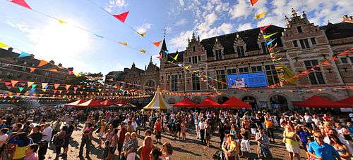
Festivals and events
The city is host to some sizable cultural events such as:
- Day of the Flemish Community (11 July)
- Golden River City Jazz Festival (first weekend of September)
- Humorologie: cabaret festival
- Next: arts festival in the Eurodistrict Kortrijk-Lille-Tournai
- Happy New Ears: festival of experimental modern music
- Budafest: theatre festival
- The Internationaal Festival van Vlaanderen (April–May): several concerts of classical and modern music.
- Novarock: rock festival in Kortrijk Xpo
- Easter Carnival (Paasfoor): during the weeks after Easter
- Sinxenfestival: one of the most vivid festivals downtown with street artists, concerts and flea markets all over town
- Kortrijk Congé (July)
- Summer Carnival (weekend in August)
- Student Welcome Concert: rock festival to celebrate the start of the new academic year at the Kortrijk University and the Kortrijk Colleges.
Also, trade shows and events such as the international Design Fair Interieur, Busworld and the Eurodogshow take place in the Kortrijk Xpo event center. These fairs attract numerous visitors to the city.
In July and August there are various boat tours on the river Leie.
Food
Local specialities include Kalletaart (apple cake with Calvados), Peperbollen, biscuits, and chocolate little beguines. The town of Heule is the home of the Picobrouwerij Alvinne brewery, while Bellegem is the home of the Bockor brewery.
Leisure
Shopping
- Kortrijk was the first town in Belgium to have a fully traffic-free shopping street, the Korte Steenstraat (1962). Later, a lot of neighbouring streets were also made traffic-free. As a result, Kortrijk nowadays has one of the biggest traffic-free areas in Belgium (comprising Lange Steenstraat, Steenpoort, Sint-Jansttraat, Wijngaardstraat and several squares).
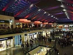
- Kortrijk has several indoor shopping malls including the Ring Shopping Kortrijk Noord, Bouwcentrum Pottelberg and K in Kortrijk (opened March 2010). The latter is in the town centre and which links the main shopping street (Lange Steenstraat) with the Veemarket square. It contains up to 90 stores, including Saturn, H&M, Zara and many other clothes, food and houseware stores.
Parks
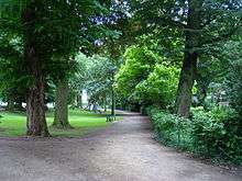
- Beguinagepark
- Groeningepark, on the site of the Groeningekouter where the Battle of Courtrai or the Battle of the Golden Spurs took place. In contains the Groeningegate and the Groeninge Monument
- King Albertpark, with the Leiemonument which commemorates the Battle of the Lys
- Gebroeders van Raemdonckpark
- Queen Astridpark in the Overleie district
- 't Plein, a nineteenth-century park, laid out on a former military site
- Park de Blauwe Poort
- Magdalenapark
- Rozentuin, the International Rose Garden
- Stadsgroen Messeyne
- Kasteelpark Blommeghem
- Kasteelpark 't Hooghe
- Nolfpark
- Stadsgroen Venning, with a butterfly garden
Sports
Football
Kortrijk has three official football clubs.
- K.V. Kortrijk plays in the Belgian First Division A after winning the championship in the former Belgian Second Division during the 2007–2008 season.
- SV Kortrijk plays in the fourth provincial division.
- Wikings Kortrijk is for youth teams.
Basketball
- Kortrijk Sport CB
- Basketbalteam Kortrijk
Cycling
- In Flanders generally, professional cycling is very popular. Many cycling races start, finish or pass through the Kortrijk area. Amongst them are the Driedaagse van West-Vlaanderen, Kuurne–Brussels–Kuurne, Gent–Wevelgem, the Tour of Flanders and Dwars door Vlaanderen. Kortrijk also hosts an after-tour criterium at the start of August called Kortrijk Koerse. Many of the riders who participated in the Tour de France usually appear at the start.
Rugby
- RC Curtrycke[22]
Tennis
- Tennis Club De Egelantier
Swimming
- KZK, Kortrijkse Zwemkring, arguably the best waterpolo team in Belgium, having won the Belgian championship nine times. In the 2007–2008 season they won both the championship and the Belgian cup.
Notable citizens
- Emmanuel de Bethune, former mayor (1987–1989) and (1995–2000)[23]
- Hendrik Beyaert, architect
- Francis Bonaert, architect
- John II of Brienne, Count of Eu
- Carl Colpaert, director, founder of Cineville.com, Inc.
- Hendrik Conscience, writer
- Laurence Courtois, tennis player
- Edmée Daenen, pop artist
- Stefaan De Clerck, politician and former mayor of Kortrijk, former Minister of Justice
- Nico F. Declercq, physicist and professor
- Gustave Léonard de Jonghe, portrait painter
- Jean-Baptiste De Jonghe, landscape painter
- Carl de Keyzer, photographer
- Pierre de La Rue, Renaissance composer
- Sophie de Schaepdrijver, historian
- Vincent de Vos (1829–1875), painter
- Bruno de Witte (1955–), European law Professor, European thinker
- Ann Demeulemeester, fashion designer
- Stijn Devolder, road bicycle racer
- Ernest Gambart, art publisher and dealer
- Guido Gezelle, poet
- Robert Gillon (1884–1972), lawyer, politician
- Piet Goddaer, singer-composer, mostly under the name:Ozark Henry
- Paul Goethals (1832–1901), first Archbishop of Calcutta
- The members of electro rock band Goose
- Leif Hoste, road bicycle racer
- Isidore of Saint Joseph (1881–1916), Passionist brother, beatified by Pope John Paul II in 1984
- Gilles Joye, Franco-Flemish composer of the Renaissance
- Greg LeMond, US professional cyclist – retired
- Xavier Malisse, tennis player
- Morris (1923–2001), cartoonist, creator of Lucky Luke
- Hanne Gaby Odiele, top model
- Tom Omey (b. 1975), middle-distance runner
- Jan Palfyn (1650–1730), doctor, surgeon and inventor of the forceps
- Jean-Jacques Pieters, jazz musician
- Arne Quinze (1971–), designer and conceptual artist
- Jan Robbe (1980–), electronic artist and founder of Entity
- Louis Robbe (1806–1887), painter
- Roelant Savery (1576–1639), painter
- Stijn Streuvels (1871–1969), writer
- Jacobus Vaet, Franco-Flemish composer of the Renaissance
- Guido van Gheluwe (b. 1926), founder of the Orde van den Prince
- Vincent Van Quickenborne (b. 1973), current mayor of the city and former minister of enterprise
- Gella Vandecaveye, judoka, former world champion and Olympic silver medalist
- Emmanuel Viérin (1869–1954), painter
- George Washington, inventor
- Stoffel Vandoorne, Formula 1 racing driver
- Lisa Leysen, Journalist
Town twinning
Kortrijk participates in town twinning to encourage good international relations.[24]


Photo gallery
 The Patriapalace
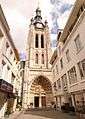 The Saint-Martenstower
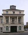 House in Empire style
 The old town (The Gun Powder Tower, De Kruittoren)
 The Groeningegate
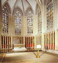 Count's Chapel
 Old houses in the historical city centre
 The Saint-Elooichurch
Notes
- ↑ Population per municipality as of 1 January 2017 (XLS; 397 KB)
- ↑ "Internet site of the town of Izegem". Retrieved 7 September 2011.
- ↑ "An inventory of locations suitable for wind energy in Flanders region". Retrieved 7 September 2011.
- ↑ List of municipalities : http://fr.eurometropolis.eu/qui-sommes-nous/territoire.html
- ↑ "EUROMETROPOLIS : Eurometropolis Lille-Kortrijk-Tournai, the 1st European cross-bordrer metropolis".
- ↑ (in French) Populationdata.net Archived 2008-10-09 at the Wayback Machine., Palmarès des plus grandes villes du monde – page 3]
- ↑ "The Princeton Encyclopedia of Classical Sites, CORTORIACUM (Courtrai) Belgium". Retrieved 2018-06-08.
- ↑ "The Princeton Encyclopedia of Classical Sites, CORTORIACUM (Courtrai) Belgium". Retrieved 2018-06-08.
- ↑ http://www.all-archeo.be/rapporten/217_Kortrijk_Morinnestraat/217%20Rapport%20Kortrijk%20-%20Morinnestraat.pdf
- ↑ Fegley, 124
- ↑ Courtrai (Flem. Kortrijk), a walled town of Belgium, on the Lys, 54 miles SW. of Brussels by rail, and 6 from the French frontier. It has a fine eld bridge flanked with towers, a noble townhall (1526), belfry, and a beautiful Gothic church, founded in 1238 by Baldwin, Count of Flanders. Table damask, linen, and lace are the chief manufactures. Population, about 35,000. Here, in 1302, the citizens of Ghent and Bruges won over the French the 'Battle of the Spurs,' so named from the number of gilt spurs gathered from the dead. Chambers's Concise Gazetteer Of The World, by David Patrick. W. & R. Chambers, Limited, 1906.
- ↑ From De Standaard 17/07/09 Kortrijk is bombardement na 65 jaar nog niet vergeten
- ↑ "Klimaatstatistieken van de Belgische gemeenten" (PDF) (in Dutch). Royal Meteorological Institute. Retrieved 30 May 2018.
- ↑ UNESCO. "Belfries of Belgium and France". Retrieved 2008-01-26.
- ↑ UNESCO. "Flemish Béguinages". Retrieved 2008-01-26.
- ↑ AC02717376, Anonymus (1966). Acta Historiae Neerlandica. Brill Archive. p.11
- ↑ Verbruggen, J. F. (2002). The Battle of the Golden Spurs (Courtrai, 11 July 1302): A Contribution to the History of Flanders' War of Liberation, 1297-1305. Boydell & Brewer. ISBN 978-0-85115-888-4. pp. 135-150
- ↑ Sanderus, Antonius (1586-1664) Cartographe (1600). "Castellaniae Corturiacensis tabula / Ant. Sanderus". Gallica. Retrieved 2018-07-06.
- ↑ Deventer, 1545, Jacob van (2012-09-20), English: Kortrijk, map by Jacob van Deventer, retrieved 2018-07-06
- ↑ "Duurzame Mobiliteit – Stimuleer de opmaak van schoolvervoerplannen". Duurzamemobiliteit.be. Retrieved 2012-02-10.
- ↑ "Eurotowns".
- ↑ "RC Curtrycke".
- ↑ "Kortrijk betreurt het overlijden van haar ere-burgemeester". Kortrijk civic site. 2011. Retrieved 7 November 2011.
- ↑ "071218 Cubelplan 2007–2012" (PDF). Archived from the original (PDF) on October 1, 2011. Retrieved 2012-02-10.
References
- Fegley, R. (2002). The Golden Spurs of Kortrijk: How the Knights of France Fell to the Foot Soldiers of Flanders in 1302, 2007. McFarland and Company Inc.
External links
| Wikivoyage has a travel guide for Kortrijk. |
| Wikimedia Commons has media related to Kortrijk. |
| Wikisource has the text of the 1911 Encyclopædia Britannica article Courtrai. |
- Official website – Information available in Dutch, French, English and German
- Kortrijk airport
- Kortrijk photo gallery
Places adjacent to Kortrijk | |
|---|---|