Tomorr
| Tomorr | |
|---|---|
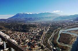 View of Berat and Tomorr covered with snow in the background. | |
| Highest point | |
| Peak | Çuka e Partizanit |
| Elevation | 2,417 m (7,930 ft) [1] |
| Listing | Ultra |
| Coordinates | 40°42′0″N 20°8′0″E / 40.70000°N 20.13333°ECoordinates: 40°42′0″N 20°8′0″E / 40.70000°N 20.13333°E |
| Geography | |
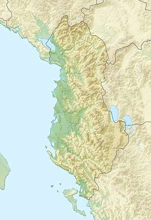 Tomorr Location of Tomorr in Albania | |
| Location | Skrapar, Albania |
| Parent range | Tomorr massif |
| Geology | |
| Mountain type | Limestone |
Mount Tomorr is a mountain in southern Albania, reaching an elevation of 2,417 metres (7,930 ft) above sea level. Tomorr is situated within the Tomorr National Park, which is noted for its diverse species of deciduous and coniferous trees and a great variety of flora.[2] Many endangered species are free to roam and live in this area such as bears (Ursus arctos), wolf (Canis lupus), and birds of prey. Mount Tomorr offers various sports such as hiking, horse or donkey riding, canoeing, and skiing.
History and legend
In the classical period, Mount Tomorr was originally known as Mount Amyron (Greek: Άμυρον); Amyron was a central feature of the region of Dassaretis, which was named after its inhabitants the Dexari, a tribe of Epirus belonging to the Chaonian group of northwestern ancient Greeks.[3]
Mount Tomorr is a sacred site to both Christians, who climb it on Assumption Day (August 15) to honor the Virgin Mary, and the Bektashi, who honor Abbas ibn Ali during an annual pilgrimage on August 20–25.[4]
In Albanian folklore, Mount Tomorr is anthropomorphized and associated with the legendary figure of Baba Tomor, envisioned as an old giant with a long flowing white beard and four female eagles hovering above him and perching on his snow-covered slopes.[4] According to German folklorist Maximilian Lambertz, Baba Tomor is the remnant of an Illyrian deity.[4]
| “ | Baba Tomor has taken the Earthly Beauty to be his bride. She spends her days with her sister, the Sea Beauty, E Bukura e Detit, but when evening comes, the wind, faithful servant of Baba Tomor, carries her back up the mountainside to him. Mount Tomor overlooks the town of Berat, which the old man jealously guards as his favourite city. Across the valley is Mount Shpirag with furrow-like torrents of water running down its slopes. While Baba Tomor was dallying in bed with the Earthy Beauty one day, Shpirag took advantage of the moment and advanced to take over Berat. The four guardian eagles duly awakened Baba Tomor from his dreams. When told of Shpirag's surreptitious plans, Baba Tomor arose from his bed. His first concern was for the safety of the Earthly Beauty and so he ordered the East Wind to carry her back to the home of her sister. Mounting his mule, Tomor then set off to do battle with Shpirag. With his scythe, Tomor lashed into Shpirag, inflicting upon him many a wound which can be seen today as the furrows running down the mountainside. A trace of the hoof of Baba Tomor's mule can, it is said, be seen near the village of Sinja BR. Shpirag, for his part, pounded Tomor with his cudgel and left many a wound on the lofty mountain, but was overcome. The two giants ultimately slew one another and the maiden drowned in her tears, which became the Osum river." | ” |
| — Legend of Baba Tomor[4] | ||
The cult of Mount Tomorr can be found in the Rilindja period of Albanian literature where authors such as Konstantin Kristoforidhi, Naim bey Frashëri, Andon Zako Çajupi, Asdreni, Hilë Mosi, and Ndre Mjeda devoted their works of prose and poetry to Father Tomor.[4]
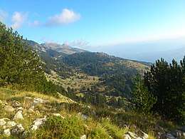 Forests of Tomorr |
.jpg) Bektashi tekke on the peak |
 Osum river and Tomorr in the background |
See also
| Wikimedia Commons has media related to Tomorr. |
References
- ↑ "TREGUES SIPAS QARQEVE INDICATORS BY PREFECTURES" (PDF). Archived from the original (PDF) on 2011-07-24. Retrieved 2010-11-12.
- ↑ "Strategjia Territoriale" (PDF). planifikimi.gov.al (in Albanian). p. 47.
- ↑ Hammond 1994, pp. 422–423; Hammond & Griffith 1972, p. 94.
- 1 2 3 4 5 Elsie 2001, "Tomor, Mount", pp. 252–254.
Sources
- Elsie, Robert (2001). A Dictionary of Albanian Religion, Mythology, and Folk Culture. New York, NY: New York University Press. ISBN 978-0-8147-2214-5.
- Hammond, Nicholas Geoffrey Lemprière; Griffith, Guy Thompson (1972). A History of Macedonia: Historical Geography and Prehistory. I. Oxford, UK: Clarendon Press.
- Hammond, N.G.L. (1994). "9d. Illyrians and North-West Greeks". In Lewis, David Malcolm; Boardman, John. The Cambridge Ancient History, Volume 6: The Fourth Century BC. Cambridge, UK: Cambridge University Press. pp. 422–443. ISBN 0-521-23348-8.