Hurricane Helene (2018)
| Category 2 hurricane (SSHWS/NWS) | |
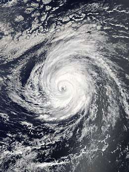 Hurricane Helene at peak intensity west of Cape Verde on September 11 | |
| Formed | September 7, 2018 |
|---|---|
| Dissipated | September 22, 2018 |
| (Extratropical after September 16) | |
| Highest winds |
1-minute sustained: 110 mph (175 km/h) |
| Lowest pressure | 966 mbar (hPa); 28.53 inHg |
| Fatalities | 3 total |
| Damage | Unknown |
| Areas affected | West Africa, Cape Verde, Azores, Ireland, United Kingdom |
| Part of the 2018 Atlantic hurricane season and the 2018–19 European windstorm season | |
Hurricane Helene was one of the easternmost Atlantic hurricanes on record. The eighth named storm and fourth hurricane of the 2018 Atlantic hurricane season, Helene developed from a vigorous tropical wave that moved off the African coast on September 6. The wave was classified as a potential tropical cyclone shortly afterward, and late on September 7 the disturbance organized into a tropical depression while near the coast of Senegal. The depression quickly strengthened into Tropical Storm Helene on the following day. Moving westward toward the Cape Verde Islands, Helene continued to organize, and on September 9 it intensified into a hurricane, the fourth of the 2018 season. The hurricane continued to strengthen as it began a northward turn, and on September 11 it reached its peak intensity as a Category 2 hurricane. Afterward, Helene began weakening as it encountered an increasingly unfavorable environment. Weakening to a tropical storm on September 13, Helene began a gradual extratropical transition as it approached the Azores. Finally, on September 16, Helene became a powerful extratropical cyclone over the northeastern Atlantic Ocean. It weakened considerably as it approached and crossed the United Kingdom, before being absorbed by another system on September 22.
Helene prompted the rare issuance of hurricane watches in the southern Cape Verde Islands, as well as a tropical storm warning, although the storm ultimately passed south of the islands with little adverse effect.
Meteorological history
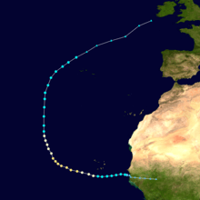
The tropical wave that would eventually spawn Tropical Storm Helene was first mentioned in the National Hurricane Center (NHC)'s Tropical Weather Outlook early on September 5.[1] The wave quickly began to show signs of organization as large bursts of convection flared within the vigorous disturbance. At 15:00 UTC on September 7, the NHC initiated advisories on Potential Tropical Cyclone Eight.[2] Just six hours later, the disturbance developed into a tropical depression.[3] The newly-formed depression continued to rapidly organize, and early on the following day, it strengthened into Tropical Storm Helene.[4] As Helene moved westward to the south of the Cape Verde islands, it continued to organize and intensify. At 21:00 UTC on September 9, Helene became a hurricane while positioned 145 miles (230 kilometers) south of Cape Verde.[5] Upon designation as a hurricane at 13°54′N 27°12′W / 13.9°N 27.2°W,[6] Helene became the second-easternmost hurricane to form in the tropical Atlantic in the satellite era, behind only 2015's Hurricane Fred.[7] Moving westward, Helene continued to intensify, becoming a Category 2 hurricane at 15:00 UTC on September 10.[8] At 03:00 UTC on September 11, Helene reached its peak intensity as a high-end Category 2 hurricane with maximum sustained winds of 110 mph (175 km/h).[9] Helene held its peak intensity for eighteen hours, before turning northward into an increasingly unfavorable environment.
Weakening to a tropical storm on September 13, Helene continued northward, while beginning a gradual northeastward turn toward the Azores.[10] From September 13–14, Helene interacted with the smaller Tropical Storm Joyce to the west, due to the Fujiwhara effect, steering Joyce counter-clockwise around the larger system.[11] By early on September 14, the storm's cloud pattern began to resemble an extratropical cyclone, as Helene's windfield expanded and its forward speed increased. However, a phase diagram revealed that Helene still possessed a warm core, and was thus still a tropical cyclone.[12] Very early on September 16, Helene made its closest approach to the Azores, passing just 65 mi (105 km) north-northwest of Flores Island.[13] As it moved away from the Azores, Helene's cloud pattern continued to deteriorate, and by 15:00 UTC, it had completed its transition to an extratropical cyclone, as it moved swiftly northeastward.[14] On the same day, Helene become the first named storm of the 2018–19 European windstorm season.[15]
On September 18, Helene moved across the northern periphery of Ireland,[16] before drifting into the Norwegian Sea.[17] On September 22, Helene's remnant was absorbed into another extratropical storm approaching from the southwest.[18]
Preparations and impact
The tropical wave that spawned Helene produced heavy rainfall in Guinea, triggering flooding that killed 3 people in Doko.[19] There were no reports of damage or fatalities elsewhere in Africa.
Upon the classification of Helene as a potential tropical cyclone, the Government of Cape Verde issued a tropical storm warning for the islands of Santiago, Fogo, and Brava.[1] A hurricane watch was issued for the same islands early on the following day, with Helene then expected to become a hurricane before impacting the islands.[20] However, Helene ultimately passed south of the islands with minimal effect.
As a post-tropical cyclone, Helene brought winds of gale-force to parts of the British Isles. The Met Office of the United Kingdom issued yellow wind warnings for southern England, the Midlands and Wales for the night of September 17–18.[21] [22] However, Helene weakened considerably as it approached the British Isles, with winds gusting to only 50 mph (85 km/h) in isolated locations. As a result, all warnings were cancelled on September 18 while Helene continued its trek across the British Isles. There were no reports of damage or fatalities as a result of Helene in the United Kingdom and Ireland.
See also
- Other tropical cyclones named Helene
- Hurricane Debbie (1961) – Moved through the Cape Verde Islands as a tropical storm, becoming a hurricane shortly afterward.
- Hurricane Fred (2015) – Easternmost Atlantic hurricane on record to form in the tropics; affected Cape Verde as a Category 1 hurricane.
- Hurricane Ophelia (2017) – Affected the Azores and British Isles less than a year earlier.
References
- 1 2 Eric S. Blake (September 5, 2018). NHC Graphical Tropical Weather Outlook Archive (Report). Miami, Florida: National Hurricane Center. Retrieved September 8, 2018.
- ↑ Michael J. Brennan (September 7, 2018). Potential Tropical Cyclone Eight Advisory Number 1 (Report). Miami, Florida: National Hurricane Center. Retrieved September 8, 2018.
- ↑ Jack L. Beven (September 7, 2018). Tropical Depression Eight Advisory Number 2 (Report). Miami, Florida: National Hurricane Center. Retrieved September 8, 2018.
- ↑ Lixion Avila (September 8, 2018). Tropical Storm Helene Advisory Number 3 (Report). Miami, Florida: National Hurricane Center.
- ↑ Richard Pasch (September 9, 2018). Hurricane Helene Advisory Number 10 (Report). Miami, Florida: National Hurricane Center.
- ↑ "Hurricane Helene Advisory Number 11". www.nhc.noaa.gov. Retrieved 2018-09-09.
- ↑ Philip Klotzbach [@philklotzbach] (9 September 2018). "Helene now has max winds of 85 mph at 27.2°W. In the satellite era (since 1966), the only Atlantic hurricane further east to be this strong in the tropics (south of 23.5°N) is Fred (2015)" (Tweet). Retrieved 10 September 2018 – via Twitter.
- ↑ Michael J. Brennan (September 10, 2018). Hurricane Helene Tropical Cyclone Update (Report). Miami, Florida: National Hurricane Center. Retrieved September 16, 2018.
- ↑ John P. Cangialosi (September 11, 2018). "Hurricane Helene Advisory Number 15". Retrieved September 16, 2018.
- ↑ Christopher Landsea (September 13, 2018). "Hurricane Helene Advisory Number 25". Retrieved September 16, 2018.
- ↑ Daniel Brown (September 14, 2018). "Tropical Storm Joyce Discussion Number 7". Miami, Florida: National Hurricane Center. Retrieved September 18, 2018.
- ↑ David Zelinsky (September 14, 2018). "Hurricane Helene Discussion Number 28". Retrieved September 16, 2018.
- ↑ Lixion Avila (September 16, 2018). "Hurricane Helene Intermediate Advisory Number 34".
- ↑ Daniel P. Brown (September 16, 2018). "Post-Tropical Cyclone Helene Discussion Number 37". Retrieved September 17, 2018.
- ↑ "Met Éireann briefing on Ex Tropical Storm Helene 4pm Monday 17th September – Met Éireann – The Irish Meteorological Service". www.met.ie. Met Éireann. 17 September 2018. Retrieved 17 September 2018.
- ↑ "Europe Weather Analysis on 2018-9-18". Free University of Berlin. September 18, 2018. Retrieved September 24, 2018.
- ↑ "Europe Weather Analysis on 2018-9-21". Free University of Berlin. September 21, 2018. Retrieved September 24, 2018.
- ↑ "Europe Weather Analysis on 2018-9-22". Free University of Berlin. September 22, 2018. Retrieved September 24, 2018.
- ↑ Mohamed Moro Sacko (September 6, 2018). "Siguiri : Trois morts suite à des pluies duliviennnes à Doko" (in French). Guinea News. Retrieved September 8, 2018.
- ↑ David Zelinsky; Daniel P. Brown (September 8, 2018). Tropical Storm Helene Tropical Cyclone Update (Report). Miami, Florida: National Hurricane Center.
- ↑ "Met Éireann briefing on Ex Tropical Storm Helene 4pm Monday 17th September – Met Éireann – The Irish Meteorological Service". www.met.ie. Met Éireann. 17 September 2018. Retrieved 17 September 2018.
- ↑ "Will Tropical Storm Helene affect the UK?". Met Office. 14 September 2018. Retrieved 14 September 2018.