Thames Estuary
Coordinates: wiki 51°30′N 0°35′E / 51.500°N 0.583°E
.jpg)
.jpg)
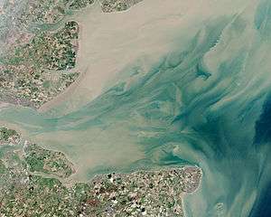
The Thames Estuary is where the River Thames meets the waters of the North Sea, in the south-east of Great Britain.
The limits of the estuary have been defined in several ways:[1]
- Although physically the head of Sea Reach or the Kent / Essex Strait, south of Canvey Island on the northern (Essex) shore presents a western boundary, the Tideway itself can be considered estuarine; it starts in south-west London at Teddington/Ham.
- The Yantlet Line between the Crowstone in Chalkwell and the London Stone on the Isle of Grain.
- The Nore sandbank between Havengore Creek, Essex, and Warden Point, Kent.
- The eastern boundary of the estuary suggested in a Hydrological Survey of 1882-9 is a line drawn from North Foreland, Margate, Kent via the Kentish Knock lighthouse to Harwich in Essex. It is to this line that the typical estuarine sandbanks extend.[2] The estuary downstream of the Tideway has a tidal movement of 4 metres, moving at a speed of up to 2.6 knots (4.8 km/h; 3.0 mph).[3]
- A line from Warden Point on the Isle of Sheppey Kent via Sea Reach No. 1 buoys to Havengore Head Essex.
The estuary is one of the largest of 170 such inlets on the coast of Great Britain. It constitutes a major shipping route: its thousands of movements each year include large oil tankers, container ships, bulk carriers and roll-on/roll-off (ro-ro) ferries entering the estuary for the Port of London and the Medway Ports of Sheerness, Chatham and Thamesport.
The traditional Thames sailing barge worked in this area, designed to be suitable for the shallow waters in the smaller ports. More recently one of the largest wind farms in the UK has been developed in the estuary, located 8.5 km north of Herne Bay, Kent. The farm contains 30 wind turbines generating a total of 82.4MW of electricity. The much larger 630 MW London Array was inaugurated in 2013.
This area has had several proposed sites for the building of a new airport to supplement, or even to replace Heathrow/Gatwick. In the 1960s Maplin Sands was a contender; in 2002 it was to be at Cliffe, Kent. The new airport would be built on a man-made island in the estuary north of Minster-in-Sheppey [4] There is also some discussion about the need for a Lower Thames Crossing in order to alleviate traffic congestion at Dartford.
The Thames Estuary is the focal part of the 21st-century toponym, the "Thames Gateway", designated as one of the principal development areas in Southern England.
Greater Thames Estuary
The appellation Greater Thames Estuary[5] applies to the coast and the low-lying lands bordering the estuary itself. These are characterised by the presence of mudflats, low-lying open beaches and salt marshes, namely the North Kent Marshes and the Essex Marshes. Man-made embankments are backed by reclaimed wetland grazing areas, but rising sea levels may make it necessary to temporarily flood some of that land in places at spring tides, to take the pressure off the defences.
There are many smaller estuaries in Essex, including the Rivers Colne, Blackwater and Crouch. Small coastal villages depend on an economy of fishing, boat-building, and yachting.[6] The Isle of Sheppey, the Isle of Grain, Canvey Island, Two Tree Island, Havengore Island, New England Island, Rushley Island, Potton Island, Foulness Island and Mersea Island are part of the coastline.[7]
Where higher land reaches the coast there are some larger settlements, such as Clacton-on-Sea to the north in Essex, Herne Bay, Kent, and the Southend-on-Sea area within the narrower part of the estuary
Salinity
| Designations | |
|---|---|
| Official name | Thames Estuary and Marshes |
| Designated | 5 May 2000 |
| Reference no. | 1025[8] |
The River Thames flowing through London is a classic river estuary, with sedimentary deposition restricted through manmade embankments. The district of Teddington a few miles south-west of London's centre marks the boundary between the tidal and non-tidal parts of the Thames, although it is still considered a freshwater river about as far east as Battersea insofar as the average salinity is very low and the fish fauna consists predominantly of freshwater species such as roach, dace, carp, perch, and pike. The Thames Estuary becomes brackish between Battersea and Gravesend, and the diversity of freshwater fish species present is smaller, primarily roach and dace, euryhaline marine species such as flounder, European seabass, mullet, and smelt become much more common. Further east, the salinity increases and the freshwater fish species are completely replaced by euryhaline marine ones, until the river reaches Gravesend, at which point conditions become fully marine and the fish fauna resembles that of the adjacent North Sea and includes both euryhaline and stenohaline marine species. A similar pattern of replacement can be observed with the aquatic plants and invertebrates living in the river.[9][10]
Cultural references
Joseph Conrad lived in Stanford-le-Hope close to the Essex marshes. His The Mirror of the Sea (1906) contains a memorable description of the area as seen from the Thames. It is also described in the first pages of Conrad's Heart of Darkness, as both the launching place of England's great ships of exploration and colonization and, in ancient times, the site of colonization of the British Isles by the Roman Empire.
- Accent
The form of speech of many of the people of the area, principally the accents of those from Kent and Essex, is often known as Estuary English. The term is a term for a milder variety of the "London Accent". The spread of Estuary English extends many hundreds of miles outside London and all of the neighbouring home counties around London have residents who moved from London and brought their version of London accents with them leading to interference with the established local accents. The term London Accent is generally avoided as it can have many meanings. Forms of "Estuary English" as a hybrid between Received pronunciation and various London accents can be heard in all of the New Towns, all of the coastal resorts and in the larger cities and towns along the Thames Estuary.
Channels
For commercial shipping approaching the Nore and thus London, main deep-water routes were the Princes Channel, the Queens Channel and the South Channel to the south, to a lesser extent the Kings Channel and the Swin to the north. The Swin was used by barges and leisure craft from the Essex rivers, and coasters and colliers from the north east. These channels were made up of natural troughs; Yantlet Channel (Sea Reach), Oaze Deep, Knock John Channel, Black Deep Channel which have been extensively marked. These are separated by slow moving sandbanks with names such as the East and West Barrows, the Nob, the Knock, the John, the Sunk, the Girdler, and the Long sands. [11]
The shallow bottomed barges and coasters would navigate the swatchways at flood tide, an would cross the sand banks at spitways, points where the water was least shallow, and just deep enough at that point of the tide. If they missed the moment they would heave to and wait for the next tide.
Recreational craft are expected use channels most suited to the size of their vessel. When navigating to or from the north they should use the Middle Deep, Swin and Warp. Barrow Deep and Warp. When navigating to or from the south, they should use the Horse and Gore and Four Fathom Channels.
To cross the estuary large vessels used Fisherman’s Gat, and small vessels to were expected to use Foulger’s Gat.[12]
Navigational marks
This table shows, from west to east, the principal navigation lights, buoys and other marks to the north (port) and south (starboard) of the main deep-water channels of the River Thames from Gallions Reach to the Sunk Light Float.[13][14][15][16][17] The Thames is in IALA region A so port buoys are red and starboard buoys are green.
Thames estuary navigation marks
| Name of navigational mark | South of channel | Channel | North of channel | ||||
|---|---|---|---|---|---|---|---|
| Type | Light | Location coordinate | Type | Light | Location coordinate | ||
| Margaretness Point (or Tripcock Ness) Light | Lighthouse | Group flashing (2) white 5s | 51°30.662′N 0°05.766′E / 51.511033°N 0.096100°E | Gallions Reach / Barking Reach | ̶ | ̶ | ̶ |
| Crossness Point Light | Lighthouse | Flashing white 5s | 51°30.920′N 0°07.990′E / 51.515333°N 0.133167°E | Barking Reach / Halfway Reach | ̶ | ̶ | ̶ |
| Crayfordness Point Light | Lighthouse | Flashing white 5s + fixed | 51°28.689′N 0°13.000′E / 51.478150°N 0.216667°E | Erith Rands / Long Reach | ̶ | ̶ | ̶ |
| Stone Ness Light | ̶ | ̶ | ̶ | Long Reach / St Clement's Reach | Lighthouse | Flashing green 2.5s | 51°27.9167′N 0°16.8231′E / 51.4652783°N 0.2803850°E |
| Broadness Point Light | Lighthouse | Occulting red 5s | 51°27.878′N 0°18.900′E / 51.464633°N 0.315000°E | St Clement's or Fiddler's Reach / Northfleet Hope | ̶ | ̶ | ̶ |
| Tilbury Warning Light | ̶ | ̶ | ̶ | Gravesend Reach | Warning light, vessels manoeuvring at Tilbury | Isophase 6s | 51°27.000′N 0°21.340′E / 51.450000°N 0.355667°E |
| Shornmead Light | Lighthouse | Group flashing (2) white, red 10s | 51°26.983′N 0°26.533′E / 51.449717°N 0.442217°E | Gravesend Reach / The Lower Hope | ̶ | ̶ | |
| Ovens | ̶ | ̶ | ̶ | The Lower Hope | Quick flashing green | 51°27.493′N 0°26.355′E / 51.458217°N 0.439250°E | |
| Haven Traffic Warning Lights | Warning light, vessels manoeuvring at Coryton | E | 51°27.90′N 0°30.10′E / 51.46500°N 0.50167°E | The Lower Hope / Sea Reach | Warning light, vessels manoeuvring at Coryton | White | 51°30.50′N 0°31.65′E / 51.50833°N 0.52750°E |
| London Gateway | ̶ | ̶ | ̶ | Sea Reach | Buoy | 51°30.30′N 0°28.20′E / 51.50500°N 0.47000°E | |
| Sea Reach No. 7 | Port buoy
Racon T |
Flashing Red 2.5s | 51°30.011′N 0°36.908′E / 51.500183°N 0.615133°E | The Yantlet Channel | Yellow pillar buoy | Flashing yellow 2.5s | 51°30.206′N 0°36.938′E / 51.503433°N 0.615633°E |
| Sea Reach No. 6 | Port buoy | Flashing red 5s | 51°29.932′N 0°39.839′E / 51.498867°N 0.663983°E | Starboard buoy | Flashing green 5s | 51°30.126′N 0°39.867′E / 51.502100°N 0.664450°E | |
| Sea Reach No. 5 | Port buoy | Very quick flashing red | 51°29.848′N 0°41.426′E / 51.497467°N 0.690433°E | Starboard buoy | Very quick flashing Green | 51°30.041′N 0°41.473′E / 51.500683°N 0.691217°E | |
| Sea Reach No. 4 | Port buoy | Group flashing (2) red 5s | 51°29.504′N 0°44.121′E / 51.491733°N 0.735350°E | Starboard buoy | Group flashing (2) green 5s | 51°29.694′N 0°44.193′E / 51.494900°N 0.736550°E | |
| Sea Reach No. 3 | Port buoy | Quick flashing red | 51°29.221′N 0°46.707′E / 51.487017°N 0.778450°E | Starboard buoy | Quick flashing green | 51°29.410′N 0°47.061′E / 51.490167°N 0.784350°E | |
| Sea Reach No. 2 | Port buoy | Flashing red 5s | 51°29.296′N 0°49.754′E / 51.488267°N 0.829233°E | Starboard buoy | Flashing green 5s | 51°29.493′N 0°49.726′E / 51.491550°N 0.828767°E | |
| Sea Reach No. 1 | Port buoy | Flashing red 2.5s | 51°29.368′N 0°52.445′E / 51.489467°N 0.874083°E | Yellow pillar buoy
Racon T |
Flashing yellow 2.5s | 51°29.586′N 0°52.710′E / 51.493100°N 0.878500°E | |
| West Oaze | ̶ | ̶ | ̶ | The Oaze Deep | Red & white buoy | Isophase 5s | 51°28.975′N 0°55.413′E / 51.482917°N 0.923550°E |
| Oaze Bank | ̶ | ̶ | ̶ | Starboard buoy | Quick flashing green | ||
| Oaze | Yellow pillar buoy | Group flashing (4) Yellow 10s | 51°28.977′N 0°56.917′E / 51.482950°N 0.948617°E | ̶ | ̶ | ̶ | |
| Argus | ̶ | ̶ | ̶ | Yellow pillar buoy yellow ‘X’ topmark | Flashing yellow 2.5s | 51°29.297′N 0°58.715′E / 51.488283°N 0.978583°E | |
| Oaze Deep | ̶ | ̶ | ̶ | Starboard buoy | Group flashing (2) green 5s | 51°30.000′N 1°0.000′E / 51.500000°N 1.000000°E | |
| Knob | Red & white buoy | Isophase 5s | ̶ | ̶ | ̶ | ||
| SE Mouse | ̶ | ̶ | ̶ | Starboard buoy | Quick flashing green | ||
| Knock John No. 7 | ̶ | ̶ | ̶ | The Knock John Channel | Starboard buoy | Group flashing (4) green 15s | 51°31.956′N 1°06.406′E / 51.532600°N 1.106767°E |
| Knock John No. 5 | ̶ | ̶ | ̶ | Starboard buoy | Group flashing (3) green 10s | 51°32.490′N 1°07.750′E / 51.541500°N 1.129167°E | |
| Knock John No. 4 | Port buoy | Group flashing (3) red 10s | 51°32.323′N 1°07.906′E / 51.538717°N 1.131767°E | ̶ | ̶ | ̶ | |
| Knock John No. 3 | ̶ | ̶ | ̶ | Starboard buoy | Flashing green 5s | 51°33.278′N 1°09.692′E / 51.554633°N 1.161533°E | |
| Knock John No. 2 | Port buoy | Flashing red 5s | 51°33.112′N 1°09.847′E / 51.551867°N 1.164117°E | ̶ | ̶ | ̶ | |
| Knock John No. 1 | ̶ | ̶ | ̶ | South cardinal buoy | Quick flashing white (6) + long flash 15s | 51°33.717′N 1°10.833′E / 51.561950°N 1.180550°E | |
| Knock John | Port buoy | Group flashing (2) red 5s | 51°33.661′N 1°11.357′E / 51.561017°N 1.189283°E | ̶ | ̶ | ̶ | |
| Black Deep No. 12 | Port buoy | Group flashing (4) red 15s | 51°33.661′N 1°13.511′E / 51.561017°N 1.225183°E | The Black Deep Channel | ̶ | ̶ | ̶ |
| Black Deep No. 11 | ̶ | ̶ | ̶ | Starboard buoy | Group flashing (3) green 10s | 51°34.250′N 1°13.475′E / 51.570833°N 1.224583°E | |
| Black Deep No. 10 | Port buoy | Group flashing (3) red 10s | ̶ | ̶ | ̶ | ||
| Black Deep No. 9 | ̶ | ̶ | ̶ | South cardinal buoy | Quick flashing white (6) + long flash | ||
| Inner Fisherman | Port buoy | Quick flashing red | ̶ | ̶ | ̶ | ||
| Black Deep No. 7 | ̶ | ̶ | ̶ | Starboard buoy | Quick flashing green | ||
| Black Deep No. 8 | ̶ | ̶ | ̶ | West cardinal buoy | Quick flashing white (9) 15s | ||
| BDM2 | Yellow pillar buoy (mid-channel) | Flashing yellow 2.5s | 51°37.370′N 1°20.040′E / 51.622833°N 1.334000°E | ̶ | ̶ | ̶ | |
| Black Deep No. 6 | Port buoy | Flashing red 2.5s | ̶ | ̶ | ̶ | ||
| Black Deep No. 5 | ̶ | ̶ | ̶ | East cardinal buoy | Very quick flashing white (3) 5s | ||
| Black Deep No. 4 | Port buoy | Group flashing (2) red 5s | ̶ | ̶ | ̶ | ||
| BDM1 | Yellow pillar buoy (mid-channel) yellow ‘X’ topmark | Flashing yellow 2.5s | 51°41.960′N 1°27.590′E / 51.699333°N 1.459833°E | ̶ | ̶ | ̶ | |
| Black Deep No. 3 | ̶ | ̶ | ̶ | Starboard buoy | Group flashing (3) green 15s | ||
| Black Deep No. 1 | ̶ | ̶ | ̶ | Starboard buoy | Flashing green 5s | ||
| Black Deep No. 2 | Port buoy | Group flashing (4) red 15s | ̶ | ̶ | ̶ | ||
| SHM | Yellow pillar buoy (mid-channel) yellow ‘X’ topmark Racon T | Flashing yellow 2.5s | 51°46.050′N 1°31.540′E / 51.767500°N 1.525667°E | ̶ | ̶ | ̶ | |
| Sunk Head Tower | ̶ | ̶ | ̶ | North cardinal buoy | Quick flashing white | ||
| Black Deep | Port buoy | Quick flashing red | 51°48.10′N 1°36.60′E / 51.80167°N 1.61000°E | ̶ | ̶ | ̶ | |
| Trinity | South cardinal buoy | Quick flashing (6) + long flash 15s | ̶ | ̶ | ̶ | ||
| Dynamo | ̶ | ̶ | ̶ | Yellow pillar buoy yellow ‘X’ topmark | Flashing yellow 2.5s | 51°50.060′N 1°33.880′E / 51.834333°N 1.564667°E | |
| Sunk Inner | ̶ | ̶ | ̶ | Light float | Isophase 3s | 51°51.170′N 1°34.400′E / 51.852833°N 1.573333°E | |
References
Notes
- ↑ "81. Greater Thames Estuary". Countryside Agency. Archived from the original on 27 February 2006. Retrieved 2 March 2013.
- ↑ "Thames Estuary Passages" (PDF). the Cruising Almanac. Archived from the original (PDF) on 29 February 2008. Retrieved 2 March 2013.
- ↑ 2100.1 Thames Estuary South (chart), St Ives: Imray, Laurie, Norie & Wilson Ltd, February 2018 . Tidal diamond "F" in West Swin
- ↑ "The Thames Estuary Airport Ltd". Teaco.co.uk. Retrieved 2012-03-18.
- ↑ "The Thames Estuary Partnership". Thamesweb.com. 2012-02-07. Retrieved 2012-03-18.
- ↑ "English Nature and the Greater Thames Estuary". English-nature.org.uk. Retrieved 2012-03-18.
- ↑ Ordnance Survey, Landranger map 178: The Thames Estuary (2016)
- ↑ "Thames Estuary and Marshes". Ramsar Sites Information Service. Retrieved 25 April 2018.
- ↑ The River Thames - its geology, geography and vital statistics from source to sea, The-River-Thames.co.uk
- ↑ The River Thames - its natural history The-River-Thames.co.uk
- ↑ Eade, John. "Estuary - WHERE THAMES SMOOTH WATERS GLIDE". thames.me.uk. Retrieved 27 June 2018.
- ↑ "Recreational Users Guide" (PDF). Retrieved 27 June 2018.
- ↑ Admiralty Chart 2484 - River Thames Hole Haven to London Bridge (2013)
- ↑ Admiralty Chart 1185 - River Thames Sea Reach (2017)
- ↑ Admiralty Chart 1183 - Thames Estuary (2017)
- ↑ Crossing the Thames Estuary by Roger Gaspar (Imray)
- ↑ "Mariners' passage planning and routeing guide" (PDF).