Operational Land Imager
The Operational Land Imager (OLI) is a remote sensing instrument aboard Landsat 8, built by Ball Aerospace & Technologies. Landsat 8 is the successor to Landsat 7 and was launched in 2013.[1]
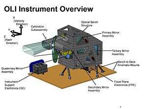
OLI is a push broom scanner that uses a four-mirror telescope with fixed mirrors.
Overview and mission
OLI operates alongside TIRS (Thermal Infrared Sensor) onboard the LDCM.[2] The build and design of OLI differs from previous generations of instruments, while still maintaining data continuity with archived Landsat data from the last 40 years by keeping the same spectral and spatial resolutions of previous instruments.
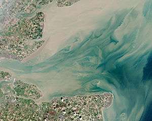
OLI aids the Landsat-8 mission in the imaging of Earth's surface and the collection of moderate resolution data that is used to monitor changing trends on the surface and evaluate how land usage changes over time. The images and data that OLI has helped collect have practical applications today in agriculture, mapping, and monitoring changes in snow, ice, and water.[3]
Specifications and design
OLI is a pushbroom sensor that operates in the visible (VIS) and short wave infrared (SWIR) spectral regions.[4] It has a swath width of 185-kilometer (115 mi), which means it can image the entire Earth over a repeating cycle of 16 days.[5] OLI uses nine channels, which range from wavelengths of 443 nm to 2,200 nm. Of these nine channels, eight are multispectral and one is panchromatic. The eight multispectral channels have a 30-meter (98 ft) spatial resolution, and the panchromatic channel has a spatial resolution of 15 meters (49 ft).[4]
| Spectral Band | Wavelength | Resolution |
|---|---|---|
| Band 1 – Coastal / Aerosol | 0.433–0.453 µm | 30 m |
| Band 2 – Blue | 0.450–0.515 µm | 30 m |
| Band 3 – Green | 0.525–0.600 µm | 30 m |
| Band 4 – Red | 0.630–0.680 µm | 30 m |
| Band 5 – Near infrared | 0.845–0.885 µm | 30 m |
| Band 6 – Short-wavelength infrared | 1.560–1.660 µm | 30 m |
| Band 7 – Short-wavelength infrared | 2.100–2.300 µm | 30 m |
| Band 8 – Panchromatic | 0.500–0.680 µm | 15 m |
| Band 9 – Cirrus | 1.360–1.390 µm | 30 m |
While the spectral and spatial resolution of OLI's channels were kept the same as prior instruments in order to maintain data continuity with the entire Landsat archive, two spectral bands (the first a blue visible channel and the second an infrared channel) were added.[3] These bands were designated as band 1 and band 9, and serve as an enhancement from previous instruments, which lacked these channels. Band 1 was created to locate and determine water resources and investigate coastal areas, and band 9 serves a unique purpose of detecting cirrus clouds.[2]
Applications
OLI has several different applications due to the many different bands. Band 1 is helpful in imaging shallow water resources and tracking aerosols. Bands 2, 3, and 4 are in the visible spectrum and are helpful in creating true color composite images. Band 5 is helpful for ecology purposes and can help determine vegetation index or NDVI. Bands 6 and 7 are useful in geology and can help in distinguishing different saturated and unsaturated rocks and soils. Band 8 is helpful in creating images with very high resolution and precision. Band 9 is used for detecting different types of clouds.[7]
References
- ↑ Gerace, Aaron D.; Schott, John R.; Nevins, Robert (January 2013). "Increased potential to monitor water quality in the near-shore environment with Landsat's next-generation satellite". Journal of Applied Remote Sensing. 7. Bibcode:2013JARS....7.3558G. doi:10.1117/1.JRS.7.073558. 073558.
- 1 2 "Landsat 8 OLI (Operational Land Imager) and TIRS (Thermal Infrared Sensor)". Long Term Archive. U.S. Geological Survey. Retrieved 22 March 2018.
- 1 2 Knight, Edward J.; Kvaran, Geir (October 2014). "Landsat-8 Operational Land Imager Design, Characterization and Performance". Remote Sensing. 6 (11): 10286–10305. Bibcode:2014RemS....610286K. doi:10.3390/rs61110286.
- 1 2 Murphy-Morris, Jeanine (8 January 2008). "Operational Land Imager" (PDF). U.S. Geological Survey.
- ↑ "Operational Land Imager". Ball Aerospace. Retrieved 2018-03-22.
- ↑ "Landsat Data Continuity Mission" (PDF). NASA/U.S. Geological Survey. 2010. NP-2010-11-182-GSFC. Retrieved 12 February 2013.
- ↑ "Landsat 8 Bands". Landsat Science. NASA/GSFC. Retrieved 22 March 2018.
Further reading
- Knight, Edward J.; Canova, Brent; Donley, Eric; Kvaran, Geir; Lee, Kenton (2011). The Operational Land Imager: Overview and Performance (PDF). 2011 Civil Commercial Imagery Evaluation Workshop. 29-31 March 2011. Boulder, Colorado.
External links
- Operational Land Imager at Ball.com
- Operational Land Imager at NASA.gov