Tahirpur Upazila
| Tahirpur তাহিরপুর | |
|---|---|
 | |
| Division | Sylhet Division |
| District | Sunamganj District |
| Government | |
| • MP (Sunamganj-1) | Moazzem Hossain Ratan (Awami League) |
| Area | |
| • Total | 313.7 km2 (121.1 sq mi) |
| Population | |
| • Total | 155,188 |
| • Density | 490/km2 (1,300/sq mi) |
| Time zone | UTC+6 (BST) |
| Postal code | 3030 |
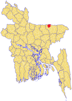
Tahirpur (Bengali: তাহিরপুর) is an upazila of Sunamganj District in the division of Sylhet, Bangladesh.[1]
Geography
Tahirpur is located at 25°05′30″N 91°10′30″E / 25.0917°N 91.1750°E. With and area of 313.70 km2, it is bounded by the Indian state of Meghalaya to the north, Jamalganj and Dharmapasha Upazilas on the south, Bishwambarpur Upazila on the east, and Dharmapasha Upazila on the west.
Demographics
Tahirpur Upazila contains about 22,000 households, with a total population of about 155,000, with a sex ratio of about 51.9% male to 48.1% female. The population is overwhelmingly Muslim, with about 9.8% Hindu, and less than 0.5% other religions.
Administration Tahirpur Thana, now an upazila, was formed in 1924.
| Name & GO Code | Area(km2) | Population | Male | Female | Density | Literacy rate |
|---|---|---|---|---|---|---|
| Uttar Bardal 82 | 34.02 | 25,514 | 13,035 | 12,479 | 750.2 | 20.93% |
| Uttar Badaghat 71 | 35.6 | 33,454 | 16924 | 16530 | 940 | 29.76% |
| Uttar Sreepur 92 | 94.8 | 33,4547 | 17761 | 15696 | 353 | 34.05% |
| Tahirpur 64 | 52.46 | 15,300 | 7,964 | 7,336 | 292 | 33.81% |
| Dakshin Bardal 43 | 17.27 | 16,827 | 8,949 | 7,878 | 975 | 33.60% |
| Dakshin Sreepur 33 | 59.07 | 16,605 | 8,651 | 7,954 | 281 | 34.33% |
| Balijuri 10 | 29.35 | 14,031 | 7,253 | 6,778 | 478 | 36.24% |
Administration
Tahirpur has 7 Unions/Wards, 136 Mauzas/Mahallas, and 244 villages.
Chairman : Kamruzzaman kamrul
Women Vice Chairman :Achiya Afendi
Vice Chairman : Akhonji
Upazila Nirbahi Officer (UNO):
About Also:
Source Bangladesh Population Census 2001, Bangladesh Bureau of Statistics.
Archaeological heritage and relics Remnants of the residence of Raja Bijoy Singh (16th century).
Historical events During the war of liberation in 1971, a number of refugee camps were established on the foot of the Khasia Jainta hills near Tahirpur. In 1997-98 Bhasan Pani Movement was held in Tahirpur in which 10 peasants were killed and many were arrested and were kept confined.
Religious institutions Mosque 233, temple 45, church 1, tomb 3, sacred place 1.
Literacy rate and educational institutions Average literacy 31.2%; male 36.2%, female 25.9%. Noted educational institutions: Zainal Abedin College (1992), Badaghat College (1994), Tahirpur Government High School (1950), Tahirpur Girls' High School (1988), Badaghat High School (1962), Takerghat Chunapathar Khani Prokalpa High School (1966), Janata High School (1989), Balijuri High School (1965), Tahirpur Hifzul Ulam Senior Madrasa (1973), Rahmania Senior Madrasa (1973).
Cultural organisations Library 1, club 10, women organisation 1, playground 3.
Tourist spots Tanguar Haor, Janmadham (birthplace) of Sree Sree Adaita Prabhu, Pana Tirtha and Barek Tila.
Main sources of income Agriculture 68.05%, non-agricultural labourer 7.53%, industry 0.35%, commerce 11.56%, transport and communication 1.07%, service 2.30%, construction 0.57%, religious service 0.32%, rent and remittance 0.22% and others 8.03%.
Ownership of agricultural land Landowner 59.34%, landless 40.66%; agricultural landowner: urban 60.84% and rural 59.27%.
Main crops Paddy, nut, wheat, mustard.
Extinct or nearly extinct crops Tobacco, kaun.
Main fruits Mango, jackfruit, banana, papaya, lemon, watermelon.
Fisheries, dairies and poultries Fishery 10, dairy 20, poultry 70.
Communication facilities Pucca road 15 km, mud road 201 km.
Extinct or nearly extinct traditional transport Palanquin, bullock cart.
Cottage industries Weaving, bamboo work, cane work.
Hats, bazars and fairs Hats and bazars are 20, fairs 2, most noted of which are Badaghat Bazar, Tahirpur Bazar, Balijuri Bazar, Anwarpur Bazar, Panatirtha Baruni Mela at Rajargaon and Shah Arefin Mela at Laurergarh.
Main exports Paddy, fish, lime stone.
Access to electricity All the unions of the upazila are under rural electrification net-work. However 3.93% of the dwelling households have access to electricity.
Natural resources Lime stone, sand and coal.
Sources of drinking water Tube-well 81.74%, tap 1%, pond 4.54% and others 12.72%.
Sanitation 11.23% (rural 9.90% and urban 38.69%) of dwelling households of the upazila use sanitary latrines and 77.08% (rural 77.87% and urban 60.84%) of dwelling households use non-sanitary latrines; 11.69% of households do not have latrine facilities.
Health centres Upazila health centre 1, family planning centre 7, satellite clinic 1.
Natural disasters The floods of 1974, 1988 and 1998 caused heavy damages to cattle and other properties of the upazila.
See also
References
| Wikimedia Commons has media related to Tahirpur Upazila. |
- ↑ Md Alomgir Hassan (2012), "Tahirpur Upazila", in Sirajul Islam and Ahmed A. Jamal, Banglapedia: National Encyclopedia of Bangladesh (Second ed.), Asiatic Society of Bangladesh
- ↑ Md Masuk Mia (2018)
"Tahirpur Upazila" [file:///E:/C%20Programming/Html/Sylhet/Tahirpur.html]
| Upazila/Thana: | ||
|---|---|---|
Capital: Sylhet | ||
| Habiganj District |  | |
| Moulvibazar District | ||
| Sunamganj District | ||
| Sylhet District | ||