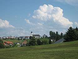
Sulzberg, Austria
| Sulzberg | ||
|---|---|---|
 | ||
| ||
 Sulzberg Location within Austria
Location in the district
| ||
| Coordinates: 47°31′00″N 09°54′00″E / 47.51667°N 9.90000°ECoordinates: 47°31′00″N 09°54′00″E / 47.51667°N 9.90000°E | ||
| Country | Austria | |
| State | Vorarlberg | |
| District | Bregenz | |
| Government | ||
| • Mayor | Helmut Blank (ÖVP) | |
| Area | ||
| • Total | 23.06 km2 (8.90 sq mi) | |
| Elevation | 1,015 m (3,330 ft) | |
| Population (1 January 2016)[1] | ||
| • Total | 1,773 | |
| • Density | 77/km2 (200/sq mi) | |
| Time zone | UTC+1 (CET) | |
| • Summer (DST) | UTC+2 (CEST) | |
| Postal code | 6934 | |
| Area code | 05516 | |
| Vehicle registration | B | |
| Website | www.sulzberg.at | |


Sulzberg is a municipality in the district of Bregenz in the Austrian state of Vorarlberg.
It is a member of the German-Austrian community project Naturpark Nagelfluhkette.
Toponymy
The place name "Sulzeberg" was first mentioned in documents in 1249. Around 1400, "Smaltzhuben uff the Sultzberg" were mentioned as inhabitants had to deliver lard and cheese to the Count of Bregenz.
Culture
- The parish church hl. Laurentius was extended from 1828 to 1829 according to the plans of Alois Negrelli of Moldelbe with the use of older parts in state empire style. In the years 1988 to 1991, the church was renovated with the Dean Herbert Hehle.
- Chapel St. Leonhard: Of the altogether 13 chapels of Sulzberg, the chapel St. Leonhard from the year 1497 is worth mentioning. It is not far from today's Sulzberg parish church on the road to Doren. The church originally belonged to the monastery Kempten (Allgäu). During the Thirty Years' War in 1647, the Swedes used the chapel as a stable for horses. The unique frescoes of the chapel and the altars and wooden ceilings from the early Baroque period have been preserved. The chapel has long been a popular place of pilgrimage. From 1980 to 2006, the chapel was unusable. Since November 2006, the chapel St. Leonhard shines in new splendor.
- Parish church Sulzberg-Thal.
- Marienlinde: The more than 400 years old lime tree. In its trunk, the trees houses a statue of Mary, with the inscription: „Maria vom Sieg, beende den Krieg und schütze uns mit deinem Kinde aus der Marienlinde.“ (Mary of victory, end the war and protect us with your child from the Marienlinde.)
Coat of arms
The coat of arms of the municipality Sulzberg shows a black, forward turned ox head over a green three-peaked mountain. The awarding of the coat of arms by the Vorarlberg state government took place on 1 February 1929. Presumably, the coat of arms designed by church archivist Andreas Ulmer is due to the agricultural expansion of the Sulzberg.
Population
| Historical population | ||
|---|---|---|
| Year | Pop. | ±% |
| 1869 | 1,489 | — |
| 1880 | 1,423 | −4.4% |
| 1890 | 1,439 | +1.1% |
| 1900 | 1,425 | −1.0% |
| 1910 | 1,443 | +1.3% |
| 1923 | 1,401 | −2.9% |
| 1934 | 1,487 | +6.1% |
| 1939 | 1,344 | −9.6% |
| 1951 | 1,579 | +17.5% |
| 1961 | 1,474 | −6.6% |
| 1971 | 1,574 | +6.8% |
| 1981 | 1,507 | −4.3% |
| 1991 | 1,577 | +4.6% |
| 2001 | 1,722 | +9.2% |
| 2011 | 1,750 | +1.6% |
References

Lime tree "Marienlinde"
| Wikimedia Commons has media related to Sulzberg (Vorarlberg). |

Hl. Laurentius
This article is issued from
Wikipedia.
The text is licensed under Creative Commons - Attribution - Sharealike.
Additional terms may apply for the media files.