Lochau
| Lochau | ||
|---|---|---|
 | ||
| ||
 Lochau Location within Austria
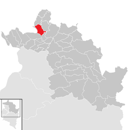
Location in the district
| ||
| Coordinates: 47°31′00″N 09°45′00″E / 47.51667°N 9.75000°ECoordinates: 47°31′00″N 09°45′00″E / 47.51667°N 9.75000°E | ||
| Country | Austria | |
| State | Vorarlberg | |
| District | Bregenz | |
| Government | ||
| • Mayor | Michael Simma | |
| Area | ||
| • Total | 10.27 km2 (3.97 sq mi) | |
| Elevation | 416 m (1,365 ft) | |
| Population (1 January 2016)[1] | ||
| • Total | 5,717 | |
| • Density | 560/km2 (1,400/sq mi) | |
| Time zone | UTC+1 (CET) | |
| • Summer (DST) | UTC+2 (CEST) | |
| Postal code | 6911 | |
| Area code | 05574 | |
| Vehicle registration | B | |
| Website | www.lochau.at | |

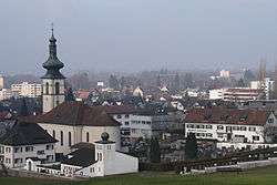
Lochau is a municipality in the Austrian state of Vorarlberg. It is located on Lake Constance, in the Bregenz district near the border to Germany.
About 50.3% of the municipality's area is forest. The Pfänder mountain is part of the municipality, also being the main mountain above Bregenz. In the west, the Leiblach river forms the border to the German rural district (Landkreis) of Lindau.
History
The Habsburgs reigned over their Vorarlberg lands alternately from Tyrol and Further Austria. From 1805 to 1814 the municipality belonged to Bavaria, then again to Austria. In 1861 it became part of the Austrian Federal State of Vorarlberg. During World War II, a subcamp of Dachau concentration camp was located here.[2] Between 1945 and 1955 the municipality was part of the French occupation zone.
Population
| Historical population | ||
|---|---|---|
| Year | Pop. | ±% |
| 1869 | 972 | — |
| 1880 | 925 | −4.8% |
| 1890 | 1,259 | +36.1% |
| 1900 | 1,362 | +8.2% |
| 1910 | 1,526 | +12.0% |
| 1923 | 1,455 | −4.7% |
| 1934 | 1,727 | +18.7% |
| 1939 | 1,717 | −0.6% |
| 1951 | 3,030 | +76.5% |
| 1961 | 3,745 | +23.6% |
| 1971 | 4,638 | +23.8% |
| 1981 | 5,239 | +13.0% |
| 1991 | 5,472 | +4.4% |
| 2001 | 5,242 | −4.2% |
| 2011 | 5,434 | +3.7% |
References
- ↑ Statistik Austria - Bevölkerung zu Jahresbeginn 2002-2016 nach Gemeinden (Gebietsstand 1.1.2016) for Lochau.
- ↑ "Archived copy". Archived from the original on 2009-02-09. Retrieved 2008-11-01.
External links
- (in German) Town of Lochau
| Wikimedia Commons has media related to Lochau. |
| Authority control |
|---|