Nagelfluhkette
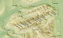
The Nagelfluhkette is a mountain range which is located in Bavaria, Germany and Vorarlberg, Austria. It reaches a maximum of 1834 m above sea level and borders the northern edge of the Allgäu Alps.[1] Its name derives from the rock type Nagelfluh. In older and geological literature, as well as in local vernacular language, one finds also the term Hochgratkette.
The geotope Nagelfluhkette is the most extensive object (and eponymous) of the Nagelfluhkette Nature Park, which was established on 1 January 2008.[2]
Location
The Nagelfluhkette extends in the western part of the Allgäu Alps west of the Illertal, in which the Bavarian cities Sonthofen and Immenstadt lie. In between these cities, Blaichach is located: From there, the mountain range stretches for about 20 km in west-southwest direction to Vorarlberg's Hittisau. The German-Austrian border runs on the saddle between Hohenfluhalpkopf and Hochhäderich (Hoher Häderich) over the mountain ridge.[3]
The Nagelfluhkette is one of the last higher elevations of the Alps, before further north adjoins the Alpine foothills of the Allgäu. In the north lies the valley of the west-flowing Weißach, in the southeast, the Hörnergruppe rises beyond the valley of the northeast flowing Aubach. To the east, the B 19 leads in the section "Sonthofen-Blaichach-Immenstadt".
Nagelfluhkette Nature Park
The Nagelfluhkette Nature Park is the first cross-border nature park between Germany and Austria and thus represents an international pilot project. It was established on 1 January 2008.
Priority objectives are protection, care and development of nature and landscape. It constitutes the first natural park in Bavaria in the Alps: The nature park is a relatively weak protection instrument, which primarily serves the connection of nature conservation and local tourism, and is primarily in the Bavarian Forest in use, not in the well-developed alpine area. In Vorarlberg – unlike in the other federal states of Austria – a nature park is not a legal protected area category. The Nagefluhkette Nature Park is a voluntary commitment of the nature park communities themselves. Therefore, the park is (as of 5/2011) not a member of the Association of Nature Parks of Austria (VNÖ).[4]
Size and participating communities
The Nagelfluhkette Nature Park covers 24,700 hectares in the district of Oberallgäu and 16,300 hectares in the adjacent Bregenzerwald, so a total of about 410 square kilometers. Six Oberallgäu communities and eight Vorarlberg communities joined forces for this project[5]:
- Germany: Balderschwang, Blaichach, Bolsterlang, Fischen, Immenstadt, Oberstaufen, Obermaiselstein
- Austria: Doren, Hittisau, Krumbach, Langenegg, Lingenau, Riefensberg, Sibratsgfäll, Sulzberg
Administration
The nature park administration ("Naturpark Nagelfluhkette e.V.") is based in Bühl am Alpsee, a district of Immenstadt. On the Austrian side, the nature park is looked after in the municipal offices.
Tourism
The Nagelfluhkette is flanked by lower mountain ridges to the north and south and thus offers an excellent view in almost all directions. Mountain railways operated all year round are available at Mittagberg (Mittagbahn) and Hochgrat (Hochgratbahn), each with a mountain restaurant.
Hiking
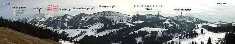
Due to the view, hikes on the Kammweg chain are of the most popular in the district of Oberallgäu. Since all mountains are individually mountable, there is a great variety of variations for a tightrope walk. Except for some treads, there are no complex climbing obstacles. Many places, especially between Steineberg and Stuiben, as well as between Falken and Hochhädrich, are exposed and require sure-footedness and a head for heights.[6]
Shorter routes lead, for example, from the mountain station of the Mittagbahn over the Steineberg and Stuiben through the Steigbachtal back to Immenstadt. Another way is the Maximiliansweg, which leads over the mountains Hochgrat, Rindalphorn and Buralpkopf in the range of the mountain range.
Established medium-length tours are the crossing of the entire eastern chain from Hochgrat to the Mittag (Nagelfluh-Gratwanderung), which follows the European long-distance trails E4 and E5 at this stage and the crossing of the western chain between Hochgrat and Falken (Luftiger Grat).[7]
The Königstour, the entire Nagelfluh crossing from Mittagberg to Hochhädrich is doable on a single day, provided the hiker is sportive and fit (about 8:30h including breaks). In any case, the Staufner Haus of the German Alpine Club is available as an accommodation hut.[8]
Winter sports
In addition to the mountain railways, there are ski lifts in addition to the Einguntkopf (from Falkenhütte) and Hochhädrich, each on the snow-sure north side.
Accordingly, slopes for skiers are located at Mittagberg, Hochgrat, Einguntkopf and Hochhädrich in Austria. Large parts of the Nagelfluh crossing are possible as winter hikes with snowshoes or touring skis.[9]
Mountains
The highest mountain of the Nagelfluhkette is the Hochgrat with a height of 1,834 m.[10]
| Name | Country | Height of vertex | Distinctive features |
|---|---|---|---|
| Mittagberg (Mittag) | Germany | 1,451 m | Double chair lift "Mittagbahn" |
| Bärenköpfle | Germany | 1,463 m | |
| Steineberg | Germany | 1,683 m | |
| Steinköpfle | Germany | 1,669 m | |
| Stuiben | Germany | 1,749 m | |
| Sedererstuiben | Germany | 1,737 m | |
| Buralpkopf | Germany | 1,772 m | |
| Gündleskopf | Germany | 1,748 m | |
| Rindalphorn | Germany | 1,822 m | |
| Gelchenwanger Kopf | Germany | 1,805 m | |
| Hochgrat | Germany | 1,834 m | Hochgratbahn, Staufner Haus |
| Seelekopf | Germany | 1,663 m | |
| Hohenfluhalpkopf | Germany/Austria | 1,636 m | |
| Eineguntkopf / Rohnehöhe | Germany/Austria | 1,641 m | |
| Falken(köpfe) | Germany/Austria | 1,564 m | Hut "Falkenhütte" (ca. 1450 m) |
| Hochhäderich (Hoher Häderich) | Germany/Austria | 1,565 m | Drag lift |
External links
References
- ↑ "Nagelfluhkette and Hörnergruppe : Climbing, Hiking & Mountaineering : SummitPost". www.summitpost.org. Retrieved 2018-09-07.
- ↑ Hartmann, Ralf. "Naturpark Nagelfluhkette - 8 Gemeinden aus dem vorderen Bregenzerwald und 6 Gemeinden aus dem westlichen Oberallgäu". www.dein-allgaeu.de. Retrieved 2018-08-28.
- ↑ "Naturpark Nagelfluhkette". ALPARC. Retrieved 7 September 2018.
- ↑ Hartmann, Ralf. "Naturpark Nagelfluhkette - 8 Gemeinden aus dem vorderen Bregenzerwald und 6 Gemeinden aus dem westlichen Oberallgäu". www.dein-allgaeu.de. Retrieved 2018-08-28.
- ↑ "Naturpark - Gemeinden - Naturpark Nagelfluhkette im Allgäu und Bregenzerwald". www.nagelfluhkette.info (in German). Retrieved 2018-08-28.
- ↑ "Stuiben und Steineberg". outdooractive (in German). Retrieved 2018-08-28.
- ↑ "Wandern: Nagelfluhkette Überquerung - 29km - Bergwelten". www.bergwelten.com (in German). Retrieved 2018-08-28.
- ↑ "Nagelfluhkette - Überschreitung". www.tourenziel.de (in German). Retrieved 2018-08-28.
- ↑ User, Super. "Infos - Mittagbahn Immenstadt, Doppelsessellift, Tiefschnee, Freeride, Rodeln, Wandern, Flugsport, Mountainbike, Alpen, Naturpark Nagelfluhkette". www.mittagbahn.de (in German). Retrieved 2018-08-28.
- ↑ "Nagelfluhkette and Hörnergruppe : Climbing, Hiking & Mountaineering : SummitPost". www.summitpost.org. Retrieved 2018-08-28.