Reuthe
| Reuthe | ||
|---|---|---|
 | ||
| ||
 Reuthe Location within Austria
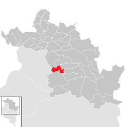
Location in the district
| ||
| Coordinates: 47°22′12″N 09°53′36″E / 47.37000°N 9.89333°ECoordinates: 47°22′12″N 09°53′36″E / 47.37000°N 9.89333°E | ||
| Country | Austria | |
| State | Vorarlberg | |
| District | Bregenz | |
| Government | ||
| • Mayor | Bianca Moosbrugger Petter | |
| Area | ||
| • Total | 10.24 km2 (3.95 sq mi) | |
| Elevation | 650 m (2,130 ft) | |
| Population (1 January 2016)[1] | ||
| • Total | 643 | |
| • Density | 63/km2 (160/sq mi) | |
| Time zone | UTC+1 (CET) | |
| • Summer (DST) | UTC+2 (CEST) | |
| Postal code | 6870 | |
| Area code | 05514 | |
| Vehicle registration | B | |
| Website | www.reuthe.at | |

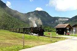
Reuthe is a municipality in the Austrian state of Vorarlberg in the district of Bregenz. Its main industry is tourism.
Population
| Historical population | ||
|---|---|---|
| Year | Pop. | ±% |
| 1869 | 315 | — |
| 1880 | 331 | +5.1% |
| 1890 | 257 | −22.4% |
| 1900 | 356 | +38.5% |
| 1910 | 357 | +0.3% |
| 1923 | 298 | −16.5% |
| 1934 | 349 | +17.1% |
| 1939 | 357 | +2.3% |
| 1951 | 418 | +17.1% |
| 1961 | 429 | +2.6% |
| 1971 | 534 | +24.5% |
| 1981 | 520 | −2.6% |
| 1991 | 578 | +11.2% |
| 2001 | 586 | +1.4% |
| 2011 | 611 | +4.3% |
Geography
Reuthe has an area of 10.24 km². It lies in the Bregenzerwald in the west of the country. 53.4% of the plain is forested, 11.6% is alpland. Reuthe is by surface and population one of the smallest municipalities in Vorarlberg.
Culture
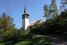
The parish church Hl. Jakobus was built in 1248. In 2002 a new organ was built.
Reuthe is part of the Bregenzerwald Umgang (literally "Bregenz forest walk"). The walk shows the design of 12 traditionally built villages in the Bregenz Forest. By means of the landscape, public buildings, houses and everyday objects, walkers are informed about the typical Bregenzerwälder architecture style throughout the centuries.
References
External links
| Wikimedia Commons has media related to Reuthe. |