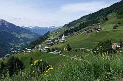
Fontanella, Austria
| Fontanella | ||
|---|---|---|
 | ||
| ||
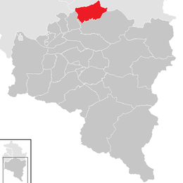
 Fontanella Location within Austria
Location in the district
| ||
| Coordinates: 47°14′51″N 09°54′33″E / 47.24750°N 9.90917°ECoordinates: 47°14′51″N 09°54′33″E / 47.24750°N 9.90917°E | ||
| Country | Austria | |
| State | Vorarlberg | |
| District | Bludenz | |
| Government | ||
| • Mayor | Werner Konzett (ÖVP) | |
| Area | ||
| • Total | 31.23 km2 (12.06 sq mi) | |
| Elevation | 1,145 m (3,757 ft) | |
| Population (1 January 2016)[1] | ||
| • Total | 447 | |
| • Density | 14/km2 (37/sq mi) | |
| Time zone | UTC+1 (CET) | |
| • Summer (DST) | UTC+2 (CEST) | |
| Postal code | 6733 | |
| Area code | 05554 | |
| Vehicle registration | BZ | |
| Website | www.fontanella.at | |

Fontanella is a municipality in the Austrian state of Vorarlberg.
Geography
About 29.5% of the municipality is forested, and 52.1% is alpine.
Subdivisions
The municipality consists of the villages Fontanella, Garlitt, Mittelberg, Türtsch, Kirchberg, Seewald and Faschina.
Economy
There are 18 companies. 102 persons are employed. In the tourism year 2001/2002 there were a total of 70,365 nights.
Population
| Historical population | ||
|---|---|---|
| Year | Pop. | ±% |
| 1869 | 456 | — |
| 1880 | 356 | −21.9% |
| 1890 | 344 | −3.4% |
| 1900 | 341 | −0.9% |
| 1910 | 352 | +3.2% |
| 1923 | 296 | −15.9% |
| 1934 | 354 | +19.6% |
| 1939 | 397 | +12.1% |
| 1951 | 370 | −6.8% |
| 1961 | 366 | −1.1% |
| 1971 | 402 | +9.8% |
| 1981 | 401 | −0.2% |
| 1991 | 422 | +5.2% |
| 2001 | 473 | +12.1% |
| 2011 | 434 | −8.2% |
History
Fontanella was founded by settlers from Valais in the 14th century. It was occupied by France from 1945 to 1955.
References
| Wikimedia Commons has media related to Fontanella. |
This article is issued from
Wikipedia.
The text is licensed under Creative Commons - Attribution - Sharealike.
Additional terms may apply for the media files.