2018–19 European windstorm season
| First storm formed | 16 September 2018 |
|---|---|
| Last storm dissipated | Season ongoing |
| Strongest storm1 | Callum (938 hPa) |
| Strongest wind gust |
Ex-Leslie (110 mph (180 km/h)) |
| Total storms | 5 |
| Total damage | Considerable (Northern Ireland and Scotland) |
| Total fatalities | 2 |
|
1Strongest storm is determined by lowest pressure and maximum recorded non-mountainous wind gust is also included for reference. ← 2017–18 2019–20 → | |
The 2018–19 European windstorm season is the fourth instance of seasonal European windstorm naming in Europe. Most storms form between September and March. The first named storm, Ali affected primarily Ireland, Northern Ireland and Scotland on the 19 September.[1]
Background and naming
In 2015, the Met Office and Met Éireann announced a pilot project to name storm warnings as part of the Name our Storms project for wind storms and asked the public for suggestions. The meteorological offices produced a full list of names for 2015–16 through to 2017–18, common to both the UK and Ireland. A new list of names was released on 11 September 2018 for the 2018–19 season.[2][3] Names in the UK will be based on the National Severe Weather Warning Service, when a storm is assessed to have the potential for an Amber 'be prepared' or Red 'take action (danger to life)' warning.
There are two main naming lists, created by the national meteorological agencies of the United Kingdom and Ireland, and France, Spain and Portugal respectively. Additionally, former Atlantic hurricanes will retain their names as assigned by the National Hurricane Center of the United States, as happened with Storm Ernesto and Storm Helene in September.
United Kingdom and Ireland
|
|
|
France, Spain and Portugal
This will be the second year in which the meteorological agencies of France, Spain and Portugal will be naming storms which affect their areas. This naming scheme is partially overlapping with that used by the UK and Ireland, as storms named by the other group of agencies will be used reciprocally.[4][5]
|
|
|
Additionally to these naming systems the Free University of Berlin also names high and low pressure areas through its "Adopt a vortex" programme. The Nordic nations of Denmark, Norway and Sweden also name storms with more limited reciprocation.[6] Other nations may also name storms either through their national meteorological institutions or popularly.
Season summary
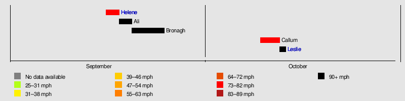
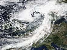
The season began on 16 September with the naming of Storm Helene, a former Atlantic hurricane, by the Met Office and Met Eireann; however, as it weakened considerably while approaching the British Isles, all warnings for Helene were discontinued on 18 September. Later that day, the second storm of the season, Storm Ali, was named by the Met Office and Met Eireann with the issuance of amber wind warnings for the following day. The third storm of the season, Bronagh, was named on 20 September; the earliest third named storm in a season since naming began.
Storms
The season was prefaced by the extra-tropical remnants of Hurricane Helene which affected the UK and Ireland on the 17–18 September. This began an active period of storm formation under a fast moving jet stream over the Atlantic.
Ex-Hurricane Helene
| Helene | |
|---|---|
 | |
| Area affected | Portugal, Spain, Ireland, United Kingdom |
| Date of impact | 16–18 September |
| Maximum wind gust | 78 mph (126 km/h), Cairngorms, Scotland[7] |
| Lowest pressure | 989 hPa (29.2 inHg) (while extratropical) |
| Fatalities | None |
| Power outages | None |
| Damage | Minimal |
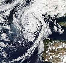
While still a tropical cyclone, Hurricane Helene affected the Azores from 15–16 September. The system subsequently completed an extratropical transition on 16 September as it accelerated north-eastwards towards the British Isles,[8] with the outer bands of Storm Helene causing minimal impacts in north-western Spain and Portugal.
Storm Helene crossed the UK and Ireland on 17–18 September, with the Met Office and Met Eireann issuing yellow wind warnings.[9] [10] The Met Office's yellow warning of wind covered southern England, the Midlands and Wales overnight from 17–18 September, with forecasts predicting winds of up to 60 to 70 mph (97 to 113 km/h).
Helene was downgraded as it approached the British Isles, with winds gusting to only 40 to 50 mph (64 to 80 km/h) in isolated locations; as a result, all warnings were cancelled on 18 September as Helene was still crossing the United Kingdom.

Storm Ali
| Ali | |
|---|---|
 | |
| Area affected | Ireland, Norway, United Kingdom |
| Date of impact | 18–20 September |
| Maximum wind gust | 102 mph (164 km/h) recorded at Tay Road Bridge, Scotland[11] |
| Lowest pressure | 967 hPa (28.6 inHg)[12] |
| Fatalities | 2 |
| Power outages | 286,000+ |
| Damage | Unknown |
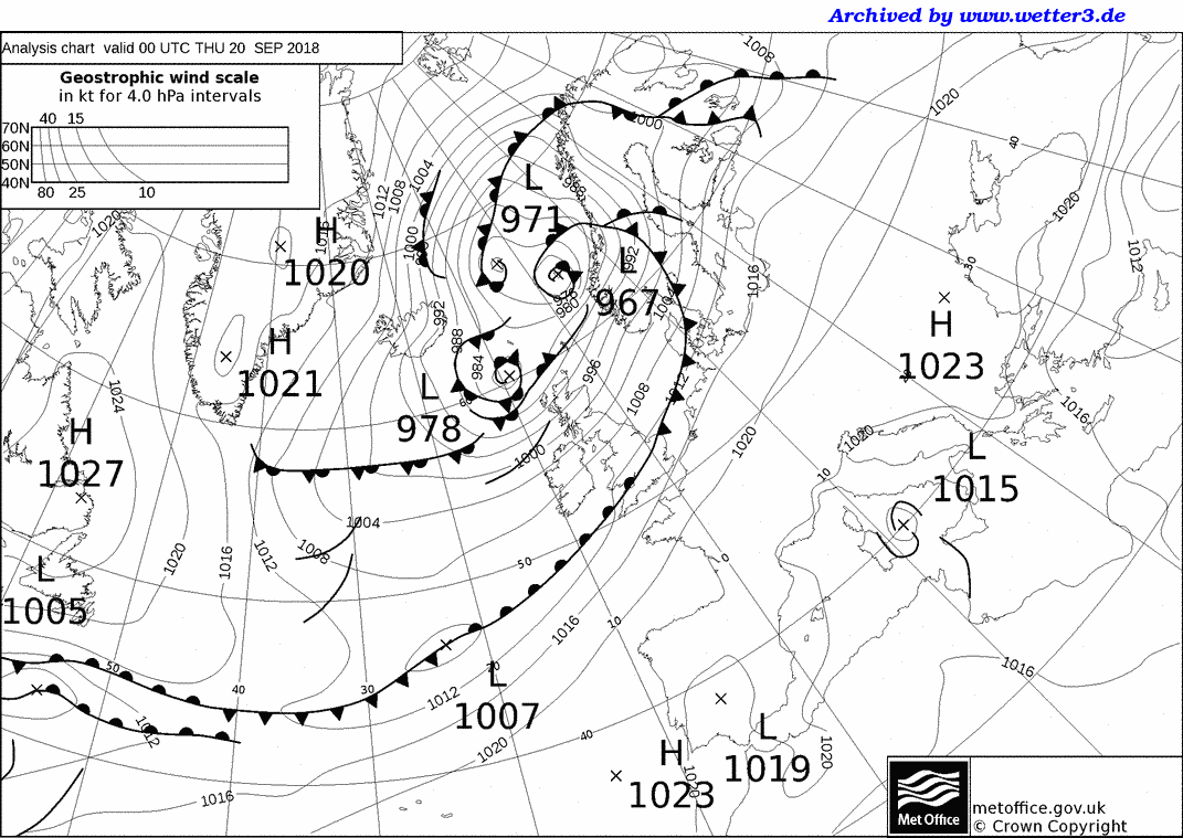
Storm Ali was named on 18 September by Met Éireann and Met Office, who both issued Amber weather warnings for wind associated with Ali. The centre of circulation of Ali made landfall in south-western Ireland in the early hours of 19 September, crossing into Northern Ireland before re-emerging into the Atlantic and then making a second landfall close to Ullapool in north-western Scotland at around 14:00. The highest wind gust recorded in the Republic of Ireland was 143 kilometres per hour (89 mph) at Mace Head weather station in County Galway.[13][14] The highest gust record in the United Kingdom was 102 miles per hour (164 km/h) recorded on the Tay Road Bridge in Scotland.[15] The winds on this storm were equivalent to a Category 2 on the Saffir-Simpson scale.
Storm Ali killed two people in Ireland and the United Kingdom. A caravan was blown over a cliff onto a beach near the village of Claddaghduff in County Galway, killing a woman who was visiting from Switzerland.[16] In County Armagh, a man in his 20s was killed by a falling tree.[17] Falling trees also severely injured a woman in Cheshire.[11] There was also severe tree damage in the Galway City and County region, which led to numerous school and road closures. Electricity supplies were lost to more than 100,000 homes across Northern Ireland, with more than 25,000 remaining without power into the following morning; the worst affected areas for power outages were Omagh, Dungannon and Enniskillen.[17] Across the border in the Republic of Ireland, more than 186,000 properties lost electricity during Ali, of which 119,000 had power restored by the end of the day.[17]
In County Antrim, the M1 motorway was closed in both directions for several hours after power cables fell across the carriageways.[18] Enterprise trains between Belfast and Dublin were delayed for up to seven hours due to debris on the tracks.[17] Services between Belfast and Derry were suspended, and a blanket speed restriction of 50 mph was enforced on all NI Railways services pending track inspections, causing widespread delays.[17] There were also delays to flights at Belfast International Airport.[17] In Greenock in Scotland, the MS Nautica cruise ship broke free from her moorings and drifted for several hours before being rescued by tugboats.[11]
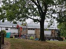
A major incident was declared by police in Dumfries and Galloway after many people were injured by flying debris; schools were placed on lockdown for the safety of students, as Ali's highest winds in this area occurred around the end of the school day.[11] On the Highland Main Line, a freight train was derailed after striking fallen tree branches.[11] In Cumbria, fallen trees and power lines caused disruption to transport and left homes without power; overturned lorries caused the M6 motorway to close for several hours, and Virgin Trains services along the West Coast Main Line were delayed or cancelled between Preston and Glasgow Central.[11] Dozens of trees fell or were damaged across the city of Sheffield, where council housing stock suffered considerable damage, including one housing block which had its roof ripped off in the Gleadless Valley area of the city.[19]
After clearing the UK, Ali made landfall in Norway, where several thousand homes were left without power in the west of the country.[20]
Storm Bronagh
| Bronagh | |
|---|---|
 | |
| Area affected | Ireland, Norway, United Kingdom, Denmark, Germany, Poland |
| Date of impact | 20–25 September |
| Maximum wind gust | 96 mph (154 km/h), Høllen, Norway |
| Lowest pressure | 969 hPa (28.6 inHg)[21] |
| Damage | Considerable flooding damage, particularly in the Sheffield area |
Bronagh first developed as a wave depression close to the southeast coast of Ireland.[22] The storm was named on 20 September, and was expected to develop further over the British Isles. Yellow weather warnings were issued with the "possibility" that further upgrades to Amber warnings may be needed depending on how Bronagh developed over the UK. However, Bronagh did not develop over the Isles, and instead strengthened over the North Sea. Thus, no Amber alert for Bronagh was issued by the UK Met Office.[23]
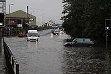
Bronagh brought heavy rainfall to southern Ireland, Wales, and northern England. Heavy rainfall fell across Wales and northern England on 20 September as Bronagh approached. In Sheffield, 66.2 millimetres (2.61 in) of rain fell in a 24 hour period, breaking the previous record of 58.9 millimetres (2.32 in) set on 14 September 1994 for the city's wettest September day since records began.[24] Rainfall accumulations reached 70 millimetres (2.8 in) widely across Wales and northern England, with some parts of Wales recording up to 100 millimetres (3.9 in) of rain.
As a result of heavy rainfall from Bronagh, widespread flooding was reported. Flash flooding in Sheffield was the worst to affect the city since June 2007. Along the A6178 Sheffield Road between Sheffield and Rotherham, rapidly rising floodwaters caused cars and vans to become stranded.[25] In nearby Tinsley, a woman had to be rescued from her car after becoming trapped in rising water.[26] East Midlands Trains reported that severe flooding from the River Sheaf and Porter Brook was affecting Sheffield station, with services delayed or cancelled as a result.[25] Bus services across the city were also suspended as the flooding peaked during the evening rush hour, stranding thousands of people. Flooding was additionally reported in Sheffield City Centre, Bradway, Intake, Meersbrook, Nether Edge and Woodseats amongst other districts.[27]
The storm continued to intensify over the North Sea, tracking toward Norway. The island of Heligoland and the Alte Weser lighthouse on the German coast recorded gusts of 107 km/h, while the Lindesnes Lighthouse in Norway recorded the highest wind speed at 154 km/h.[28] A truck driver in Hamburg suffered injuries after his truck was hit by a shipping container.[29]
Storm Callum
| Callum | |
|---|---|
 | |
| Area affected | Ireland, United Kingdom |
| Date of impact | 10–13 October |
| Maximum wind gust | 76 mph (122 km/h) |
| Lowest pressure | 938 hPa (27.7 inHg)[30] |
| Fatalities | 2 |
| Damage | Severe flooding in Wales as well as uprooting trees |
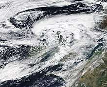
On 10 October, a tropical depression to the south of Spain organised into Storm Callum. Callum moved further northeastward while strengthening in particularly favourable conditions along with low wind shear. The system then underwent explosive cyclogenesis, as it was forced toward the United Kingdom by a jet stream.[31] On October 11, Callum began to show signs of an eye as it reached its' peak intensity on approach to Cardiff, Wales. Only then did it encounter colder waters and the low-level eye was exposed to westerly wind shear, which had an adverse effect on Callum before it made impact on land. The system then brought intense winds with speeds of up to 76 mph (122 km/h) to parts of northern England, along with torrential rains to parts of Wales with 95.6 mm (3.76 in) recorded in Libanus but overall only made a minimal impact on land.[32]Unexpected warm weather was reported soon after, with Donna Nook in Lincolnshire reaching 26.5 degrees Celsius in the afternoon.[33] At 21:00 UTC, colder water surface temperatures and high vertical wind shear affected Callum, and the system soon transitioned into an extratropical cyclone.
As of 13 October 2018, the storm has caused two indirect fatalities; a 33 year old man and a 35 year old woman are said to have encountered difficulties in the Penarth Marina. The storm has caused one direct fatality; a person died after a landslide in Cwmduad. [34]
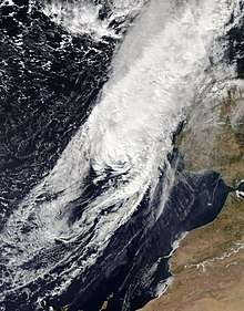
Ex-Hurricane Leslie
| Leslie | |
|---|---|
 | |
| Area affected | Portugal, Spain |
| Date of impact | 13 October–present |
| Maximum wind gust | 110 mph (180 km/h), Figueira da Foz, Portugal[35] |
| Lowest pressure | 984 hPa (29.1 inHg) (while extratropical) |
| Fatalities | None |
| Power outages | None |
| Damage | Unknown |
Hurricane Leslie was one of the longest-lived Atlantic hurricanes on record. A large, long-lived, and erratic tropical cyclone, Leslie was the twelfth named storm and sixth hurricane of the 2018 Atlantic hurricane season.
Season effects
| Storm | Dates active | Highest wind gust | Lowest pressure | Casualties | Damage | Affected areas |
|---|---|---|---|---|---|---|
| Helene | 16 – 18 September | 78 mph (126 km/h) | 989 hPa (29.21 inHg) | None | Minimal | Portugal, Spain, United Kingdom, Ireland |
| Ali | 18 – 20 September | 102 mph (164 km/h) | 967 hPa (28.56 inHg) | 2 | Unknown | Ireland, United Kingdom, Norway |
| Bronagh | 20 – 25 September | 78 mph (154 km/h) | 969 hPa (28.61 inHg) | None | Unknown | Ireland, United Kingdom, Norway, Denmark, Germany, Poland |
| Callum | 10 – 13 October | 86 mph (122 km/h) | 938 hPa (27.70 inHg) | 3 | Unknown | Ireland, United Kingdom, Wales |
| Leslie | 10 October – 13 October | 110 mph (180 km/h) | 984 hPa (29.06 inHg) | None | Unknown | Ireland, United Kingdom, Wales |
| 5 windstorms | 16 September – currently active | 110 mph (180 km/h) | 938 hPa (27.70 inHg) | 5 | Minimal |
Co-ordination of storms named by European meteorological services
| 2018–19 named storms table |
|---|
| Helene (NHC) 17 September 2018. |
| Ali (UK/IE), Dorcas (Free University of Berlin) 19 September 2018. |
| Bronagh (UK/IE), Elena (FUB),[36] Knud (Danish Meteorological Institute, also Norway and Sweden),[37][38] Mauri 18 (Finland).[39] 19–20 September 2018. |
| Fabienne (FUB) 23 September 2018. |
| Kuisma (Finland), Gertraud (FUB) 26 September 2018. |
| Callum (UK/IE), Nevine (FUB) 11–12 October 2018. |
| Leslie (NHC) 13–14 October 2018. |
References
- ↑ "High winds warning as Storm Ali hits". BBC News. 19 September 2018. Retrieved 20 September 2018.
- ↑ "Storm names for 2018–19 announced". Met Office. 11 September 2018. Retrieved 14 September 2018.
- ↑ "Storm Names 2018–19 Announced". www.met.ie. Met Éireann. 11 September 2018. Retrieved 14 September 2018.
- ↑ "Les listes des noms de tempêtes 2018–2019 rendues publiques" (in French). Météo France. 12 September 2018. Retrieved 14 September 2018.
- ↑ Meteorología, Agencia Estatal de (1 October 2018). "Nueva temporada de nombramiento de borrascas con gran impacto – Agencia Estatal de Meteorología – AEMET. Gobierno de España". www.aemet.es (in Spanish). Retrieved 3 October 2018.
- ↑ "Las listas de los nombres de borrascas para 2018–2019 – Revista del Aficionado a la Meteorología". Revista del Aficionado a la Meteorología (in Spanish). 13 September 2018. Retrieved 15 September 2018.
- ↑ weatheronline.co.uk. "Peak gusts, Table: UK/Europe : Current weather". www.weatheronline.co.uk. Retrieved 20 September 2018.
- ↑ Daniel Brown (September 16, 2018). "Post-Tropical Cyclone Helene Advisory Number 37". National Hurricane Center. Retrieved September 17, 2018.
- ↑ "Met Éireann briefing on Ex Tropical Storm Helene 4pm Monday 17th September – Met Éireann – The Irish Meteorological Service". www.met.ie. Met Éireann. 17 September 2018. Retrieved 17 September 2018.
- ↑ "Will Tropical Storm Helene affect the UK?". Met Office. 14 September 2018. Retrieved 14 September 2018.
- 1 2 3 4 5 6 "Two killed as Storm Ali brings 100mph winds". 19 September 2018. Retrieved 20 September 2018 – via www.bbc.co.uk.
- ↑ "18092000 UKMet Analysis". archived by www.wetter3.de. Met Office. 20 September 2018. Retrieved 20 September 2018.
- ↑ @MetEireann (18 September 2018). "Status Orange – Wind warning for Cavan, Monaghan, Donegal, Dublin, Kildare, Louth, Meath, Galway, Leitrim, Mayo, Sligo, Clare and Kerry" (Tweet) – via Twitter.
- ↑ "BBC Weather – UK Warnings". BBC Weather. 18 September 2018. Retrieved 18 September 2018.
- ↑ "Two killed as Storm Ali brings 100mph winds". BBC News. 19 September 2018. Retrieved 19 September 2018.
- ↑ "Woman dies as caravan is blown off cliff". BBC News. 19 September 2018. Retrieved 19 September 2018.
- 1 2 3 4 5 6 "Man killed by tree during Storm Ali". 19 September 2018. Retrieved 20 September 2018 – via www.bbc.co.uk.
- ↑ "M1 reopens after fallen cables cleared". 19 September 2018. Retrieved 20 September 2018 – via www.bbc.co.uk.
- ↑ "Storm Ali: Strong winds blow roof off house in Sheffield". Retrieved 20 September 2018.
- ↑ Løset, Oddleif (20 September 2018). "Kraftig vind har teke straumen frå fleire tusen". NRK (in Norwegian Nynorsk). Retrieved 20 September 2018.
- ↑ "Met Office analysis chart 12 UTC Friday 21 September 2018". archived at www.wetter3.de. Met Office. Retrieved 12 October 2018.
- ↑ "Update on Atlantic Storms near Ireland – Met Éireann – The Irish Meteorological Service". www.met.ie. 20 September 2018. Retrieved 20 September 2018.
- ↑ "Storm Bronagh". Met Office. 20 September 2018. Retrieved 20 September 2018.
- ↑ "Sheffield suffers wettest September day EVER, as nearly 7cm of rain falls in 24 hours". Retrieved 22 September 2018.
- 1 2 "Storm Bronagh brings travel problems". 21 September 2018. Retrieved 22 September 2018 – via www.bbc.co.uk.
- ↑ "Woman rescued from car stranded in flood". BBC News. Retrieved 22 September 2018.
- ↑ "Live updates as Storm Bronagh hits Sheffield – roads flooded and traffic chaos caused by heavy rain across region". Retrieved 22 September 2018.
- ↑ "Messwerte vom 21.09.2018, 16:00 Uhr – Deutschland". Retrieved 22 September 2018.
- ↑ Khan, Miriam. "Zahlreiche Schäden: Erster Herbststurm des Jahres fegt über Hamburg". Retrieved 22 September 2018.
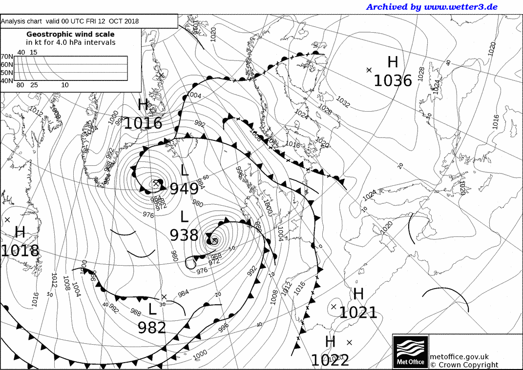
- ↑ http://www1.wetter3.de/Archiv/UKMet/18101200_UKMet_Analyse.gif
- ↑ https://www.express.co.uk/news/weather/1030441/uk-weather-forecast-storm-callum-met-office-weather-warning-october-2018
- ↑ https://www.telegraph.co.uk/news/2018/10/12/uk-weather-storm-callum-brings-rain-and76mph-winds-britain/
- ↑ https://twitter.com/metoffice/status/1051146628864851969
- ↑ https://news.sky.com/story/storm-callum-wales-hit-by-heaviest-flooding-for-20-years-11524923
- ↑ "Cyclone Leslie slams into Portugal, leaves 27 injured". Associated Press. 14 October 2018. Retrieved 14 October 2018.
- ↑ "Oberflächenanalyse Fr 21 September 2018 00 UTC". Free University of Berlin. 2018-09-21. Retrieved 2018-09-21.
- ↑ "Stormen hedder Knud: DMI". www.dmi.dk (in Danish). 20 September 2018. Retrieved 20 September 2018.
- ↑ "Ett potentiellt stormlågtryck på väg mot Sverige | SMHI". www.smhi.se (in Swedish). 20 September 2018. Retrieved 20 September 2018.
- ↑ "Gale winds at sea as autumn storm hits Finland". YLE. 22 September 2018. Retrieved 22 September 2018.