Wheatland County, Alberta
| Wheatland County | |
|---|---|
| Municipal district | |
 Welcome sign | |
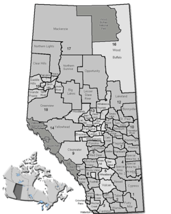 Location of Wheatland County in Alberta | |
| Coordinates: 51°02′16″N 113°24′01″W / 51.03778°N 113.40028°WCoordinates: 51°02′16″N 113°24′01″W / 51.03778°N 113.40028°W | |
| Country |
|
| Province |
|
| Region | Southern Alberta |
| Census division | No. 5 |
| Established | 1955 |
| Incorporated | 1961 (County) |
| Government[1] | |
| • Reeve | Glenn Koester |
| • Governing body |
Wheatland County Council
|
| • CAO | Alan Parkin |
| • Office location | east of Strathmore |
| Area (2016)[2] | |
| • Land | 4,545.92 km2 (1,755.19 sq mi) |
| Population (2016)[2] | |
| • Total | 8,788 |
| • Density | 1.9/km2 (5/sq mi) |
| Time zone | UTC-7 (MST) |
| Website | wheatlandcounty.ca |
Wheatland County is a municipal district in south-central Alberta, Canada, east of Calgary. Located in Census Division No. 5, its municipal office is located east of the Town of Strathmore on Highway 1.
Demographics
In the 2016 Census of Population conducted by Statistics Canada, Wheatland County recorded a population of 8,788 living in 2,836 of its 3,117 total private dwellings, a 6.1% change from its 2011 population of 8,285. With a land area of 4,545.92 km2 (1,755.19 sq mi), it had a population density of 1.9/km2 (5.0/sq mi) in 2016.[2]
In the 2011 Census, Wheatland County had a population of 8,285 living in 2,659 of its 2,941 total dwellings, a 2.2% change from its 2006 adjusted population of 8,109. With a land area of 4,539.26 km2 (1,752.62 sq mi), it had a population density of 1.8/km2 (4.7/sq mi) in 2011.[3]
Communities and localities
|
The following urban municipalities are surrounded by Wheatland County:[4]
The following hamlets are located within Wheatland County:[4]
|
The following localities are located within Wheatland County:[5]
|
See also
References
- ↑ "Municipal Officials Search". Alberta Municipal Affairs. September 22, 2017. Retrieved September 25, 2017.
- 1 2 3 "Population and dwelling counts, for Canada, provinces and territories, and census subdivisions (municipalities), 2016 and 2011 censuses – 100% data (Alberta)". Statistics Canada. February 8, 2017. Retrieved February 8, 2017.
- ↑ "Population and dwelling counts, for Canada, provinces and territories, and census subdivisions (municipalities), 2011 and 2006 censuses (Alberta)". Statistics Canada. February 8, 2012. Retrieved February 8, 2012.
- 1 2 "Specialized and Rural Municipalities and Their Communities" (PDF). Alberta Municipal Affairs. 2012-03-01. Retrieved 2012-08-12.
- ↑ "Standard Geographical Classification (SGC) 2006, Economic Regions: 4805012 - Wheatland County, geographical codes and localities, 2006". Statistics Canada. 2010-03-05. Retrieved 2012-08-12.
External links
Places adjacent to Wheatland County, Alberta | |
|---|---|