St. Charles Historic District
|
St. Charles Historic District | |
 | |
  | |
| Location | Roughly bounded by the Missouri River and Madison, Chauncey, and 2nd Sts.; also 1000 S. Main St.; also bounded by Madison, 2nd, Jefferson, and the alley behind the 100 block of S. Main St.; also the 100, 200, and 300 blocks of N. Main St., St. Charles, Missouri |
|---|---|
| Coordinates | 38°46′33″N 90°28′41″W / 38.77583°N 90.47806°WCoordinates: 38°46′33″N 90°28′41″W / 38.77583°N 90.47806°W |
| Area | 47 acres (19 ha), 1.3 acres (0.53 ha), 3.1 acres (1.3 ha), 9 acres (3.6 ha) |
| Architect | Multiple |
| Architectural style | Late 19th and 20th Century Revivals, Greek Revival, Late Victorian, Italianate |
| NRHP reference # |
70000856 (original) 87000903 (increase 1) 91000504 96001087[1] (increase 2) |
| Significant dates | |
| Added to NRHP | September 22, 1970 |
| Boundary increases |
June 4, 1987 May 1, 1991 October 10, 1996 |
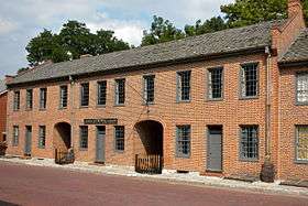
The St. Charles Historic District is a national historic district located at St. Charles, St. Charles County, Missouri. It is the site of the first permanent European settlement on the Missouri River and of the embarkation of Lewis and Clark's journey of exploration along the Missouri. The first state capital of Missouri and over one hundred other historic buildings are located in the district.[2]
The district was listed on the National Register of Historic Places in 1970, including 63 contributing buildings over a 47-acre (19 ha) area. The district was later increased three times.[1]
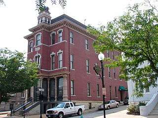
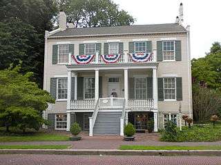
The original listing included the separately NRHP-listed First Missouri State Capitol Buildings and the Newbill-McElhiney House.[1][3] In 1987 the district was increased to include a Greek Revival specialty store building at 1000 S. Main Street, with a 1.3-acre (0.53 ha) area.[1] In 1991 the district was increased by 3.1 acres (1.3 ha) to include 13 more contributing buildings, including work by architects William D. Parsons and H.C. Bode. This included the St. Charles Odd Fellows Hall, the Old City Hall, a post office, and other buildings in Late 19th and 20th Century Revivals, Greek Revival, and Late Victorian architectural styles.[1][4]
In 1996 the district was further increased by 9 acres (3.6 ha) to include 41 more contributing buildings on the 100, 200, and 300 blocks of N. Main Street. These include Greek Revival, Italianate, and Late 19th and 20th Century Revivals architecture, including work by architects Albert B. Groves and Frank & Adolph Haverkamp.[1][5]
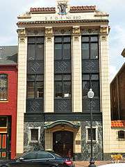 Elks building in the district
 | |
|
|
References
- 1 2 3 4 5 6 National Park Service (2009-03-13). "National Register Information System". National Register of Historic Places. National Park Service.
- ↑ "St. Charles Historic District". Lewis and Clark Expedition. National Park Service. Retrieved February 2, 2014.
- ↑ M. Patricia Holmes (May 1970). "National Register of Historic Places Inventory Nomination Form: St. Charles Historic District" (PDF). Missouri Department of Natural Resources. Retrieved 2017-02-01. (includes 12 photographs) and Site map
- ↑ Mary M. Stiritz (December 1990). "National Register of Historic Places Inventory Nomination Form: St. Charles Historic District (Boundary Increase #2)" (PDF). Missouri Department of Natural Resources. Retrieved 2017-02-01. (includes 7 photographs) and Site map
- ↑ Mary M. Stiritz (June 1996). "National Register of Historic Places Inventory Nomination Form: St. Charles Historic District (Boundary Increase III)" (PDF). Missouri Department of Natural Resources. Retrieved 2017-02-01. (includes 2 photographs) and Site map
External links
- Historic Main Street, City of St. Charles, Missouri.

