Sreemangal Upazila
| Srimangal শ্রীমঙ্গল | |
|---|---|
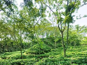 Tea gardens of Srimangal | |
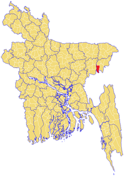 | |
| Division | Sylhet Division |
| District | Maulvibazar District |
| Government | |
| • MP (Maulvibazar-4) | Md Abdus Shahid (Awami League) |
| Area | |
| • Total | 450.74 km2 (174.03 sq mi) |
| Population | |
| • Total | 230,889 |
| • Density | 512/km2 (1,330/sq mi) |
| Time zone | UTC+6 (BST) |
| Postal code | 3210-14 |
Srimangal (Bengali: শ্রীমঙ্গল, Sylheti: ꠍ꠆ꠞꠤꠝꠋꠉꠟ) is an Upazila of Maulvibazar District[1] in the Sylhet Division of Bangladesh.
Geography
Sreemangal is located at 24°18′30″N 91°44′00″E / 24.3083°N 91.7333°E. It has 43,952 households and total area 450.74 km².
Climate
| Climate data for Sreemangal | |||||||||||||
|---|---|---|---|---|---|---|---|---|---|---|---|---|---|
| Month | Jan | Feb | Mar | Apr | May | Jun | Jul | Aug | Sep | Oct | Nov | Dec | Year |
| Average high °C (°F) | 25.9 (78.6) |
27.9 (82.2) |
32.0 (89.6) |
33.3 (91.9) |
32.6 (90.7) |
31.9 (89.4) |
31.8 (89.2) |
31.8 (89.2) |
32.0 (89.6) |
30.9 (87.6) |
29.1 (84.4) |
26.6 (79.9) |
30.5 (86.9) |
| Average low °C (°F) | 8.9 (48) |
11.4 (52.5) |
16.9 (62.4) |
21.1 (70) |
23.2 (73.8) |
24.5 (76.1) |
24.9 (76.8) |
24.8 (76.6) |
24.5 (76.1) |
21.8 (71.2) |
15.8 (60.4) |
10.7 (51.3) |
19 (66.3) |
| Average precipitation mm (inches) | 12 (0.47) |
28 (1.1) |
93 (3.66) |
219 (8.62) |
366 (14.41) |
498 (19.61) |
380 (14.96) |
331 (13.03) |
260 (10.24) |
192 (7.56) |
35 (1.38) |
6 (0.24) |
2,420 (95.28) |
| Source: Climate-data.org | |||||||||||||
Demographics
As of the 1991 Bangladesh census, Srimangal has a population of 230,889. Males constitute 51.76% of the total population, and females 48.24%. This Upazila's 18+ population is 124,778. Srimangal has an average literacy rate of 29.8% (7+ years), and the national average of 32.4% literate. Hindus constitute around 45% of the total population making up over one lakh, making it a city with one of the highest concentration of Hindus in Bangladesh.[2]
Administration
Srimangal has 9 Unions, 129 Mauzas/Mahallas, and 206 villages.
Education
According to Banglapedia, Victoria High School, founded in 1924, is a notable secondary school.[1]
See also
References
- 1 2 Gopal Dev Chowdhury (2012), "Sreemangal Upazila", in Sirajul Islam and Ahmed A. Jamal, Banglapedia: National Encyclopedia of Bangladesh (Second ed.), Asiatic Society of Bangladesh
- ↑ "Population Census Wing, BBS". Archived from the original on 2005-03-27. Retrieved November 10, 2006.
| Upazila/Thana: | ||
|---|---|---|
Capital: Sylhet | ||
| Habiganj District | 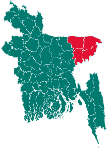 | |
| Moulvibazar District | ||
| Sunamganj District | ||
| Sylhet District | ||
| Authority control |
|---|