Spreetal
| Spreetal/Sprjewiny Doł | ||
|---|---|---|
| ||
 Spreetal/Sprjewiny Doł Location of Spreetal/Sprjewiny Doł within Bautzen district 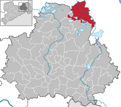  | ||
| Coordinates: 51°31′N 14°22′E / 51.517°N 14.367°ECoordinates: 51°31′N 14°22′E / 51.517°N 14.367°E | ||
| Country | Germany | |
| State | Saxony | |
| District | Bautzen | |
| Government | ||
| • Mayor | Manfred Heine | |
| Area | ||
| • Total | 108.73 km2 (41.98 sq mi) | |
| Elevation | 158 m (518 ft) | |
| Population (2017-12-31)[1] | ||
| • Total | 1,872 | |
| • Density | 17/km2 (45/sq mi) | |
| Time zone | CET/CEST (UTC+1/+2) | |
| Postal codes | 02979 | |
| Dialling codes | 035727 | |
| Vehicle registration | BZ | |
| Website | www.spreetal.de | |

Spreetal (Sorbian: Sprjewiny Doł) is a municipality in the district of Bautzen, in Saxony, Germany.
The municipality is part of the recognized Sorbian settlement area in Saxony. Upper Sorbian has an official status next to German, all villages bear names in both languages.
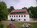 Municipal administration of Spreetal
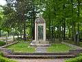 War memorial in Burgneudorf, district of Spreetal
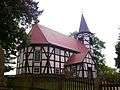 Church in Spreewitz, district of Spreetal
 Church in Burghammer, district of Spreetal
.JPG) Street in Burg, district of Spreetal
Street in Burg, district of Spreetal
References
- ↑ "Aktuelle Einwohnerzahlen nach Gemeinden 2017] (Einwohnerzahlen auf Grundlage des Zensus 2011)" (PDF). Statistisches Landesamt des Freistaates Sachsen (in German). October 2018.
This article is issued from
Wikipedia.
The text is licensed under Creative Commons - Attribution - Sharealike.
Additional terms may apply for the media files.