Elsterheide
| Elsterheide | ||
|---|---|---|
| ||
 Elsterheide Location of Elsterheide within Bautzen district 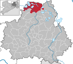  | ||
| Coordinates: 51°30′N 14°10′E / 51.500°N 14.167°ECoordinates: 51°30′N 14°10′E / 51.500°N 14.167°E | ||
| Country | Germany | |
| State | Saxony | |
| District | Bautzen | |
| Government | ||
| • Mayor | Dietmar Koark (CDU) | |
| Area | ||
| • Total | 126.85 km2 (48.98 sq mi) | |
| Elevation | 128 m (420 ft) | |
| Population (2017-12-31)[1] | ||
| • Total | 3,485 | |
| • Density | 27/km2 (71/sq mi) | |
| Time zone | CET/CEST (UTC+1/+2) | |
| Postal codes | 02979 | |
| Dialling codes | 03571 oder 03564 | |
| Vehicle registration | BZ | |
| Website | www.elsterheide.de | |

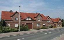
Nardt
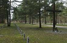
War graves in Nardt
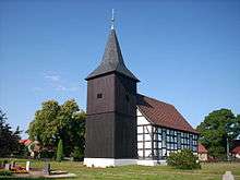
Church in Bluno
Elsterheide, in Sorbian Halštrowska hola, is a municipality in the district of Bautzen, in Saxony, Germany.
The municipality is part of the recognized Sorbian settlement area in Saxony. Upper Sorbian has an official status next to German.
History
The municipality of Elsterheide was formed in 1995 by merging the former municipalities of Neuwiese, Sabrodt, Nardt, Klein Partwitz, Seidewinkel, Tätzschwitz, Bluno and Geierswalde. Within Prussian Silesia (Province of Silesia 1815–1919 and 1938–41, Province of Lower Silesia 1919–38 and 1941–45), all of these municipalities were part of Landkreis Hoyerswerda. Within the East German Bezirk Cottbus, they were part of Kreis Hoyerswerda. With German unification in 1990, they became part of Saxony.
References
- ↑ "Aktuelle Einwohnerzahlen nach Gemeinden 2017] (Einwohnerzahlen auf Grundlage des Zensus 2011)" (PDF). Statistisches Landesamt des Freistaates Sachsen (in German). October 2018.
This article is issued from
Wikipedia.
The text is licensed under Creative Commons - Attribution - Sharealike.
Additional terms may apply for the media files.