Southeast Sulawesi
| Southeast Sulawesi Sulawesi Tenggara | |||
|---|---|---|---|
| Province | |||
 | |||
| |||
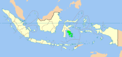
 Location of Southeast Sulawesi in Indonesia | |||
| Coordinates: 3°57′00″S 122°30′00″E / 3.95000°S 122.50000°ECoordinates: 3°57′00″S 122°30′00″E / 3.95000°S 122.50000°E | |||
| Country |
| ||
| Capital |
| ||
| Government | |||
| • Governor | Ali Mazi (Nasdem) | ||
| • Vice Governor | Vacant | ||
| Area | |||
| • Total | 38,140 km2 (14,730 sq mi) | ||
| Population (2014) | |||
| • Total | 2,417,962 | ||
| • Density | 63/km2 (160/sq mi) | ||
| Demographics | |||
| • Ethnic groups | Buton (23%), Bugis (19%), Tolaki (16%), Muna (15%) | ||
| • Religion | Islam (96.2%), Christian (2.3%), Hinduism (1.1%), Buddhism (0.4%) | ||
| • Languages |
Indonesian (official) Buginese (native) Cia-Cia (native) | ||
| Time zone | UTC+08 (Indonesia Central Time) | ||
| Vehicle registration | DT | ||
| HDI |
| ||
| HDI rank | 19th (2014) | ||
| Website | www.sultraprov.go.id | ||
Southeast Sulawesi (Indonesian: Sulawesi Tenggara, abbreviation: Sultra) is a province on the island of Sulawesi, forming the southeastern peninsula of that island, together with a number of large offshore islands such as Buton, Muna, Kabaena and Wawonii, with smaller islands. The capital is Kendari, on the east coast of the peninsula.
The province has no highway road connecting to the rest of the island, and the primary transportation link is a ferry across the Bone Gulf between Watampone (Bone) in South Sulawesi and the port of Kolaka in Southeast Sulawesi.
History
From the seventeenth century until the early twentieth century, the region was the site of the Buton sultanate (Butung).
Geography
The two major mountain ranges in Southeast Sulawesi are the Tanggeasinua Range and the Mekongga Range.[1] The major rivers are the Lalinda, the Lasolo, and the Sampara.[1][2]
Demographics
The unrevised population of the province was 1,771,951 in the Indonesia 2000 census, increasing to 2,230,569 for the 2010 decennial censuscomprising 1,120,225 males, and 1,110,344 females. Kolaka, Muna and Konawe Selatan were the 3 most populous regencies. The latest official estimate (for January 2014) is 2,417,962.Islam is predominant religion (96,2%).
Most of the population is centered on Buton and Muna islands off the south coast of Sulawesi, and in and around Kendari.
| Historical population | ||
|---|---|---|
| Year | Pop. | ±% |
| 1971 | 714,120 | — |
| 1980 | 942,302 | +32.0% |
| 1990 | 1,349,619 | +43.2% |
| 1995 | 1,586,917 | +17.6% |
| 2000 | 1,821,284 | +14.8% |
| 2010 | 2,232,586 | +22.6% |
| 2014 | 2,417,962 | +8.3% |
| Source: Badan Pusat Statistik 2010 & 2014 | ||
Religion
Ethnic groups
The main ethnic groups in Southeast Sulawesi are "Tolaki", "Buton", "Muna" etc.
Administrative divisions
Southeast Sulawesi is divided into twelve regencies (including the new East Kolaka Regency and Konawe Islands Regency, both established in 2013 from parts of Kolaka Regency and Konawe Regency respectively) and two autonomous cities, listed below with their (provisional) populations at the 2010 Census[4] and according to the latest official estimates (for January 2014),[5] although the latter do not take account of the new regencies created since 2010:
| Name | Area (km2) | Population Census 2010 | Population Estimate 2014 | Capital | HDI[6] 2014 estimate |
|---|---|---|---|---|---|
| Kendari | 301 | 289,468 | 314,042 | Kendari | 0.813 (Very High) |
| Bombana Regency 1 | 3,001 | 139,271 | 150,796 | Rumbia | 0.633 (Medium) |
| Kolaka Regency | 6,918 | 314,812 | 341,406 | Kolaka | 0.702 (High) |
| Konawe Regency | 5,303 | 241,428 | 262,074 | Unaaha | 0.686 (Medium) |
| North Kolaka Regency (Kolaka Utara) | 3,392 | 121,476 | 131,415 | Lasasua | 0.657 (Medium) |
| North Konawe Regency (Konawe Utara) | 5,102 | 51,447 | 55,812 | Wanggudu | 0.660 (Medium) |
| South Konawe Regency (Konawe Selatan) | 5,779 | 264,197 | 286,556 | Andoolo | 0.656 (Medium) |
| Peninsula Regencies | 29,796 | 1,422,099 | 1,542,101 | ||
| Bau-Bau | 220.99 | 137,118 | 148,366 | Bau-Bau | 0.731 (High) |
| Buton Regency | 2,681.22 | 255,474 | 276,944 | Bau-Bau | 0.623 (Medium) |
| Muna Regency | 2,945.05 | 268,140 | 290,553 | Raha | 0.650 (Medium) |
| North Buton Regency (Buton Utara) | 1,864.91 | 54,816 | 59,281 | Burangga | 0.646 (Medium) |
| Wakatobi Regency | 559.54 | 92,922 | 100,717 | Wanci, on Wangi-wangi Island | 0.669 (Medium) |
| Island Regencies | 8,271.71 | 808,470 | 875,861 |
Notes:
The figures for the Konawe Regency include those for the newly established Konawe Islands Regency (which is wholly insular, essentially consisting of the island of Wawonii), and the figures for the Kolaka Regency include those for the newly established East Kolaka Regency.
1 – Bombana Regency is partly peninsula (the areas around Poleang and Rumbia) and partly insular (including all of Kabaena Island).
In 2012-13 the Indonesian Government enacted the creation of 11 new Regencies and Municipalities, including the following in Southeast Sulawesi:
On 24 June 2014, the Indonesian Parliament agreed to create three new regencies: West Muna Regency, South Buton Regency and Central Buton Regency based on consideration of technical, administrative, area, strategic and geopolitic factors.[7]
Under discussion is a proposal to create an additional municipality of Raha. These five new regencies created since 2010, and the potential extra municipality, are not separated in the table above.
See also
References
- 1 2 "Tanggeasinua Mountains". Encyclopædia Britannica. Archived from the original on 2 March 2015.
- ↑ TPC M-12 AG, Indonesia (Map) (first ed.). 1:500,000. Director of Military Survey, Ministry of Defence, United Kingdom. 1972.
- ↑ "Population by Region and Religion in Indonesia". BPS. 2010.
- ↑ Biro Pusat Statistik, Jakarta, 2011.
- ↑ Penduduk Menurut Umur Tunggal - Tahun 2014
- ↑ Indeks-Pembangunan-Manusia-2014
- ↑ Riza Harahap (June 24, 2014). "DPR setujui tiga kabupaten baru di Sultra".


