South Banat District
| South Banat District Južnobanatski okrug Јужнобанатски округ | |
|---|---|
| District of Serbia | |
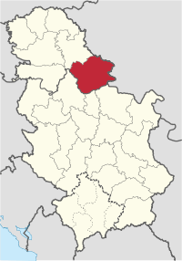 Location of the South Banat District within Serbia | |
| Country |
|
| Province | Vojvodina |
| Administrative center | Pančevo |
| Government | |
| • Commissioner | Danijela Lončar |
| Area | |
| • Total | 4,245 km2 (1,639 sq mi) |
| Population (2011 census) | |
| • Total | 291,327 |
| • Density | 69/km2 (180/sq mi) |
| ISO 3166 code | RS-04 |
| Municipalities | 8 (2 cities) |
| Settlements | 94 |
| - Cities and towns | 10 |
| - Villages | 84 |
| Website |
juznobanatski |

The South Banat District (Serbian: Јужнобанатски округ / Južnobanatski okrug, pronounced [jûʒnobǎnaːtskiː ôkruːɡ]) is one of seven administrative districts of the autonomous province of Vojvodina, Serbia. The administrative center of the district is the city of Pančevo. The district lies in the region of Banat. According to the 2011 census results, it has a population of 291,327 inhabitants.
Name
In Serbian, the district is known as Južnobanatski okrug (Јужнобанатски округ), in Croatian as Južnobanatski okrug, in Hungarian as Dél-bánsági körzet, in Slovak as Juhobanátsky okres, in Romanian as Districtul Banatul de Sud, and in Rusyn as /Јужнобанатски окрух/.
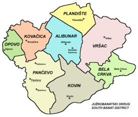
Municipalities
It encompasses the cities of Pančevo and Vršac and the following municipalities:
Demographics
| Historical population | ||
|---|---|---|
| Year | Pop. | ±% p.a. |
| 1948 | 279,092 | — |
| 1953 | 291,125 | +0.85% |
| 1961 | 320,187 | +1.20% |
| 1971 | 331,285 | +0.34% |
| 1981 | 340,189 | +0.27% |
| 1991 | 328,428 | −0.35% |
| 2002 | 313,937 | −0.41% |
| 2011 | 293,730 | −0.74% |
| Source: [1] | ||
According to the last official census done in 2011, the South Banat District has 293,730 inhabitants.
Ethnic groups
Most of the municipalities in the district have an ethnic Serb majority, while the municipality of Kovačica is ethnically mixed, with a relative Slovak majority (41.8%). Ethnic composition of the South Banat district:[2]
| Ethnic group | Population |
|---|---|
| Serbs | 208,462 |
| Romanians | 18,000 |
| Slovaks | 13,777 |
| Hungarians | 13,194 |
| Romani | 8,025 |
| Macedonians | 6,548 |
| Croats | 1,512 |
| Yugoslavs | 1,178 |
| Montenegrins | 921 |
| Bulgarians | 757 |
| Muslims | 586 |
| Germans | 472 |
| Slovenes | 358 |
| Albanians | 250 |
| Russians | 184 |
| Bosniaks | 144 |
| Vlachs | 123 |
| Others | 19,239 |
| Total | 293,730 |
Culture
Pančevo is distinguished for its numerous cultural institutions: the National Library 'Veljko Vlahović', the Historic Archives, and the Institute for Protection of Culture Monuments.
The most remarkable cultural monuments in this region are the Vojlovica Monastery built in 1405, the Church of Assumption, the Church of Transfiguration built in 1811 and the National Museum built in 1833.
Economy
In this modern, industrial region stand out the Pančevo Oil Refinery, the Azotara Fertilizers Plants, and the Pančevo Petrochemistry.
See also
Places adjacent to South Banat District | ||||||||||
|---|---|---|---|---|---|---|---|---|---|---|
| ||||||||||
References
- ↑ "2011 Census of Population, Households and Dwellings in the Republic of Serbia" (PDF). stat.gov.rs. Statistical Office of the Republic of Serbia. Retrieved 16 January 2017.
- ↑ "Попис становништва, домаћинстава и станова 2011. у Републици Србији" (PDF). stat.gov.rs. Republički zavod za statistiku. Retrieved 16 January 2017.
Note: All official material made by Government of Serbia is public by law. Information was taken from official website.
External links
| Wikimedia Commons has media related to South Banat District. |
- juznobanatski.okrug.gov.rs (in Serbian)