Central Banat District
| Central Banat District Srednjobanatski okrug Средњобанатски округ | |
|---|---|
| District of Serbia | |
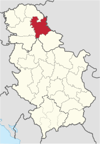 Location of the Central Banat District within Serbia | |
| Country |
|
| Province |
|
| Administrative center | Zrenjanin |
| Government | |
| • Commissioner | Dušan Šijan |
| Area | |
| • Total | 3,256 km2 (1,257 sq mi) |
| Population (2011 census) | |
| • Total | 187,667 |
| • Density | 58/km2 (150/sq mi) |
| ISO 3166 code | RS-02 |
| Municipalities | 4 and 1 city |
| Settlements | 55 |
| - Cities and towns | 4 |
| - Villages | 51 |
| Website |
www |
The Central Banat District (Serbian: Средњобанатски округ, Srednjobanatski okrug, pronounced [srêdɲoːbǎnaːtskiː ôkruːɡ]) is one of seven administrative districts of the autonomous province of Vojvodina, Serbia. It lies in the geographical region of Banat. According to the 2011 census results, it has a population of 186,851 inhabitants. The administrative center is the city of Zrenjanin.
Name
In Serbian, the district is known as Srednjobanatski okrug or Средњобанатски округ, in Croatian as Srednjobanatski okrug, in Hungarian as Közép-bánsági körzet, in Slovak as Sredobanátsky okres, in Romanian as Districtul Banatul Central, and in Rusyn as Стредобанатски окрух.
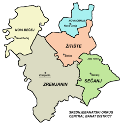
Municipalities
It encompasses the city of Zrenjanin and the following municipalities:
Demographics
| Historical population | ||
|---|---|---|
| Year | Pop. | ±% p.a. |
| 1948 | 218,821 | — |
| 1953 | 221,667 | +0.26% |
| 1961 | 229,812 | +0.45% |
| 1971 | 231,486 | +0.07% |
| 1981 | 230,962 | −0.02% |
| 1991 | 221,353 | −0.42% |
| 2002 | 208,456 | −0.54% |
| 2011 | 187,667 | −1.16% |
| Source: [1] | ||
According to the last official census done in 2011, the Central Banat District has 187,667 inhabitants.
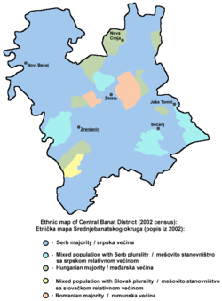
Ethnic groups
Ethnic composition of the Central Banat district:[2]
| Ethnic group | Population |
|---|---|
| Serbs | 134,264 |
| Hungarians | 23,550 |
| Romani | 7,267 |
| Romanians | 4,214 |
| Slovaks | 2,135 |
| Croats | 796 |
| Yugoslavs | 769 |
| Macedonians | 521 |
| Montenegrins | 378 |
| Bulgarians | 298 |
| Germans | 219 |
| Albanians | 194 |
| Muslims | 116 |
| Slovenes | 113 |
| Russians | 108 |
| Others | 12,725 |
| Total | 187,667 |
Churches
There are many buildings that stand out by their beauty: the Orthodox Church of Assumption from 1746, the Roman Catholic Church in Arač from 13th century and the Roman Catholic Cathedral from 1868 and the Reformatory Church from 1891.
Economy
Economy of Zrenjanin is diverse: industry, agriculture, forestry, building industry, and transport.
The leading branch is the food-processing industry, integrated under the "Servo Mihalj" Industrial - Agricultural Combine.
Other major representatives of the Zrenjanin economy are: the DD "ZIP" brewery, the DD "Luxol" chemical industry and sugar factory.
However, many companies are in very bad condition, except "Dijamant" oil industry and "Mlekoprodukt" milk factory.
The city of Zrenjanin used to be the fourth largest industry center in former Yugoslavia.
See also
Places adjacent to Central Banat District | ||||||||||
|---|---|---|---|---|---|---|---|---|---|---|
| ||||||||||
References
- ↑ "2011 Census of Population, Households and Dwellings in the Republic of Serbia" (PDF). stat.gov.rs. Statistical Office of the Republic of Serbia. Retrieved 16 January 2017.
- ↑ "Попис становништва, домаћинстава и станова 2011. у Републици Србији" (PDF). stat.gov.rs. Republički zavod za statistiku. Retrieved 16 January 2017.
Note: All official material made by Government of Serbia is public by law. Information was taken from official website.
External links
| Wikimedia Commons has media related to Central Banat District. |