Smithfield, New South Wales
| Smithfield Sydney, New South Wales | |||||||||||||||
|---|---|---|---|---|---|---|---|---|---|---|---|---|---|---|---|
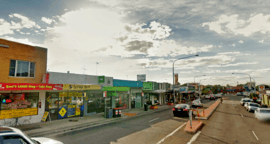 Smithfield town center | |||||||||||||||
|
Smithfield | |||||||||||||||
| Coordinates | 33°51′10″S 150°55′55″E / 33.85278°S 150.93194°ECoordinates: 33°51′10″S 150°55′55″E / 33.85278°S 150.93194°E | ||||||||||||||
| Population | 11,972 (2016 census)[1] | ||||||||||||||
| Established | 1836 | ||||||||||||||
| Postcode(s) | 2164 | ||||||||||||||
| LGA(s) | |||||||||||||||
| State electorate(s) | |||||||||||||||
| Federal Division(s) | McMahon | ||||||||||||||
| |||||||||||||||
| |||||||||||||||
Smithfield is a suburb of Sydney, in the state of New South Wales, Australia. Smithfield is located 30 kilometres (19 mi) west of the Sydney central business district, in the local government areas of the City of Fairfield and Cumberland Council. The suburb is in the Greater Western Sydney region. By area, it is one of the largest suburbs in Fairfield City.
Established in 1836, Smithfield was the first major settlement of the Fairfield LGA.[2] The original 1838 summary plan of Smithfield shows the suburb laid out in a grid pattern with most of the streets having the same names as they do today.[3] Its altitude ranges from 21 to 48 m (69 to 157 ft) above sea level. Geologically, the suburb sits on the Cumberland Plain. The suburb is a mix of residential, industrial and commercial areas, but is mostly characterized by low-density housing.[4]
History
Aboriginal people from the Cabrogal tribe, a sub-group of the Gandangara tribe, have lived in the Fairfield area for over 30,000 years.
White settlement began in the area in the early 19th century. Smithfield was originally known as Chilsholm's Bush. In 1803, homeless children were becoming a problem after convicts turned their children out into the streets. As a consequence, Governor Philip Gidley King, put aside a large area of 12,300 acres (50 km2) for a Male Orphan School. By 1836, some of this land was offered for sale by the colonial government of the time. John Ryan Brenan (1798–1868), an attorney who was appointed Police Magistrate in 1836, bought 1,650 acres (7 km2) here. Early settlers were attracted to Smithfield by its good soil, dependable water supply and easy access to the Colony's established towns. Some of the best farming land was in the district to the west and southwest of the Smithfield area. In 1867, Smithfield was a semi-rural settlement populated by vine growers, gardeners, wood timber cutters, orchards and tanneries.
Brenan planned to make money with a meat market and a cattle sale yard. He subdivided the estate and named it Smithfield after the meat markets of London and Dublin. Saleyards opened in 1841 but the project to establish a village around the yards failed. Despite this, Smithfield did become a thriving commercial centre and remains a significant employment centre in south-western Sydney as part of the Wetherill Park/Yennora industrial block.
Smithfield still has the street patterns Brenan planned and the street names he chose. In the subdivision, Brenan offered an extra adjoining allotment to any buyer who built a cottage with a brick chimney and enclosed the property with a fence. The public school opened in 1850 and by the 1880s Smithfield was well provided with churches, many of which still remain today as important relics of Smithfield's rich local heritage.[5]
Transport
The Horsley Drive is the major road which runs through Smithfield. Other major roads include Polding Street, Brennan Street and Victoria Street. Bus services are provided by Transit Systems Sydney. The closest train station is Fairfield train station, on the Airport, Inner West & South Line and Cumberland line. There are bus links to that station. There is a cycle way that runs through the suburb, which is part of the Western Sydney Regional Park recreational route.[6]
Commercial area
The commercial area is centred on The Horsley Drive, the main street in Smithfield. The shopping centre features a Coles supermarket, a gymnasium, specialty shops, multicultural restaurants (namely Middle Eastern and Chinese) and a prominent pub on The Horsley Drive and Cumberland Highway (Smithfield Tavern), which features a restaurant, a TAB, adult entertainment sessions and concert parties. There is a large industrial area in Smithfield with a number of factories and warehouses.
Culture
Smithfield features an art gallery, museum and an RSL club. Smithfield was the location for the SBS TV show Housos, being one of the many locations for that TV show.
Places of worship
- St James Anglican church is on the corner of The Horsley Drive and Justin Street
- St Benedicts Catholic Church is in Justin Street
- Smithfield Uniting Church is on The Horsley Drive
- St Mary's Church, an Assyrian church is in Polding Street
- Smithfield mosque, established by Bosnian immigrants in the early 1970s, is located in Bourke Street. It was named Gazi Husrev-beg Mosque in memory of a historical figure of Sarajevo in Bosnia and Herzegovina.[7]
Recreational areas
Brenan Park is a large recreational area, and one of the most prominent in Fairfield City, which features sports grounds, children's playgrounds and picnic areas.[8]
Rosford Street Reserve is a parkland in the northern skirts of the suburb which features a large sports grounds and an urban forest. It adjoins Long Street Park, which is situated in Cumberland Council section of Smithfield.
Education
There is are local primary schools. Smithfield Primary and Smithfield West Primary. There are no local high schools, however, residents living in the western vicinity of Smithfield are in the area for Westfields Sports High School, and Fairfield High School for those living in the southeastern outskirts of the suburb. There is a TAFE nearby in Wetherill Park.
Politics
Smithfield is governed at the local government level by Fairfield City Council, with Frank Carbone (Labor) as Mayor. At the state level, Andrew Rohan (Liberal) is the State MP for Smithfield. At the federal level, Chris Bowen and Jason Clare (both Labor) are Federal MPs for the seats of McMahon and Blaxland respectively.
Demographics
According to the 2016 Australian Bureau of Statistics Census of Population, there were 11,972 persons usually resident in Smithfield. The median age of people in Smithfield was 37 years. Children aged 0–14 years made up 19.9% of the population and people aged 65 years and over made up 16.5% of the population. Smithfield had an unemployment rate of 8.4%.[1]
- Ethnic diversity
The most common ancestries in Smithfield were Australian (11.4%), English (9.3%), Italian (7.8%), Vietnamese (7.1%) and Assyrian (7.0%). 39.6% of people only spoke English at home. Other languages spoken at home included Arabic (12.1%), Vietnamese (8.9%), Assyrian Neo-Aramaic (8.2%), Italian (5.9%) and Spanish (4.5%).[1]
- Country of birth
Of the people in Smithfield, 46.0%% of them were born in Australia. 16.7% of people had both parents born in Australia and 69.1%% of people had both parents born overseas. The other common countries of birth were Iraq (14.0%), Vietnam (6.0%), Italy (3.3%), Lebanon (2.1%) and Syria (1.7%).[1]
- Religion
Almost three in four residents (69.8%) practice Christianity. The most common responses for religion were Catholic (40.1%), No Religion (10.0%), Islam (8.2%), Buddhism (7.9%) and Not stated (7.9%).[1]
- Housing
Separate housing dominates the area, comprising 77.8% of total occupied private dwellings, 10.7% were semi-detached, row or terrace houses, townhouses etc., 8.7% were flat or apartments and 2.0% were other dwellings. 30.3% of the dwellings were owned and 27.2% were owned with a mortgage, and 38.0% were rented. 7.5% had 1 bedroom, 13.2% had 2 bedrooms and 47.2% had 3 bedrooms. The average number of bedrooms per occupied private dwelling was 3.1. 50.0%% were couple families with children, 24.9%% were couple families without children and 23.1%% were one parent families. 18.0% of single parents were male and 82.0% were female.[1]
Notable residents
Smithfield was the childhood home of socceroos footballer, Harry Kewell.[9][10] Shadow treasurer Chris Bowen grew up in this suburb and is currently a resident.[11]
Gallery
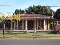 Smithfield museum
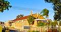 St Mary's Church, an Assyrian place of worship
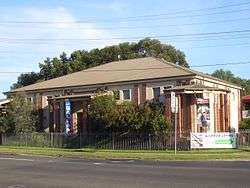 Smithfield gallery
 Smithfield Tavern
References
- 1 2 3 4 5 6 Australian Bureau of Statistics (27 June 2017). "Smithfield (State Suburb)". 2016 Census QuickStats. Retrieved 27 June 2017.

- ↑ Fairfield City Council (February 1999) Know your suburb – Smithfield Fairfield City Council
- ↑ George V (1991) Fairfield – A History of the District – second edition Fairfield City Council
- ↑ Fairfield City Council (1994) Local Environment Plan Fairfield City Council
- ↑ "Fairfield City Council". Fairfieldcity.nsw.gov.au. Retrieved 2015-02-27.
- ↑ "Fairfield LGA Smithfield : Map" (PDF). Fairfield.nsw.gov.au. Retrieved 2015-02-27.
- ↑ "30 Bourke St, Smithfield New South Wales 2164 - Google Maps". Maps.google.com.au. 1970-01-01. Retrieved 2015-02-27.
- ↑ King M & Associates (1997) Recreation Needs Assessment Study prepared for Fairfield City Council
- ↑ Archived 4 October 2011 at the Wayback Machine.
- ↑ Archived 6 August 2008 at the Wayback Machine.
- ↑ Federal Treasurer still values support from his parents as he battles to hold on to McMahon by Frances Sacco, The Daily Telegraph
| Wikimedia Commons has media related to Smithfield, New South Wales. |