Pemulwuy, New South Wales
| Pemulwuy Sydney, New South Wales | |||||||||||||||
|---|---|---|---|---|---|---|---|---|---|---|---|---|---|---|---|
 Pemulwuy Marketplace | |||||||||||||||
| Population | 5,009 (2016 census)[1] | ||||||||||||||
| Postcode(s) | 2145 | ||||||||||||||
| Location |
| ||||||||||||||
| LGA(s) | Cumberland Council | ||||||||||||||
| State electorate(s) | Prospect | ||||||||||||||
| |||||||||||||||
Pemulwuy is a suburb of Sydney, in the state of New South Wales, Australia. Pemulwuy is located 30 kilometres west of the Sydney central business district in the local government area of the Cumberland Council. Pemulwuy is home to the highest point between the Blue Mountains and Sydney, the summit of Prospect Hill.
Geography
The eastern portion consists in the most part of high density town-house like development, while the western area consists of very large warehouse and distribution facilities. The southern zone of the suburb is promoted by property developers Lend Lease Group as "Nelson's Ridge" named after Nelson Simmons Lawson, son of William Lawson, the owner of the Grey Stanes Estate. The northern zone of the suburb is promoted by Stockland as "Lakewood".[2]
History
Pemulwuy is named after the Aboriginal warrior, Pemulwuy, who led attacks on the British settlements in the surrounding areas, particularly on the Toongabbie settlement. Pemulwuy, formerly part of Prospect, is a relatively new suburb, with development beginning in 2004 on the site of a former Boral quarry and CSIRO sites.[2][3]
Street names in the suburb include Watkin Tench Parade, named after Captain Watkin Tench, who was the first European to record an ascent of Prospect Hill in 1789.[4]
Demographics
- The most common ancestries were Australian 15.0%, English 10.8%, Indian 10.3%, Filipino 8.3% and Chinese 6.2%.
- 48.9% of people only spoke English at home. Other languages spoken at home included Hindi 6.0%, Arabic 4.2%, Tagalog 3.8%, Gujarati 2.8% and Cantonese 2.7%.
- 52.4% of people were born in Australia. The most common countries of birth were India 7.2%, Philippines 6.7%, Fiji 3.6%, Sri Lanka 2.5% and England 1.5%.
- The most common responses for religion were Catholic 40.2%, Hinduism 11.8%, No Religion 9.7%, Anglican 7.3% and Islam 6.9%.[5]
Commercial area
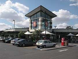
The Pemulwuy Marketplace is located on the intersection of Greystanes Road and Butu Wargun Drive along with a community centre and child care centre. Another shopping centre, called Nelsons Ridge Plaza, is located on Watkin Tench Parade.
Parks and reserves
The suburb is home to many parks and reserves such as:
- Grey Box Reserve
- Dirrabari Reserve (including dog park)
- Driftway Reserve
- Andrew Campbell Reserve
- Marrong Reserve or Pemulwuy Lookout (highest point of the suburb featuring a lookout, native plants and public seating)
- Ridgeline Reserve
- Wittama Park
- Nelson Square
Transport
The area is served by the Transit Systems Sydney 809 bus services from Merrylands, 810, 810X, 811 and 811X bus services from Parramatta and 800 and 812 bus service from Blacktown to Fairfield.[6] The boomgates on Butu Wargun Drive mean that those living in the eastern portion, and working in the western must either walk or cycle over the ridge, or drive via the Great Western Highway to the north of the suburb, and Reconciliation Road.
Pemulwuy is a 5-minute drive to the M4 and 10-minute drive to Parramatta. Merrylands railway station and Pendle Hill railway station are only a few minutes drive away.[7]
References
- ↑ Australian Bureau of Statistics (27 June 2017). "Pemulwuy (State Suburb)". 2016 Census QuickStats. Retrieved 14 March 2018.

- 1 2 http://www.holroyd.nsw.gov.au/your-city/city/history/
- ↑ "Pemulwuy". Geographical Names Register (GNR) of NSW. Geographical Names Board of New South Wales. Retrieved 7 August 2013.
- ↑ Tench, W., "A Complete Account of the Settlement at Port Jackson in New South Wales," London, G. Nicol and J. Sewell, 1793.
- ↑ http://www.censusdata.abs.gov.au/census_services/getproduct/census/2011/quickstat/SSC11858
- ↑ http://www.transitsystems.com.au/sydney/index.php/network-route-maps/bus-route-maps
- ↑ http://www.nelsonsridge.com.au/How-to-find-Nelsons-Ridge