Sinclair Township, Jewell County, Kansas
| Sinclair Township | |
|---|---|
| Township | |
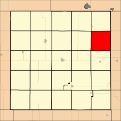 Location in Jewell County | |
| Coordinates: 39°51′19″N 97°58′06″W / 39.85528°N 97.96833°WCoordinates: 39°51′19″N 97°58′06″W / 39.85528°N 97.96833°W | |
| Country | United States |
| State | Kansas |
| County | Jewell |
| Area | |
| • Total | 35.34 sq mi (91.52 km2) |
| • Land | 34.35 sq mi (88.95 km2) |
| • Water | 0.99 sq mi (2.57 km2) 2.81% |
| Elevation | 1,562 ft (476 m) |
| Population (2000) | |
| • Total | 67 |
| • Density | 2/sq mi (0.8/km2) |
| GNIS feature ID | 0471897 |
Sinclair Township is a township in Jewell County, Kansas, USA. As of the 2000 census, its population was 67.
Geography
Sinclair Township covers an area of 35.34 square miles (91.52 square kilometers); of this, 0.99 square miles (2.57 square kilometers) or 2.81 percent is water.
Unincorporated towns
- Lovewell
(This list is based on USGS data and may include former settlements.)
Adjacent townships
- Jackson Township (north)
- Big Bend Township, Republic County (northeast)
- White Rock Township, Republic County (east)
- Courtland Township, Republic County (southeast)
- Grant Township (south)
- Washington Township (southwest)
- Richland Township (west)
- Montana Township (northwest)
Cemeteries
The township contains three cemeteries: Fairview, Laurel Hill and Switzers Gap.
References
External links
Municipalities and communities of Jewell County, Kansas, United States | ||
|---|---|---|
| Cities | 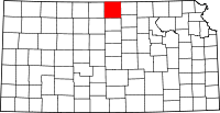 | |
| Unincorporated communities | ||
| Townships | ||
This article is issued from
Wikipedia.
The text is licensed under Creative Commons - Attribution - Sharealike.
Additional terms may apply for the media files.