Otego, Kansas
| Otego, Kansas | |
|---|---|
| Unincorporated community | |
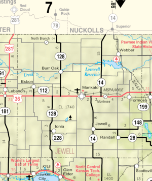 KDOT map of Jewell County (legend) | |
 Otego  Otego | |
| Coordinates: 39°49′38″N 98°20′50″W / 39.82722°N 98.34722°WCoordinates: 39°49′38″N 98°20′50″W / 39.82722°N 98.34722°W[1] | |
| Country | United States |
| State | Kansas |
| County | Jewell |
| Elevation[1] | 1,795 ft (547 m) |
| Time zone | UTC-6 (CST) |
| • Summer (DST) | UTC-5 (CDT) |
| Area code | 785 |
| FIPS code | 20-53500 [1] |
| GNIS ID | 484588 [1] |
Otego is an unincorporated community in Jewell County, Kansas, United States.[2]
History
A post office was opened in Otego in 1887, and remained in operation until it was discontinued in 1954.[3]
References
- 1 2 3 4 Geographic Names Information System (GNIS) details for Otego, Kansas; United States Geological Survey (USGS); October 13, 1978.
- ↑ "Otego". Geographic Names Information System. United States Geological Survey.
- ↑ "Kansas Post Offices, 1828-1961, page 2 (archived)". Kansas Historical Society. Retrieved 11 June 2014.
External links
Municipalities and communities of Jewell County, Kansas, United States | ||
|---|---|---|
| Cities | 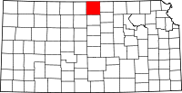 | |
| Unincorporated communities | ||
| Townships | ||
This article is issued from
Wikipedia.
The text is licensed under Creative Commons - Attribution - Sharealike.
Additional terms may apply for the media files.