Montrose, Kansas
| Montrose, Kansas | |
|---|---|
| Unincorporated community | |
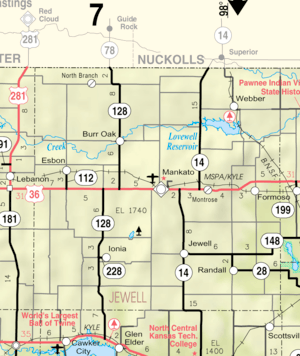 KDOT map of Jewell County (legend) | |
 Montrose  Montrose | |
| Coordinates: 39°47′4″N 98°5′16″W / 39.78444°N 98.08778°WCoordinates: 39°47′4″N 98°5′16″W / 39.78444°N 98.08778°W[1] | |
| Country | United States |
| State | Kansas |
| County | Jewell |
| Elevation[1] | 1,644 ft (501 m) |
| Time zone | UTC-6 (CST) |
| • Summer (DST) | UTC-5 (CDT) |
| Area code | 785 |
| FIPS code | 20-48000 [1] |
| GNIS ID | 472005 [1] |
Montrose is an unincorporated community in Jewell County, Kansas, United States.[2]
History
A post office was first established as Delta in 1880, and the settlement was moved to the current site with the arrival of the Rock Island Railroad, and it was renamed Montrose in 1888.[3][4] The origin of the name Montrose is obscure.[5]
References
- 1 2 3 4 Geographic Names Information System (GNIS) details for Montrose, Kansas; United States Geological Survey (USGS); October 13, 1978.
- ↑ "Montrose, Kansas". Geographic Names Information System. United States Geological Survey.
- ↑ "Kansas Post Offices, 1828-1961". Kansas Historical Society. Retrieved 11 June 2014.
- ↑ "Kansas Post Offices, 1828-1961, page 2 (archived)". Kansas Historical Society. Retrieved 11 June 2014.
- ↑ "Montrose memories". The Superior Express. Jan 25, 2007. pp. 5B. Retrieved 18 October 2015.
External links
Municipalities and communities of Jewell County, Kansas, United States | ||
|---|---|---|
| Cities | 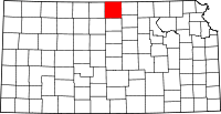 | |
| Unincorporated communities | ||
| Townships | ||
This article is issued from
Wikipedia.
The text is licensed under Creative Commons - Attribution - Sharealike.
Additional terms may apply for the media files.