Erving Township, Jewell County, Kansas
| Erving Township | |
|---|---|
| Township | |
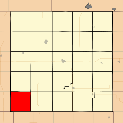 Location in Jewell County | |
| Coordinates: 39°36′08″N 98°27′16″W / 39.60222°N 98.45444°WCoordinates: 39°36′08″N 98°27′16″W / 39.60222°N 98.45444°W | |
| Country | United States |
| State | Kansas |
| County | Jewell |
| Area | |
| • Total | 35.94 sq mi (93.1 km2) |
| • Land | 35.92 sq mi (93.03 km2) |
| • Water | 0.03 sq mi (0.07 km2) 0.08% |
| Elevation | 1,578 ft (481 m) |
| Population (2000) | |
| • Total | 60 |
| • Density | 1.7/sq mi (0.6/km2) |
| GNIS feature ID | 0472084 |
Erving Township is a township in Jewell County, Kansas, USA. As of the 2000 census, its population was 60.
History
Erving Township was organized in 1872. It was named for one Dr. Erving, an early settler and native of Hiawatha.[1]
Geography
Erving Township covers an area of 35.94 square miles (93.1 square kilometers); of this, 0.03 square miles (0.07 square kilometers) or 0.08 percent is water.
Adjacent townships
- Odessa Township (north)
- Ionia Township (northeast)
- Athens Township (east)
- Cawker Township, Mitchell County (south)
- Ross Township, Osborne County (southwest)
- Lincoln Township, Smith County (west)
- Webster Township, Smith County (northwest)
Cemeteries
The township contains two cemeteries: Reformed and Rooker.
References
- ↑ "1878 History of Jewell County, Kansas". Blue Skyways (State Library of Kansas). Retrieved 30 December 2013.
External links
Municipalities and communities of Jewell County, Kansas, United States | ||
|---|---|---|
| Cities | 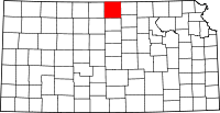 | |
| Unincorporated communities | ||
| Townships | ||
This article is issued from
Wikipedia.
The text is licensed under Creative Commons - Attribution - Sharealike.
Additional terms may apply for the media files.