Shawmut station
SHAWMUT | |||||||||||
|---|---|---|---|---|---|---|---|---|---|---|---|
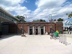 1928-built Shawmut station headhouse with 2009-added elevator shafts at the sides | |||||||||||
| Location | Dayton Street between Centre Street and Lyndhurst Street, Dorchester, Massachusetts | ||||||||||
| Coordinates | 42°17′37″N 71°03′57″W / 42.29371°N 71.065912°WCoordinates: 42°17′37″N 71°03′57″W / 42.29371°N 71.065912°W | ||||||||||
| Owned by | Massachusetts Bay Transportation Authority | ||||||||||
| Line(s) | |||||||||||
| Platforms | 2 side platforms | ||||||||||
| Tracks | 2 | ||||||||||
| Construction | |||||||||||
| Structure type | Subway | ||||||||||
| Disabled access | Yes | ||||||||||
| History | |||||||||||
| Opened | 1872 (original station); September 1, 1928 (rapid transit) | ||||||||||
| Closed | 1926 (original station) | ||||||||||
| Rebuilt | 1981, 2004-2009 | ||||||||||
| Previous names | Melville Avenue and Centre Street (pair of Shawmut Branch Railroad stations) | ||||||||||
| Traffic | |||||||||||
| Passengers (2013) | 2,411 (weekday average boardings)[1] | ||||||||||
| Services | |||||||||||
| |||||||||||
Shawmut is a subway station in Boston, Massachusetts. It serves the Ashmont branch of the MBTA's Red Line. It is located on Dayton Street in the Dorchester neighborhood. The station, the only underground station on the Red Line south of Andrew station, sits in a shallow cut-and-cover subway tunnel that runs from Park Street south to Peabody Square where it surfaces at Ashmont station. Shawmut opened along with Ashmont on September 1, 1928 as part of a southward extension of the Cambridge-Dorchester Line.[2]
History
Shawmut Branch Railroad

In 1872, the Old Colony Railroad took over the Shawmut Branch Railroad, which branched off the main line at Harrison Square and ran through Dorchester to Milton.[3] The branch line originally included stations at Melville Avenue and Centre Street, just one-quarter mile apart, which were consolidated into Shawmut station on October 11, 1884.[4][5][6] Shawmut station was located between Mather and Centre streets on the east side of the tracks.[7]
The New York, New Haven and Hartford Railroad acquired the Old Colony and took over operations in 1893.[8] In 1924, the Boston Elevated Railway bought the Shawmut Branch Railroad and part of the Milton Branch in preparation for extending the Cambridge-Dorchester Line, although New Haven trains ran on the line until 1926.[3]
Rapid transit conversion
The Shawmut Branch reopened as a rapid transit extension in two sections: to Fields Corner (with intermediate stops along the Old Colony mainline at Columbia and Savin Hill) in November 1927, then further to Ashmont with an intermediate stop at Shawmut on September 1, 1928.[2] The Cambridge-Dorchester Line became the Red Line in August 1965.[2]
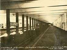
The station was retrofitted in 1981 to accommodate six-car trains, which started service in 1988.[2] The station was originally built with 420-foot platforms, making in the only pre-WWII station on the line designed for six-car trains.[9]
Beginning in 2004, the station was renovated as part of the Red Line Rehabilitation Project. Extensions in the original style were built on both sides of the headhouse to accommodate redundant elevators for handicapped accessibility, required by the Americans with Disabilities Act of 1990. The historic headhouse and platforms were also restored, and new landscaping built around the station for walkability and noise control.[10] The modernization was completed in 2009.[11]
Station layout

Shawmut station has two side platforms serving the line's two tracks. The headhouse connects the two platforms and serves as a free crossover between them, with two elevators from the paid lobby to each platform. Emergency exits near the south end of the platforms lead to small brick buildings on the entrance plaza.
| G | Street Level | Exit/Entrance, headhouse |
| P Platform level |
Side platform, doors will open on the right | |
| Outbound | ← Red Line toward Ashmont (Terminus) | |
| Inbound | → Red Line toward Alewife (Fields Corner) → | |
| Side platform, doors will open on the right | ||
Bus connections
Shawmut does not have any direct bus connections because the station is located in a residential neighborhood away from major streets. It is one of a small number of MBTA heavy rail subway stations without direct bus connections. The nearest buses are the 22, 23, and 26 three blocks west out of Codman Square, and the 18 two blocks east on Dorchester Avenue. Ashmont, one station to the south, and Fields Corner, one station to the north, are both major bus transfer points.
References
- ↑ "Ridership and Service Statistics" (PDF) (14th ed.). Massachusetts Bay Transportation Authority. 2014.
- 1 2 3 4 Belcher, Jonathan (April 23, 2012). "Changes to Transit Service in the MBTA district" (PDF). NETransit. Retrieved May 26, 2012.
- 1 2 Karr, Ronald Dale (2010). Lost Railroads of New England (Third ed.). Branch Line Press. p. 105. ISBN 9780942147117.
- ↑ Cheney, Frank (2002). Boston's Red Line: Bridging the Charles from Alewife to Braintree. Arcadia Publishing. p. 90. ISBN 9780738510477.
- ↑ "Part of Ward 16, Dorchester". Atlas of County of Suffolk, MA Vol. 3. G.M. Hopkins & Co. 1874 – via Ward Maps.
- ↑ Jacobs, Warren (October 1928). "Dates of Some of the Principal Events in the History of 100 Years of the Railroad in New England. 1826-1926". Railway and Locomotive Historical Society Bulletin. Railway and Locomotive Historical Society. 17: 15–28. JSTOR 43504499.
- ↑ "Part of Ward 24, Dorchester, City of Boston". Atlas of the City of Boston, Vol. 5. 1889 – via Ward Maps.
- ↑ Leo S. (December 26, 2009). "Railroad Stations in Dorchester". Dorchester Atheneum. Retrieved May 10, 2012.
- ↑ O'Regan, Gerry (2005). "MBTA Red Line". nycsubway.org. Retrieved May 26, 2012.
- ↑ "MBTA Shawmut Station: Architectural design for restoration of historic subway station headhouse and improvements to platforms". Cambridge Seven Associates. Retrieved October 19, 2015.
- ↑ "Governor Patrick Celebrates Ashmont Station Completion". Massachusetts Department of Transportation. October 21, 2011. Retrieved October 19, 2015.
External links
| Wikimedia Commons has media related to Shawmut (MBTA station). |
- MBTA – Shawmut Station
- Cambridge Seven Associates project page
- Dayton Avenue entrance from Google Maps Street View