Wollaston station
WOLLASTON | |||||||||||||
|---|---|---|---|---|---|---|---|---|---|---|---|---|---|
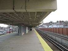
 Looking outbound on Wollaston's brutalist-style platform | |||||||||||||
| Location |
Newport Avenue and Beale Street Wollaston, Quincy, Massachusetts | ||||||||||||
| Coordinates | 42°15′56″N 71°01′10″W / 42.265638°N 71.01953°WCoordinates: 42°15′56″N 71°01′10″W / 42.265638°N 71.01953°W | ||||||||||||
| Owned by | MBTA | ||||||||||||
| Line(s) | |||||||||||||
| Platforms | 1 island platform | ||||||||||||
| Tracks |
2 (Red Line) 1 (Commuter Rail) | ||||||||||||
| Construction | |||||||||||||
| Parking | 550 spaces ($5.00 fee)[1] | ||||||||||||
| Bicycle facilities |
88 spaces in "Pedal and Park" bicycle cage ~20 outside spaces[1] | ||||||||||||
| History | |||||||||||||
| Opened | November 1845 (original station), September 1, 1971 (rapid transit)[2] | ||||||||||||
| Closed | June 30, 1959 (original station), January 8, 2018 (rapid transit, temporarily) | ||||||||||||
| Rebuilt | 2017–2020 | ||||||||||||
| Previous names | Wollaston Heights (former station) | ||||||||||||
| Traffic | |||||||||||||
| Passengers (2013 daily) | 4,624[3] | ||||||||||||
| Services | |||||||||||||
| |||||||||||||
| |||||||||||||
Wollaston is a temporarily closed rapid transit station in Quincy, Massachusetts. Located in the Wollaston neighborhood, it serves the MBTA's Red Line. It was opened in September 1971 as the second of three stations in the original South Shore Extension, replacing a mainline rail station which had been located there from 1845 to 1959.[2] As of January 8th, 2018, Wollaston is closed until the summer of 2019 for renovations to the station, including flooding mitigation and adding elevator access.[1] [4] Wollaston station serves Eastern Nazarene College, which is 0.5 miles (0.80 km) away.
History
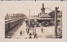
The Old Colony Railroad opened through Quincy in November 1845.[5] Several local stations were located in Quincy, including Wollaston station (also known as Wollaston Heights) at Beale Street. In 1877, a large station with a clock tower was built on the west (inbound) side of the tracks.[6] The Old Colony switched from English-style left-hand running to American-style right-hand running in 1893 when it was acquired by the New York, New Haven and Hartford Railroad; the depot was moved to the east side of the tracks in 1895.[5][7][8]
Passenger service on the Old Colony system declined after World War II, and the New Haven decided to abandon the line in the late 1950s. Emergency subsidies kept the lines open during construction of the Southeast Expressway, but all passenger service to Wollaston and the rest of the former Old Colony system was ended on June 30, 1959.[5]
Even before 1959, discussion was underway to bring rapid transit to the Old Colony mainline. The 1926 Report on Improved Transportation Facilities and 1945–47 Coolidge Commission Report recommended a branch of the Cambridge-Dorchester Line (later renamed as the Red Line) to parallel the Old Colony mainline to Braintree, taking over service on local stops.[9][10] The newly formed MBTA bought the Old Colony right-of-way from South Boston to South Braintree in 1965.[5] In 1966, the Program for Mass Transportation recommended the extension, and construction of the station began that year. Wollaston opened along with North Quincy and Quincy Center on September 1, 1971.[2]
Station layout
| P Platform level |
Inbound | ← Red Line does not stop here (North Quincy) |
| Island platform, not in service | ||
| Outbound | → Red Line does not stop here (Quincy Center) → | |
| Commuter rail track | ← Commuter rail lines/CapeFLYER do not stop here → | |
| G | Street Level | Exit/Entrance |
| L | Lobby | Fare control, to entrances/exits |

The main entrance to the station is via the large parking lot off Beale Avenue. An additional entrance is located on Newport Avenue. The station, located on a high grade, is one of a small number of elevated rapid transit stations remaining in the MBTA system. (The only others are Science Park, Malden Center, Charles/MGH, Beachmont and Fields Corner.) Boston once had several elevated lines, but the Atlantic Avenue Elevated, Charlestown Elevated, Washington Street Elevated and Causeway Street Elevated were all closed and torn down in sequence from 1938 to 2004 in favor of subway and surface-level lines.
Although the platform is elevated, the station lobby and turnstiles are actually situated several feet below street level, making the lobby prone to flooding during heavy rainstorms. On July 25, 1988, the lobby was flooded by an afternoon deluge, stranding around 100 riders at the station.[11]
When the station was built, return of commuter service to the right-of-way was considered unlikely and few provisions were made. Only a single non-rapid-transit track for freight service was left on the narrow grade. Commuter service, however, returned on the Old Colony Lines beginning in 1997 and on the Greenbush Line beginning in 2007. Because of the limited width of the elevated grade and right-of-way through densely populated Quincy, adding a second commuter rail track would be extremely difficult. The single-tracked section of the line around Wollaston represents a major bottleneck on the commuter rail system serving the South Shore.
Planned renovations
The Red Line's Braintree Extension was built several decades before the 1990 Americans with Disabilities Act and not all of the stations were originally handicapped-accessible. All other stations on the Red Line proper - and all except Valley Road on the Ashmont–Mattapan High Speed Line - have been rebuilt or retrofitted for handicapped accessibility. The MBTA is planning renovations to Wollaston that will make it handicapped-accessible and solve the flooding problems. Design reached 15% in July 2014, 30% in mid-2015, and 60% in early 2016.[12]
The 30% design planned for accessible headhouses at each end of the station, with pedestrian bridges crossing over the inbound track to connect the headhouses to the platform, but the 60% design revised this to a single larger headhouse.[13] The current lobby area will be converted to an accessible passageway between the parking lots and Newport Avenue, with a separate fare payment area and elevator to the platform.[14] 100% design was reached in July 2016.[12] Bidding for the estimated $71.6 million main contract (which includes demolition of the Quincy Center garage) took place from April to June 2017; a $67.867 million contract was approved on June 19.[15] The construction work was originally set to be done from July 2017 to June 2020; it will require the station to be closed for 20 months starting January 8, 2018, with bus shuttles to North Quincy station.[16] The closure of Wollaston to permit the required ADA access specifications to be met has been delayed to permit the Wollaston station work to coincide with the start of demolition work on the Quincy Center station closed parking garage towards the construction of its replacement.[17][18] The station was closed on January 8, 2018, with bus shuttles running from North Quincy and Quincy Center stations, stopping in between at Wollaston. The closure is expected to last until the summer of 2019.
Bus connections
Two bus routes stop directly at Wollaston station on Newport Avenue:
- 211 Quincy Center Station - Squantum via Montclair & North Quincy Station
- 217 Quincy Center Station - Ashmont Station via Beale Street, Wollaston, & East Milton Square
Two additional bus routes stop on Hancock Street several blocks to the east:
- 210 Quincy Center Station - North Quincy Station or Fields Corner Station via Hancock Street & Neponset Avenue
- 212 Quincy Center Station - North Quincy Station via Billings Road
References
- 1 2 3 "Wollaston Station". Massachusetts Bay Transportation Authority. Retrieved 17 January 2012.
- 1 2 3 Belcher, Jonathan (31 December 2011). "Changes to Transit Service in the MBTA district" (PDF). NETransit. Retrieved 17 January 2012.
- ↑ "Ridership and Service Statistics" (PDF) (14th ed.). Massachusetts Bay Transportation Authority. 2014.
- ↑ https://www.mbta.com/projects/3004 |accessdate=2 November 2017
- 1 2 3 4 Karr, Ronald Dale (1995). The Rail Lines of Southern New England. Branch Line Press. pp. 310–315. ISBN 0942147022.
- ↑ "Quincy". Topographical Atlas of Massachusetts. Walker Lithograph & Publishing Co. 1891. Retrieved 24 January 2013.
- ↑ Cheney, Frank (2002). Boston's Red Line: Bridging the Charles from Alewife to Braintree. Arcadia Publishing. p. 111. ISBN 9780738510477.
- ↑ "Index Plate". Atlas of the City of Quincy. Ernest Branch. 1907. Retrieved 24 January 2013.
- ↑ Central Transportation Planning Staff (15 November 1993). "The Transportation Plan for the Boston Region - Volume 2". National Transportation Library. Retrieved 24 January 2013.
- ↑ Boston Elevated Railway and Boston Department of Public Utilities (1945). "Boston Rapid Transit System & Proposed Extentions [sic] 1945 - Metropolitan Transit Recess Commission Air View". Wardmaps LLC. Retrieved 24 January 2013.
- ↑ Moskowitz, Eric (18 November 2012). "Starts and Stops: MBTA receives first of long-delayed rail cars". Boston Globe. Retrieved 18 November 2012.
- 1 2 "Wollaston Station Improvements". Massachusetts Bay Transportation Authority. Retrieved 4 March 2016.
- ↑ "MBTA WOLLASTON Station Improvements Public Meeting: June 2, 2015" (PDF). Massachusetts Bay Transportation Authority. 2 June 2015. Retrieved 24 June 2015.
- ↑ Kleinfelder, Inc. (14 January 2016). "MBTA Wollaston Station Improvements Public Meeting" (PDF). Massachusetts Bay Transportation Authority. Retrieved 4 March 2016.
- ↑ "Construction Contract A47CN01: Wollaston Station Improvements and Quincy Center Garage Demolition" (PDF). Massachusetts Bay Transportation Authority. June 19, 2017.
- ↑ "MBTA Red Line Corridor Improvements: Public Meetings Set". MassDOT Blog (Press release). Massachusetts Department of Transportation. March 31, 2017.
- ↑ Yee, Erica (September 14, 2017). "Wollaston T station closure delayed until December". Boston Globe. Retrieved October 27, 2017.
- ↑ "Construction Contract A47CN01: Wollaston Station Improvements and Quincy Center Garage Demolition" (PDF). Massachusetts Bay Transportation Authority. June 19, 2017.
External links
| Wikimedia Commons has media related to Wollaston (MBTA station). |
- MBTA - Wollaston
- MBTA - Wollaston accessibility project
- Brook Street and Newport Avenue entrance from Google Maps Street View
| Neighborhoods |  | |
|---|---|---|
| Schools | ||
| Colleges and universities | ||
| Landmarks | ||
| Media | ||
| MBTA stations | ||
| Islands | ||
| History | ||
| ||