Reservoir station (MBTA)
RESERVOIR | |||||||||||||
|---|---|---|---|---|---|---|---|---|---|---|---|---|---|
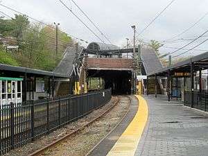 Platforms at Reservoir station in May 2016 | |||||||||||||
| Location |
Chestnut Hill Avenue near Clinton Road Brookline, Massachusetts | ||||||||||||
| Coordinates | 42°20′07″N 71°8′53″W / 42.33528°N 71.14806°WCoordinates: 42°20′07″N 71°8′53″W / 42.33528°N 71.14806°W | ||||||||||||
| Owned by | Massachusetts Bay Transportation Authority | ||||||||||||
| Line(s) |
Green Line "D" branch | ||||||||||||
| Platforms | 4 side platforms (2 in regular service) | ||||||||||||
| Tracks | 4 (2 in regular service) | ||||||||||||
| Construction | |||||||||||||
| Bicycle facilities | 8 spaces | ||||||||||||
| Disabled access | Yes | ||||||||||||
| History | |||||||||||||
| Opened |
November 1852 (commuter rail) July 4, 1959 (light rail) | ||||||||||||
| Closed | May 31, 1958 (commuter rail)[1] | ||||||||||||
| Traffic | |||||||||||||
| Passengers (2011) | 3,404 (weekday average boardings)[2] | ||||||||||||
| Services | |||||||||||||
| |||||||||||||
| |||||||||||||
Reservoir is a surface station on the MBTA's Green Line "D" Branch, located on the border of Boston and Brookline, Massachusetts near Cleveland Circle. The station is adjacent to Reservoir Yard and Carhouse, with the Cleveland Circle terminus of the "C" Branch just a block away. With a daily ridership of 3,395, Reservoir is the second-busiest surface stop on the "D' Branch (after Brookline Village).[2]
Reservoir station is handicapped accessible, with raised platforms to accommodate low-floor trams.
History
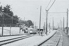
Brighton Street opened as a commuter rail station on the Charles River Branch Railroad (by then merged into the Charles River Railroad) in November 1852. The station was located on the north side of the tracks east of Brighton Street (later Chestnut Hill Avenue).[3] The station was moved west of Chestnut Hill Avenue and renamed Reservoir around the time the Chestnut Hill Reservoir opened in 1870.[4][5] In 1883, the Boston and Albany Railroad bought the line between Brookline Junction and Cook Junction and extended it to Reservoir as its Highland Branch, running Newton Circuit service beginning in 1886.[6] A Richardsonian Romanesque station building, designed by Shepley, Rutan and Coolidge, opened in 1888 near the original station location.[7]
On May 31, 1958, the line was closed for rebuilding; it reopened on July 4, 1959 as a branch of the M.T.A. streetcar system.[1][8] The 1888 station building was removed to make space for the new station and connecting yard tracks.[9] When the line was converted for light rail use, it was assumed that most traffic would come from the inner part of the line, and thus an overhead loop was built connecting the line to Chestnut Hill Avenue. However, the outer half of the line proved more popular than expected, and Reservoir short turns were later reduced, with some extra short turn service remaining at times during rush hour.[8]
In 1974, the MBTA began rebuilding the line to accommodate the new Boeing LRVs. From June 8 to September 11, Highland Branch cars ran on Beacon Street from Reservoir to Kenmore. A temporary inbound-to-outbound turning loop was built east of Reservoir for the diversion. Inbound cars stopped at Reservoir, ran around the temporary loop, and up the outbound side of the regular loop towards Cleveland Circle. Outbound cars via Beacon Street ran down the inbound side of the regular loop, around the same temporary loop track, and then continued outbound from the station.[8]
The regular short-turn loop was closed in August 1980 as part of the closure of the old Reservoir Carhouse, which had been built in 1889 when the Beacon Street line opened.[8][10] The old carhouse closed on June 25, 1982; a new building opened the next year.[8]
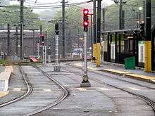
The regular station, located below grade, has two side platforms serving the line's 2 tracks. A two-track spur with two side platforms of its own runs north of the main station and connects with the non-revenue tracks on Chestnut Hill Avenue. This spur, built after the loop removal in 1980, is sometimes used to detrain passengers from cars short-turning at Reservoir so as not to block the main tracks. A sidewalk ramp runs alongside the spur line, serving as a handicapped-accessible route to the station platforms from the north.
Station layout
| G Platform level |
Side platform, not in service | |
| Outbound | →No regular service (No service: Cleveland Circle) | |
| Inbound | → "D" Branch toward Government Center (Beaconsfield) → | |
| Side platform, doors will open on the right | ||
| Side platform, doors will open on the right | ||
| Outbound | ← "D" Branch toward Riverside (Chestnut Hill) | |
| Inbound | → "D" Branch toward Government Center (Beaconsfield) → | |
| Side platform, doors will open on the right | ||
Bus connections
Two MBTA Bus routes terminate at the Reservoir busway off Chestnut Hill Avenue:
- 51 Cleveland Circle - Forest Hills Station via Hancock Village
- 86 Sullivan Square Station - Reservoir (Cleveland Circle) via Harvard/Johnston Gate
References
- 1 2 Humphrey, Thomas J.; Clark, Norton D. (1985). Boston's Commuter Rail: The First 150 Years. Boston Street Railway Association. p. 24. ISBN 9780685412947.
- 1 2 "Ridership and Service Statistics" (PDF) (14 ed.). Massachusetts Bay Transportation Authority. 2014. Retrieved 9 May 2016.
- ↑ "Brookline in 1855". Brookline Historical Society. 1923.
- ↑ "Aberdeen Architectural Conservation District: Boston Landmarks Commission Study Report" (PDF). Boston Landmarks Commission Environment Department. January 2002. p. 21.
- ↑ "Part of the town of Brookline, Massachusetts". Atlas of The Town of Brookline. G.M. Hopkins & Co. 1874 – via Ward Maps.
- ↑ Karr, Ronald Dale (1995). The Rail Lines of Southern New England. Branch Line Press. pp. 288–289. ISBN 0942147022.
- ↑ Morgan, Keith N., Cushing, Elizabeth Hope, and Reed, Roger (2009). "Appendix VI: The Brookline projects of Shepley, Rutan and Coolidge" (PDF). Community by Design: The Role of the Frederick Law Olmsted Office in the Suburbanization of Brookline, Massachusetts, 1880 to 1936. Boston University. Retrieved 18 February 2013.
- 1 2 3 4 5 Belcher, Jonathan (19 March 2016). "Changes to Transit Service in the MBTA district 1964-2016" (PDF). NETransit. Retrieved 9 May 2016.
- ↑ Cheney, Frank & Sammarco, Anthony M. (1997). Trolleys Under the Hub. Arcadia Publishing. p. 93. ISBN 0752409077.
- ↑ Clarke, Bradley H. (2003). Streetcar Lines of the Hub - The 1940s. Boston Street Railway Association. p. 99. ISBN 0938315056.
External links
| Wikimedia Commons has media related to Reservoir station (MBTA). |