Boston College station
BOSTON COLLEGE | |||||||||||
|---|---|---|---|---|---|---|---|---|---|---|---|
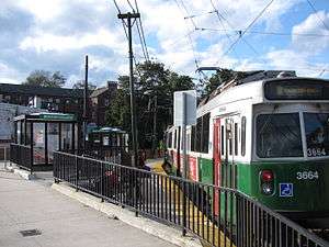 Inbound train at Boston College station in 2011 | |||||||||||
| Location |
Commonwealth Avenue at Lake Street Boston and Newton, Massachusetts | ||||||||||
| Coordinates | 42°20′24.3″N 71°10′1.2″W / 42.340083°N 71.167000°WCoordinates: 42°20′24.3″N 71°10′1.2″W / 42.340083°N 71.167000°W | ||||||||||
| Owned by | Massachusetts Bay Transportation Authority | ||||||||||
| Line(s) | |||||||||||
| Platforms | 2 side platforms | ||||||||||
| Tracks | 2 | ||||||||||
| Construction | |||||||||||
| Disabled access | Yes | ||||||||||
| History | |||||||||||
| Opened | 1896 | ||||||||||
| Rebuilt | c. 1916, 1930, 2009 | ||||||||||
| Previous names | Lake Street (until 1947) | ||||||||||
| Traffic | |||||||||||
| Passengers (2011) | 1,136 (weekday inbound boardings)[1] | ||||||||||
| Services | |||||||||||
| |||||||||||
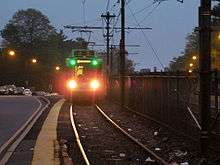
Boston College is a light rail station on the MBTA Green Line "B" Branch. It is located at St. Ignatius Square on the Boston College campus in Brighton, Boston, near the intersection of Commonwealth Avenue and Lake Street. Originally opened in 1896, it has been the terminus of the Commonwealth Avenue line since 1900. The current station is planned to be replaced by a new station located in the median of Commonwealth Avenue just east of Lake Street.
History
Original median station
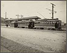
On August 15, 1896, the Boston Elevated Railway (BERy) added tracks on newly constructed Commonwealth Avenue from the Newton town line east to Chestnut Hill Avenue, where they were connected to the existing Beacon Street Line at Cleveland Circle.[2] Except for rights to the Watertown Line inherited from the West End Street Railway, the BERy did not have operating rights in Newton. Instead, the Commonwealth Avenue Street Railway was built westward on the wide median of Commonwealth Avenue to Auburndale in 1895.[3] It was soon taken over and operated by the Middlesex and Boston Street Railway (M&B). The two lines met at Lake Street station on the town line.[2]
BERy cars from Lake Street began running into the Tremont Street Subway via Beacon Street when the subway opened on September 1, 1897. On May 26, 1900, tracks on Commonwealth Avenue were completed from Chestnut Hill Avenue to Packards Corner, at which point Lake Street became the terminus of the Commonwealth Avenue line, which also ran into the subway.[2] Except for occasional service disruptions due to track work or blockages on Commonwealth Avenue, Boston College has been the terminus of the Commonwealth Avenue line ("B" Branch) since 1900.[2]
Move to the north

Around 1916, the BERy constructed a yard on the north side of Commonwealth Avenue just west of Lake Street; however, it continued to share the median station with the M&B.[4][5][6] On November 20, 1918, an out-of-service BERY streetcar rolled down a hill and destroyed the station, killing a waiting passenger.[7]
The M&B line was bustituted in 1930, and the BERy no longer needed the old median station. A platform and waiting room in the yard opened on September 12, 1930.[2] The M&B used a bus stop adjacent to the new inbound platform.[8] The station was renamed to Boston College on May 21, 1947 by vote of the Boston Elevated Railway trustees after Boston College bought adjacent land for their Newton campus.[8]
On May 23, 1979, the MBTA opened a new carhouse at the Lake Street yard. The carhouse provides light maintenance services to reduce the load on Reservoir and Riverside.[9][2] Around this time, platforms were constructed along the median east of Lake Street. Not a separate station, they were used when congestion in the yard (common with the introduction of the new Boeing LRVs) prevented trains from entering or exiting. The eastbound of these platforms, and a bus shelter on the westbound side, were removed during a 1980-81 renovation of the line.[10]
New station
In 2007, Boston College released its 10 Year Institutional Master Plan, which includes a plan to relocate the station to the median of Commonwealth Avenue, just east of the Lake Street intersection. The college later agreed to aid the project financially and to donate land to widen Commonwealth Avenue to accommodate the station.[11] A $296,000 temporary accessibility solution with new platforms was built on the existing site in 2009; during construction, temporary platforms were built near Lake Street.[12]
Planning continued for the relocated station. The project was advanced to 15% design by a $656,000 federal grant and $164,500 of MBTA funds.[12] The design was advanced to the 30% level in November 2012 with an environmental review package completed the previous month, but no progress has been made since, due to limited funding. Once funds are made available, the new station is expected to take 24 months to construct at a cost of $20 million.[13]
The new station will have two side platforms, with a narrower platform between the tracks for passengers offloading from outbound trains and a wider platform with canopies for those waiting to board inbound trains.[12] The new station would eliminate streetcars having to cross Commonwealth Avenue traffic to access the platforms, which will reduce moves across Commonwealth by 89%, though streetcars will still need to cross to access the yard.[13] It will have raised platforms for level, handicapped-accessible boarding on newer low-floor streetcars and a ramp for accessible boarding on older high-floor streetcars. (The current station is only accessible for low-floor streetcars.)[14]
Bus connections
Boston College station has not had MBTA Bus connections since the 535 Lake Street - Auburndale route (the direct descendant of the Commonwealth Avenue Street Railway) was discontinued in 1976.[10] Boston College operates a system of private shuttle buses, but they stop on the campus rather than at the station.[15]
References
- ↑ "Ridership and Service Statistics" (PDF) (14th ed.). Massachusetts Bay Transportation Authority. 2014.
- 1 2 3 4 5 6 Clarke, Bradley H.; Cummings, O.R. (1997). Tremont Street Subway: A Century of Public Service. Boston Street Railway Association. pp. 58–59. ISBN 0938315048.
- ↑ Beautiful Newton: The Garden City of Massachusetts. Newton Graphic Publishing Company. p. 26 – via Internet Archive.
- ↑ "Sheet 10". Track Lengths of Surface Lines and Subway. Boston Elevated Railway. 1921 – via Ward Maps.
- ↑ "Part of Ward 6, City of Newton". Atlas of the City of Newton, Massachusetts. G.W. Bromley and Company. 1917 – via Ward Maps.
- ↑ "Part of Brighton, Ward 25, City of Boston". Atlas of the City of Boston, Wards 25 & 26, Brighton. G.W. Bromley and Company. 1916 – via Ward Maps.
- ↑ Annual Report, Part 1. Massachusetts Public Service Commission. 1919. p. 44 – via Google Books.
- 1 2 Clarke, Bradley H. (2003). Streetcar Lines of the Hub. Boston Street Railway Association. p. 99. ISBN 0938315056.
- ↑ Sanborn, George M. (1992). A Chronicle of the Boston Transit System. Massachusetts Bay Transportation Authority – via MIT.
- 1 2 Belcher, Jonathan (27 June 2015). "Changes to Transit Service in the MBTA district 1964-2015" (PDF). NETransit. Retrieved 1 December 2015.
- ↑ "Chapter 9: Transportation and Parking" (PDF). Boston College Institutional Master Plan. Boston College. 20 June 2008. Retrieved 1 January 2013.
- 1 2 3 Rocheleau, Matt (28 September 2012). "MBTA to hold meeting on $20m project to rebuild Boston College Station". Boston Globe. Retrieved 1 January 2013.
- 1 2 "Green Line - Boston College Station". Massachusetts Bay Transportation Authority. Archived from the original on July 19, 2017.
- ↑ Jacobs Engineering (8 August 2012). "MBTA Boston College Station: 15% Design Submittal" (PDF). Massachusetts Bay Transportation Authority. Archived from the original (PDF) on 1 December 2015.
- ↑ "BC Shuttle Bus". Boston College Transportation and Parking Services. Retrieved 1 December 2015.
External links
| Wikimedia Commons has media related to Boston College station. |