Santa Fe, Leyte
| Santa Fe | ||
|---|---|---|
| Municipality | ||
| Municipality of Santa Fe | ||
| ||
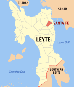 Map of Leyte with Santa Fe highlighted | ||
.svg.png) Santa Fe Location within the Philippines | ||
| Coordinates: 11°11′08″N 124°54′58″E / 11.18556°N 124.91611°ECoordinates: 11°11′08″N 124°54′58″E / 11.18556°N 124.91611°E | ||
| Country |
| |
| Region | Eastern Visayas (Region VIII) | |
| Province | Leyte | |
| District | 1st district of Leyte | |
| Barangays | 20 (see Barangays) | |
| Government [1] | ||
| • Type | Sangguniang Bayan | |
| • Mayor | Melchor M. Quemado Sr. | |
| • Electorate | 12,602 voters (2016) | |
| Area [2] | ||
| • Total | 53.97 km2 (20.84 sq mi) | |
| Population (2015 census)[3] | ||
| • Total | 20,439 | |
| • Density | 380/km2 (980/sq mi) | |
| Time zone | UTC+8 (PST) | |
| ZIP code | 6513 | |
| PSGC | 083744000 | |
| IDD : area code | +63 (0)53 | |
| Climate type | Tropical rainforest climate | |
| Income class | 5th municipal income class | |
| Revenue (₱) | 56,921,144.95 (2016) | |
| Native languages |
Waray Tagalog | |

Santa Fe, officially the Municipality of Santa Fe, is a 5th class municipality in the province of Leyte, Philippines. According to the 2015 census, it has a population of 20,439 people.[3]
Barangays
Santa Fe is politically subdivided into 20 barangays. [2]
- Baculanad
- Badiangay
- Bulod
- Catoogan
- Katipunan (formerly the sitio of Pinanhadsan[4])
- Milagrosa (formerly the sitio of Km. 17[4])
- Pilit
- Pitogo
- Zone 1 (Poblacion)
- Zone 2 (Poblacion)
- Zone 3 (Poblacion)
- San Isidro
- San Juan
- San Miguelay
- San Roque (formerly Curba[5])
- Tibak
- Victoria
- Cutay
- Gapas
- Zone 4 Pob. (Cabangcalan)
Demographics
| Population census of Santa Fe | |||||||||||||||||||||||||||||||||||||
|---|---|---|---|---|---|---|---|---|---|---|---|---|---|---|---|---|---|---|---|---|---|---|---|---|---|---|---|---|---|---|---|---|---|---|---|---|---|
|
| ||||||||||||||||||||||||||||||||||||
| Source: Philippine Statistics Authority [3][6][7][8] | |||||||||||||||||||||||||||||||||||||
In the 2015 census, the population of Santa Fe, Leyte, was 20,439 people,[3] with a density of 380 inhabitants per square kilometre or 980 inhabitants per square mile.
References
- ↑ "Municipality". Quezon City, Philippines: Department of the Interior and Local Government. Retrieved 31 May 2013.
- 1 2 "Province: Leyte". PSGC Interactive. Quezon City, Philippines: Philippine Statistics Authority. Retrieved 12 November 2016.
- 1 2 3 4 Census of Population (2015). "Region VIII (Eastern Visayas)". Total Population by Province, City, Municipality and Barangay. PSA. Retrieved 20 June 2016.
- 1 2 "An Act Converting the Sitios of Pinanhadsan and Km. 17, Municipality of Santa Fe, Province of Leyte, into Barrios of Said Municipality to Be Known As the Barrios of Katipunan and Milagrosa, Respectively". LawPH.com. Retrieved 2011-04-12.
- ↑ "An Act Changing the Name of the Barrio of Curba, Municipality of Santa Fe, Province of Leyte, to Barrio San Roque". LawPH.com. Retrieved 2011-04-12.
- ↑ Census of Population and Housing (2010). "Region VIII (Eastern Visayas)". Total Population by Province, City, Municipality and Barangay. NSO. Retrieved 29 June 2016.
- ↑ Censuses of Population (1903–2007). "Region VIII (Eastern Visayas)". Table 1. Population Enumerated in Various Censuses by Province/Highly Urbanized City: 1903 to 2007. NSO.
- ↑ "Province of Leyte". Municipality Population Data. Local Water Utilities Administration Research Division. Retrieved 17 December 2016.
External links
- Philippine Standard Geographic Code
- Philippine Census Information
- Local Governance Performance Management System
Places adjacent to Santa Fe, Leyte | ||||||||||
|---|---|---|---|---|---|---|---|---|---|---|
| ||||||||||
Tacloban (capital) | |
| Municipalities |
|
| Component city | |
| Independent component city |
|
| Highly urbanized city |
|
This article is issued from
Wikipedia.
The text is licensed under Creative Commons - Attribution - Sharealike.
Additional terms may apply for the media files.