Matalom, Leyte
| Matalom | |
|---|---|
| Municipality | |
| Municipality of Matalom | |
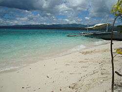 Canigao Island | |
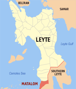 Map of Leyte with Matalom highlighted | |
.svg.png) Matalom Location within the Philippines | |
| Coordinates: 10°17′N 124°48′E / 10.28°N 124.8°ECoordinates: 10°17′N 124°48′E / 10.28°N 124.8°E | |
| Country |
|
| Region | Eastern Visayas (Region VIII) |
| Province | Leyte |
| District | 5th district of Leyte |
| Barangays | 30 (see Barangays) |
| Government [1] | |
| • Type | Sangguniang Bayan |
| • Mayor | Eric S. Pajulio |
| • Electorate | 18,656 voters (2016) |
| Area [2] | |
| • Total | 132.00 km2 (50.97 sq mi) |
| Population (2015 census)[3] | |
| • Total | 33,121 |
| • Density | 250/km2 (650/sq mi) |
| Time zone | UTC+8 (PST) |
| ZIP code | 6526 |
| PSGC | 083734000 |
| IDD : area code | +63 (0)53 |
| Climate type | Tropical rainforest climate |
| Income class | 3rd municipal income class |
| Revenue (₱) | 100,040,346.92 (2016) |
| Native languages |
Cebuano Tagalog |
Matalom, officially the Municipality of Matalom, is a 3rd class municipality in the province of Leyte, Philippines. According to the 2015 census, it has a population of 33,121 people.[3]
Etymology
It was said that the Spaniards once saw the flaming red of the fire trees that dotted the shores of Matalom Beach and the scenic Canigao Island and asked the natives the local dialect for "hermosa" or beautiful. The natives answered "Matahum" or "Matalom." This was the origin of the town's name.
Barangays
Matalom is politically subdivided into 30 barangays. [2]
- Agbanga
- Altavista
- Cahagnaan
- Calumpang
- Caningag
- Caridad Norte
- Caridad Sur
- Elevado
- Esperanza
- Hitoog
- Itum
- Lowan
- Monte Alegre
- Punong
- San Isidro (Poblacion)
- San Pedro (Poblacion)
- San Roque (Poblacion)
- Santo Niño (Poblacion)
- Sta. Fe (Tab-Ang)
- San Juan
- San Salvador
- San Vicente
- Santa Paz
- Tag-os
- Templanza
- Tigbao
- Waterloo
- Zaragoza
- Bagong Lipunan
- Taglibas Imelda
History
Before Ferdinand Magellan discovered the Philippines, a sea-faring people lived along the banks of the Matalom River and also on the islet of Canigao (formerly Comigao).
In the middle of the 18th century, the townspeople of Matalom constructed their own parish church, convent, school, and public buildings through their own efforts. These were all accomplished with the leadership of Spanish Friar Leonardo Celes Diaz and Capitan Calixto Pil believed to be the founder and first president of the town.
Leadership in the town's administration may be divided into three regimes: Spanish, American and Postwar (Philippine Independence). The first president of Matalom during the Spanish regime was Capitan Calixto Pil. Succession to the chair of president was patterned after the original dynasty set up by the natives, by Pal and Pil families. Thus, after Kapitan "Itong" (Cpt. Calixto Pil) his son followed. Next in line was Kapitan "Osting" (Cpt. Agustin Pil) then Kapitan "Kulas" (Cpt. Nicolas Pal), then Kapitan "Bentoy" (Cpt. Ruberto Pal), the last president before the transition period from Spanish to American regimes. The council members were then called, "Guinhaupan," acknowledged leader in settlements, now barrios or sitios.
The transition from the American regime to the time the Philippines obtained its independence saw Jeremias Pal re-elected alcalde in 1937 until the outbreak of World War II. The dark days of the Japanese occupation had Antonio Olo as the "puppet mayor". The restoration of the civil government after the war saw the appointment of Primitivo Gopo as the municipal mayor of Matalom.
Demographics
| Population census of Matalom | |||||||||||||||||||||||||||||||||||||||||||||||||
|---|---|---|---|---|---|---|---|---|---|---|---|---|---|---|---|---|---|---|---|---|---|---|---|---|---|---|---|---|---|---|---|---|---|---|---|---|---|---|---|---|---|---|---|---|---|---|---|---|---|
|
| ||||||||||||||||||||||||||||||||||||||||||||||||
| Source: Philippine Statistics Authority [3][4][5][6] | |||||||||||||||||||||||||||||||||||||||||||||||||
In the 2015 census, the population of Matalom was 33,121 people,[3] with a density of 250 inhabitants per square kilometre or 650 inhabitants per square mile.
Tourism
Matalom has become famous for Canigao Island.
References
- ↑ "Municipality". Quezon City, Philippines: Department of the Interior and Local Government. Retrieved 31 May 2013.
- 1 2 "Province: Leyte". PSGC Interactive. Quezon City, Philippines: Philippine Statistics Authority. Retrieved 12 November 2016.
- 1 2 3 4 Census of Population (2015). "Region VIII (Eastern Visayas)". Total Population by Province, City, Municipality and Barangay. PSA. Retrieved 20 June 2016.
- ↑ Census of Population and Housing (2010). "Region VIII (Eastern Visayas)". Total Population by Province, City, Municipality and Barangay. NSO. Retrieved 29 June 2016.
- ↑ Censuses of Population (1903–2007). "Region VIII (Eastern Visayas)". Table 1. Population Enumerated in Various Censuses by Province/Highly Urbanized City: 1903 to 2007. NSO.
- ↑ "Province of Leyte". Municipality Population Data. Local Water Utilities Administration Research Division. Retrieved 17 December 2016.
External links
| Wikivoyage has a travel guide for Matalom. |
- Philippine Standard Geographic Code
- Philippine Census Information
- Local Governance Performance Management System
Places adjacent to Matalom, Leyte | |
|---|---|
Tacloban (capital) | |
| Municipalities |
|
| Component city | |
| Independent component city |
|
| Highly urbanized city |
|