Calubian, Leyte
| Calubian | |
|---|---|
| Municipality | |
| Municipality of Calubian | |
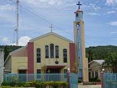
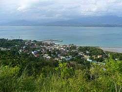 Hilltop view of Calubian | |
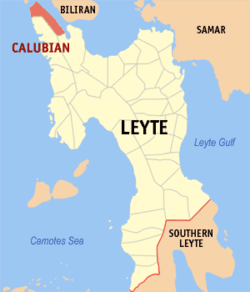 Map of Leyte with Calubian highlighted | |
.svg.png) Calubian Location within the Philippines | |
| Coordinates: 11°27′N 124°25′E / 11.45°N 124.42°ECoordinates: 11°27′N 124°25′E / 11.45°N 124.42°E | |
| Country |
|
| Region | Eastern Visayas (Region VIII) |
| Province | Leyte |
| District | 3rd district of Leyte |
| Barangays | 53 (see Barangays) |
| Government [1] | |
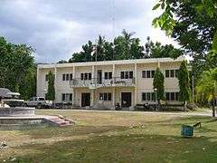
| • Type | Sangguniang Bayan |
| • Mayor | Doroteo Palconit |
| • Electorate | 20,822 voters (2016) |
| Area [2] | |
| • Total | 100.95 km2 (38.98 sq mi) |
| Population (2015 census)[3] | |
| • Total | 31,228 |
| • Density | 310/km2 (800/sq mi) |
| Time zone | UTC+8 (PST) |
| ZIP code | 6534 |
| PSGC | 083713000 |
| IDD : area code | +63 (0)53 |
| Climate type | Tropical rainforest climate |
| Income class | 4th municipal income class |
| Revenue (₱) | 80,836,473.98 (2016) |
| Native languages |
Cebuano Tagalog |
Calubian, officially the Municipality of Calubian, is a 4th class municipality in the province of Leyte, Philippines. According to the 2015 census, it has a population of 31,228 people.[3]
Barangays
Calubian is politically subdivided into 53 barangays.
- Abanilla
- Anislagan
- Bunacan
- Cabalquinto
- Herrera (Cabalhin)
- Cabradilla
- Caneja
- Cantonghao
- Caroyocan
- Casiongan
- Cristina
- Dalumpines
- Don Luis
- Dulao
- Efe (Ul-og)
- Enage
- Espinosa
- Ferdinand E. Marcos
- Garganera
- Garrido
- Guadalupe
- Gutosan
- Igang
- Inalad
- Jubay
- Juson
- Kawayan Bogtong
- Kawayanan
- Labtic
- Laray
- Limite (Agas)
- M. Veloso
- Mahait
- Malobago
- Matagok
- Nierras
- Nipa
- Obispo
- Pagatpat
- Pangpang
- Patag
- Pates
- Pal-ug
- Padoga
- Petrolio
- Poblacion
- Railes
- Tabla
- Tagharigue
- Tuburan
- Villahermosa
- Villalon
- Villanueva
Demographics
| Population census of Calubian | |||||||||||||||||||||||||||||||||||||||||||
|---|---|---|---|---|---|---|---|---|---|---|---|---|---|---|---|---|---|---|---|---|---|---|---|---|---|---|---|---|---|---|---|---|---|---|---|---|---|---|---|---|---|---|---|
|
| ||||||||||||||||||||||||||||||||||||||||||
| Source: Philippine Statistics Authority [3] [4] [5] [6] | |||||||||||||||||||||||||||||||||||||||||||
In the 2015 census, the population of Calubian, Leyte, was 31,228 people,[3] with a density of 310 inhabitants per square kilometre or 800 inhabitants per square mile.
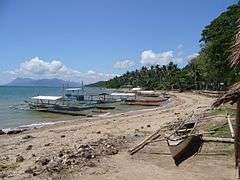
Gallery
|
References
- ↑ "Municipality". Quezon City, Philippines: Department of the Interior and Local Government. Retrieved 31 May 2013.
- ↑ "Province: Leyte". PSGC Interactive. Quezon City, Philippines: Philippine Statistics Authority. Retrieved 12 November 2016.
- 1 2 3 4 Census of Population (2015). "Region VIII (Eastern Visayas)". Total Population by Province, City, Municipality and Barangay. PSA. Retrieved 20 June 2016.
- ↑ Census of Population and Housing (2010). "Region VIII (Eastern Visayas)". Total Population by Province, City, Municipality and Barangay. NSO. Retrieved 29 June 2016.
- ↑ Censuses of Population (1903–2007). "Region VIII (Eastern Visayas)". Table 1. Population Enumerated in Various Censuses by Province/Highly Urbanized City: 1903 to 2007. NSO.
- ↑ "Province of Leyte". Municipality Population Data. Local Water Utilities Administration Research Division. Retrieved 17 December 2016.
External links
- Philippine Standard Geographic Code
- Official website of the Municipality of Calubian
- Local Governance Performance Management System
Places adjacent to Calubian, Leyte | ||||||||||
|---|---|---|---|---|---|---|---|---|---|---|
| ||||||||||
Tacloban (capital) | |
| Municipalities |
|
| Component city | |
| Independent component city |
|
| Highly urbanized city |
|
This article is issued from
Wikipedia.
The text is licensed under Creative Commons - Attribution - Sharealike.
Additional terms may apply for the media files.