Serra Malagueta (village)
| Serra Malagueta | |
|---|---|
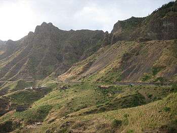 Landscape around the village which is Serra da Malagueta | |
 | |
| Coordinates: 15°11′03″N 23°41′24″W / 15.1842°N 23.6899°WCoordinates: 15°11′03″N 23°41′24″W / 15.1842°N 23.6899°W | |
| Country | Cape Verde |
| Island | Santiago |
| Municipality | Santa Catarina |
| Civil parish | Santa Catarina |
| Population (2010)[1] | |
| • Total | 572 |
Serra Malagueta is a settlement in the northwestcentral part of the island of Santiago, Cape Verde. It is part of the municipality of Santa Catarina. It is situated on the main road between Assomada and Tarrafal (EN1-ST01), 1 km south of Curral Velho (municipality of Tarrafal), 3 km (1.9 mi) north of Fundura and 11 km (6.8 mi) north of Assomada. In 2010 its population was 572. The main village, Locotano, sits at about 800 m elevation, northwest of the summit of Serra Malagueta, and lies partly in the Serra Malagueta Natural Park.[2]
References
- ↑ "2010 Census results". Instituto Nacional de Estatística Cabo Verde (in Portuguese). 24 November 2016.
- ↑ Parques Naturais, Áreas protegidas Cabo Verde
This article is issued from
Wikipedia.
The text is licensed under Creative Commons - Attribution - Sharealike.
Additional terms may apply for the media files.