San Bartolomé de Tirajana
| San Bartolomé de Tirajana | ||
|---|---|---|
| Municipality | ||
 San Bartolomé de Tirajana | ||
| ||
 Municipal location in Gran Canaria | ||
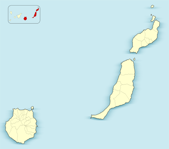 San Bartolomé de Tirajana Location in the province of Las Palmas  San Bartolomé de Tirajana San Bartolomé de Tirajana (Canary Islands)  San Bartolomé de Tirajana San Bartolomé de Tirajana (Spain, Canary Islands) | ||
| Coordinates: 27°55′32″N 15°34′21″W / 27.92556°N 15.57250°WCoordinates: 27°55′32″N 15°34′21″W / 27.92556°N 15.57250°W | ||
| Country |
| |
| Autonomous Community |
| |
| Province | Las Palmas | |
| Island | Gran Canaria | |
| Government | ||
| • Mayor | Marco Aurelio Pérez (PP) | |
| Area[1] | ||
| • Total | 333.13 km2 (128.62 sq mi) | |
| Population (2013)[2] | ||
| • Total | 56,698 | |
| • Density | 170/km2 (440/sq mi) | |
| Time zone | UTC+0 (CET) | |
| • Summer (DST) | UTC+1 (CEST (GMT +1)) | |
| Postal code | 35290 | |
| Area code(s) | 928 & 828 | |
| Website | www.maspalomas.com | |

San Bartolomé de Tirajana is a village and a Spanish municipality in the south-eastern part of the island of Gran Canaria in the Las Palmas province in the Canary Islands. With an area of 333.13 km2 (128.62 sq mi),[1] San Bartolomé de Tirajana is the largest municipality in area on the island as well as the Canary Islands. The population is 56,698 (2013).[2]
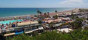
The municipality contains the large beach resorts of Maspalomas, including Playa del Inglés and San Agustín, and the Pilancones natural park. The municipal capital, the village of San Bartolomé de Tirajana is situated in the mountains, 17 km (11 mi) from the coast and 27 km (17 mi) south-west of Las Palmas, at about 900 m (2,953 ft) elevation. Most of the population lives along the Atlantic coastline. The GC-1 motorway passes through the southern part of the municipality, and connects it with Las Palmas de Gran Canaria and the Gran Canaria Airport.
Historical population
| Historical population | ||||||||||||||||||||||||||||
|---|---|---|---|---|---|---|---|---|---|---|---|---|---|---|---|---|---|---|---|---|---|---|---|---|---|---|---|---|
|
| |||||||||||||||||||||||||||
Settlements

A
- Agualatente
- Aldea Blanca
- Arteara
- Ayacata
- Ayagaures
B
- Bahia Feliz
- Berriel
C
- Calderin
- Campo Internacional
- El Canalizo
- Casas Blancas
- Los Caserones de Fataga
- Castillo del Romeral
- Los Cercados
- Cercados de Araña
- Cercados de Espino
- Chira
- Ciudad de Lima
- La Culata
F
- Fataga
- Las Filipinas
- La Florida
H
- Hoya Gercia
- Hoya Grande
- Hoya de Tunte
- Los Hortigones
- Huesa Bermeja
- La Humbria
J
- Juan Grande
L
- Lomito de Taidía
- Lomo de la Palma
M
- Maspalomas
- El Matorral
- Media Fanega
- Los Meloneras
- La Mimbre
- La Montaña
- Montaña La Data
- Montaña de Rosiana
- Monteleon
- El Moral
P
- El Pajar
- Los Palmitos
- Pasito Blanco
- Pedrazo
- Perera
- La Plata
- Playa del Aguila
- Playa del Inglés
R
- Risco Blanco
- Risco la Candelilla
- Los Rodeos
S
- El Salobre
- San Agustín
- San Fernando
- Santa Águeda
- El Sequero
- Los Sitios
- Sonnenland
T
- El Tablero
- Taidía
- Tarajalillo
- Las Tederas
- Trejo
- Tunte (San Bartolomé de Tirajana)

Education
The British School of Gran Canaria maintains its South Campus in this municipality.[3]
Climate
It is located on the leeward portion of the island. Humid winds cover the northeast in the summer months. Precipitation is lower than the northern part of the island and temperatures are slightly higher than in the north all year round.
See also
References
- 1 2 Instituto Canario de Estadística, area
- 1 2 Instituto Canario de Estadística Archived 2014-04-24 at the Wayback Machine., population
- ↑ "Contact." The British School of Gran Canaria. Retrieved on April 8, 2015. "South Campus Address C\ Mar de Azor, 3 El Hornillo 35100 San Bartolomé de Tirajana Las Palmas"
External links
![]()
Places adjacent to San Bartolomé de Tirajana | ||||||||||
|---|---|---|---|---|---|---|---|---|---|---|
| ||||||||||