Arrecife
| Arrecife | |||
|---|---|---|---|
| City | |||
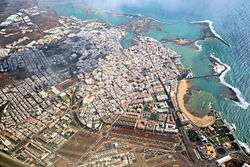 Aerial view of Arrecife | |||
| |||
| Etymology: Spanish for Reef | |||
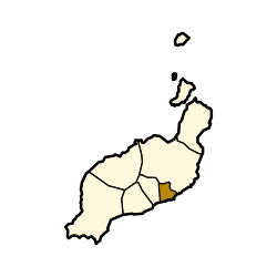 Municipal location in Lanzarote | |||
_-_OSM_Mapnik.svg.png) Arrecife Location in Lanzarote 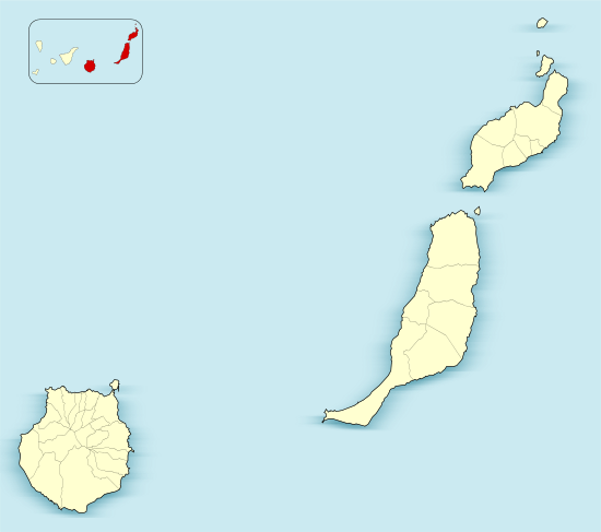 Arrecife Arrecife (Province of Las Palmas)  Arrecife Arrecife (Canary Islands)  Arrecife Arrecife (Spain, Canary Islands) | |||
| Coordinates: 28°57′45″N 13°33′2″W / 28.96250°N 13.55056°WCoordinates: 28°57′45″N 13°33′2″W / 28.96250°N 13.55056°W | |||
| Country |
| ||
| Autonomous Community |
| ||
| Province | Las Palmas | ||
| Island | Lanzarote | ||
| Government | |||
| • Mayor | Manuel Fajardo Feo (CC) | ||
| Area[1] | |||
| • Total | 22.72 km2 (8.77 sq mi) | ||
| Elevation(AMSL) | 20 m (70 ft) | ||
| Population (2013)[2] | |||
| • Total | 55,673 | ||
| • Density | 2,500/km2 (6,300/sq mi) | ||
| Time zone | UTC+0 (CET) | ||
| • Summer (DST) | UTC+1 (CEST (GMT +1)) | ||
| Postal code | 35500 | ||
| Area code(s) | +34 (Spain) + 928 (Las Palmas) | ||
| Website | www.arrecife.es | ||

Arrecife (/ˌærəˈsiːfeɪ/; Spanish pronunciation: [areˈsife]) is a city and municipality in the Canary Islands (Spain) situated in the centre-east of the island of Lanzarote, of which it has been the capital since 1852. The city owes its name to the rock reef ('Arrecife' is Spanish for 'reef') which covers the beach located in the city. The city also gives its name to the nearby Arrecife Airport.
The population of the municipality is 55,673 (2013),[2] its area is 22.72 km².[1] It is south of Haría, east of Tinajo and northeast of Yaiza. Arrecife is a port town on the east coast, served by ferries to the other islands and also Europe and mainland Africa. The LZ1 road connects Arrecife with to the north, the LZ2 road with the southwest, and the LZ3 road serves as the beltway of the city. The tallest building in Lanzarote is the Arrecife Gran Hotel, which is located on the front alongside the harbour.
History
The earliest records of Arrecife date from the fifteenth century when it was a small fishing settlement. The name, given then as Arrecifes, refers to the black volcanic reefs behind which boats could hide, protected from sudden pirate attacks.
Towards the end of the sixteenth century the settlement began to grow in response to a need for accommodation and warehousing to support growing trade between the old and new worlds. The first church was constructed at this time, consecrated to the first bishop of Arrecife, San Ginés. Growing prosperity increased the attractiveness of the town as a pirate target: in 1571 a notorious pirate named Dogan plundered and almost completely destroyed the little port town.
In 1964 Arrecife became the site of Lanzarote's first sea-water desalination plant, which was still operational in 2010.
Climate
Lanzarote has a desert climate according to the Köppen climatic classification.[3] The little precipitation is concentrated in the winter months.
| Climate data for Lanzarote Airport (1981-2010) | |||||||||||||
|---|---|---|---|---|---|---|---|---|---|---|---|---|---|
| Month | Jan | Feb | Mar | Apr | May | Jun | Jul | Aug | Sep | Oct | Nov | Dec | Year |
| Record high °C (°F) | 27.9 (82.2) |
29.0 (84.2) |
32.7 (90.9) |
36.3 (97.3) |
42.6 (108.7) |
40.7 (105.3) |
42.9 (109.2) |
43.6 (110.5) |
40.5 (104.9) |
37.1 (98.8) |
34.2 (93.6) |
27.5 (81.5) |
43.6 (110.5) |
| Average high °C (°F) | 20.7 (69.3) |
21.3 (70.3) |
22.9 (73.2) |
23.5 (74.3) |
24.6 (76.3) |
26.3 (79.3) |
28.2 (82.8) |
29.1 (84.4) |
28.6 (83.5) |
26.7 (80.1) |
24.2 (75.6) |
21.8 (71.2) |
24.8 (76.6) |
| Daily mean °C (°F) | 17.4 (63.3) |
17.9 (64.2) |
19.0 (66.2) |
19.6 (67.3) |
20.8 (69.4) |
22.6 (72.7) |
24.3 (75.7) |
25.2 (77.4) |
24.7 (76.5) |
23.0 (73.4) |
20.7 (69.3) |
18.6 (65.5) |
21.1 (70) |
| Average low °C (°F) | 14.0 (57.2) |
14.3 (57.7) |
15.0 (59) |
15.7 (60.3) |
16.8 (62.2) |
18.8 (65.8) |
20.4 (68.7) |
21.2 (70.2) |
20.8 (69.4) |
19.4 (66.9) |
17.2 (63) |
15.4 (59.7) |
17.4 (63.3) |
| Record low °C (°F) | 8.0 (46.4) |
9.0 (48.2) |
8.3 (46.9) |
9.5 (49.1) |
11.5 (52.7) |
12.4 (54.3) |
15.4 (59.7) |
16.6 (61.9) |
15.5 (59.9) |
12.0 (53.6) |
10.9 (51.6) |
9.0 (48.2) |
8.0 (46.4) |
| Average rainfall mm (inches) | 16.5 (0.65) |
18.2 (0.717) |
12.5 (0.492) |
5.2 (0.205) |
1.5 (0.059) |
0.1 (0.004) |
0.0 (0) |
0.5 (0.02) |
2.2 (0.087) |
9.9 (0.39) |
14.7 (0.579) |
29.3 (1.154) |
110.6 (4.357) |
| Average rainy days (≥ 1.0 mm) | 3 | 3 | 2 | 1 | 0 | 0 | 0 | 0 | 0 | 2 | 3 | 4 | 18 |
| Mean monthly sunshine hours | 203 | 201 | 241 | 255 | 297 | 292 | 308 | 295 | 248 | 235 | 207 | 196 | 2,978 |
| Source: Agencia Estatal de Meteorología[4] | |||||||||||||
Historical population
| Historical population | |||||||||||||||||||
|---|---|---|---|---|---|---|---|---|---|---|---|---|---|---|---|---|---|---|---|
|
| ||||||||||||||||||
Communities
- Urbanización Playa Honda (subdivision), south
Sites of interest
- Playa Reducto, Arrecife's town beach
- Castillo de San José, 18th-century fortress that now houses a collection of modern art
- Puente de Las Bolas, bridge leading to the Castillo de San Gabriel
- Charco de San Ginés, man-made lagoon used by fishermen
Gallery
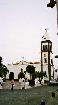 Church
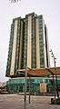 The Gran Hotel Arrecife
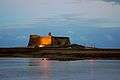 Castle of San Gabriel
See also
References
- 1 2 Instituto Canario de Estadística, area
- 1 2 Instituto Canario de Estadística Archived April 19, 2014, at the Wayback Machine., population
- ↑
- ↑ "Guía resumida del clima en España (1981-2010)".
External links
| Wikimedia Commons has media related to Arrecife. |
| Wikivoyage has a travel guide for Arrecife. |
Places adjacent to Arrecife | ||||||||||
|---|---|---|---|---|---|---|---|---|---|---|
| ||||||||||