Santa Brígida, Las Palmas
| Santa Brígida Sataute | |||
|---|---|---|---|
| Municipality | |||
 Santa Brígida | |||
| |||
| Motto(s): "Por España y por la Fe vencimos al Holandés" | |||
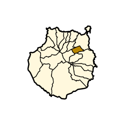 Municipal location in Gran Canaria | |||
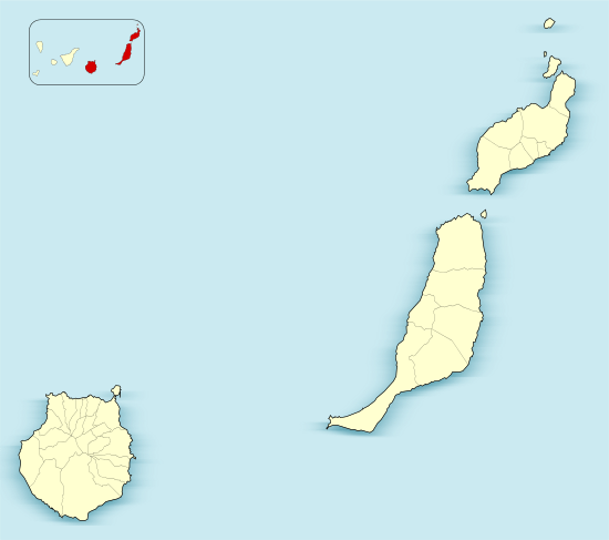 Santa Brígida Location in the province of Las Palmas  Santa Brígida Santa Brígida (Canary Islands)  Santa Brígida Santa Brígida (Spain, Canary Islands) | |||
| Coordinates: 28°2′2″N 15°29′59″W / 28.03389°N 15.49972°WCoordinates: 28°2′2″N 15°29′59″W / 28.03389°N 15.49972°W | |||
| Country |
| ||
| Autonomous Community |
| ||
| Province | Las Palmas | ||
| Island | Gran Canaria | ||
| Government | |||
| • Mayor | José Armando Armengol Martín (Ando Sataute) | ||
| Area[1] | |||
| • Total | 23.81 km2 (9.19 sq mi) | ||
| Elevation(AMSL) | 520 m (1,710 ft) | ||
| Population (2013)[2] | |||
| • Total | 18,971 | ||
| • Density | 800/km2 (2,100/sq mi) | ||
| Demonym(s) | Satauteño/ña | ||
| Time zone | UTC+0 (CET) | ||
| • Summer (DST) | UTC+1 (CEST (GMT +1)) | ||
| Postal code | 35300 | ||
| Area code(s) | +34 (Spain) + 928 (Las Palmas) | ||
| Website | www.santabrigida.es | ||
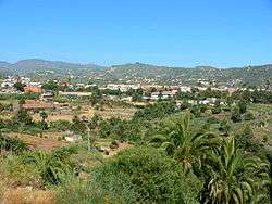
Santa Brígida is a town and a municipality in the northeastern part of the island of Gran Canaria in the Province of Las Palmas of the Canary Islands. Its population is 18,791 (2013),[2] and the area is 23.81 km².[1] It is situated in the mountains, 13 km southwest of Las Palmas.
Historical population
| Historical population | ||||||||||||||||||||||||||||
|---|---|---|---|---|---|---|---|---|---|---|---|---|---|---|---|---|---|---|---|---|---|---|---|---|---|---|---|---|
|
| |||||||||||||||||||||||||||
Sites of interest
- Bandama Caldera (The Caldera de Bandama Natural Monument), part of the Tafira Protected Landscape. This volcanic caldera reaches 569 m (1,867 ft) above sea level at the highest point on its rim, Pico de Bandama, and is about 1,000 m (3,300 ft) wide and 200 m (660 ft) deep. The steep walk to the bottom of the caldera takes about half an hour. Volcanic ash of different hues is in great abundance, and there are some interesting botanic species of Canary Islands origin.
- Archaeological sites in Santa Brígida. In the valley of La Angostura and Las Meleguinas one can find numerous traces of Aboriginal Canarians that have prompted the declaration of the area as a Cultural, as groups of caves carved into rock, silos or sidewalks. In the archaeological site of El Tope, discovered on 16 July 1988, where you can see remnants that suggest the existence of an aboriginal burial mound, as well as ceramics, pottery and curious pintaderas.[3][4] It has been discovered Libyan-Berber inscriptions and some vessels (which are now in the Museo Canario).[3][4] Also in the same area in the wall of the volcano is the Cueva de Los Frailes, a set of 37 caves discovered in 1933.[4]
Panorama
.jpg)
Santa Brígida
.jpg)
Santa Brígida
.jpg)
Santa Brígida
Gallery
.jpg) Santa Brígida
Santa Brígida.jpg) Santa Brígida
Santa Brígida.jpg) Santa Brígida
Santa Brígida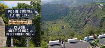
| Wikimedia Commons has media related to Santa Brígida. |
See also
References
- 1 2 Instituto Canario de Estadística, area
- 1 2 Instituto Canario de Estadística Archived 2014-04-22 at Archive.is, population
- 1 2 "Historia de Santa Brígida" Archived 2009-06-25 at the Wayback Machine., Ayuntamiento de Santa Brígida
- 1 2 3 "Lugares de interés histórico cultural de Santa Brígida" , Cabildo de Gran Canaria
Places adjacent to Santa Brígida, Las Palmas | ||||||||||
|---|---|---|---|---|---|---|---|---|---|---|
| ||||||||||
This article is issued from
Wikipedia.
The text is licensed under Creative Commons - Attribution - Sharealike.
Additional terms may apply for the media files.