Saint-Pierre-d'Exideuil
| Saint-Pierre-d'Exideuil | |
|---|---|
| Commune | |
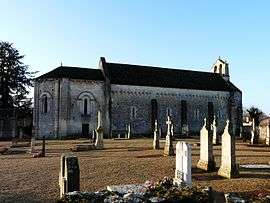 The church of Saint-Pierre and the graveyard | |
 Saint-Pierre-d'Exideuil Location within Nouvelle-Aquitaine region  Saint-Pierre-d'Exideuil | |
| Coordinates: 46°09′06″N 0°16′15″E / 46.1517°N 0.2708°ECoordinates: 46°09′06″N 0°16′15″E / 46.1517°N 0.2708°E | |
| Country | France |
| Region | Nouvelle-Aquitaine |
| Department | Vienne |
| Arrondissement | Montmorillon |
| Canton | Civray |
| Intercommunality | Civraisien |
| Government | |
| • Mayor (2008–2014) | Jean-Marie Peigne |
| Area1 | 19.32 km2 (7.46 sq mi) |
| Population (2006)2 | 828 |
| • Density | 43/km2 (110/sq mi) |
| Time zone | UTC+1 (CET) |
| • Summer (DST) | UTC+2 (CEST) |
| INSEE/Postal code | 86237 /86400 |
| Elevation |
100–147 m (328–482 ft) (avg. 130 m or 430 ft) |
|
1 French Land Register data, which excludes lakes, ponds, glaciers > 1 km2 (0.386 sq mi or 247 acres) and river estuaries. 2 Population without double counting: residents of multiple communes (e.g., students and military personnel) only counted once. | |
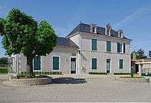
Town hall
Saint-Pierre-d'Exideuil is a commune in the Vienne department in the Nouvelle-Aquitaine region in western France.
See also
References
| Wikimedia Commons has media related to Saint-Pierre-d'Exideuil. |
This article is issued from
Wikipedia.
The text is licensed under Creative Commons - Attribution - Sharealike.
Additional terms may apply for the media files.