Bourg-Archambault
| Bourg-Archambault | |
|---|---|
| Commune | |
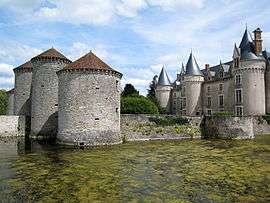 The Chateau of Bourg-Archambault | |
 Bourg-Archambault Location within Nouvelle-Aquitaine region  Bourg-Archambault | |
| Coordinates: 46°23′39″N 1°00′15″E / 46.3942°N 1.0042°ECoordinates: 46°23′39″N 1°00′15″E / 46.3942°N 1.0042°E | |
| Country | France |
| Region | Nouvelle-Aquitaine |
| Department | Vienne |
| Arrondissement | Montmorillon |
| Canton | Montmorillon |
| Intercommunality | Montmorillonnais |
| Government | |
| • Mayor (2008–2014) | Bernard Richefort |
| Area1 | 24.33 km2 (9.39 sq mi) |
| Population (2006)2 | 205 |
| • Density | 8.4/km2 (22/sq mi) |
| Time zone | UTC+1 (CET) |
| • Summer (DST) | UTC+2 (CEST) |
| INSEE/Postal code | 86035 /86390 |
| Elevation |
123–201 m (404–659 ft) (avg. 206 m or 676 ft) |
|
1 French Land Register data, which excludes lakes, ponds, glaciers > 1 km2 (0.386 sq mi or 247 acres) and river estuaries. 2 Population without double counting: residents of multiple communes (e.g., students and military personnel) only counted once. | |
Bourg-Archambault is a commune in the Vienne department in the Nouvelle-Aquitaine region in western France.
Bourg-Archambault has a privately owned chateau of special architectural interest: consisting of a four turreted 'keep' style building which was renovated during 2003: surrounded by a moat and having an entrance bridge and what appears to be a drawbridge tower
Geography
The Salleron forms parts of the commune's western border, then flows northward through its northern part.
See also
References
| Wikimedia Commons has media related to Bourg-Archambault. |
This article is issued from
Wikipedia.
The text is licensed under Creative Commons - Attribution - Sharealike.
Additional terms may apply for the media files.